Maps of Pampas

South America 5.
1 : 2800000 Arrowsmith, Aaron
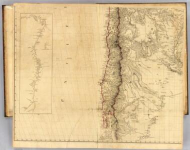
Chili.
1 : 8950000 Lucas, Fielding Jr.
Chili.
1 : 4752000 Lucas, Fielding Jr.
Chili.
1 : 3200000 Pinkerton, John, 1758-1826
Chili. [Karte], in: Novus atlas absolutissimus, Bd. 6, S. 249.
1 Karte aus Atlas Janssonius Offizin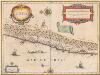
Chili [Karte], in: Novus Atlas, das ist, Weltbeschreibung, Bd. 2, S. 352.
1 Karte aus Atlas Blaeu, Joan Blaeu, Willem Janszoon
Chili [Karte], in: Theatrum orbis terrarum, sive, Atlas novus, Bd. 2, S. 362.
1 Karte aus Atlas Blaeu, Joan Blaeu, Willem Janszoon
Geographisch-statistische und historische Charte von Chile
1 : 3500000 Weimar : Verlag des Geographischen Instituts
CHILI
[Amsterdam : Joan Blaeu]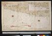
De kusten van Chili
Chile Gerard van Keulen
Chili And Part Of The Viceroyalty Of La Plata.
1 : 5700000 Carey, Mathew
Chili And Part Of The Viceroyalty Of La Plata.
1 : 11100000 Carey, Mathew
Chili.
1 : 8400000 Arrowsmith, Aaron; Lewis, Samuel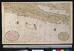
Nieuwe afteekeningh van Chili geeleegen in de Groodt Zuijt Zee
Chile Gerard van Keulen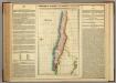
Map Of Chili.
1 : 9757440 Lea, I.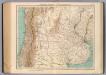
160-61. Argentina e Cile Centrali.
1 : 3000000 Touring club italiano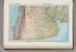
232. Chile, Central; Argentina, Central (Pampa). The World Atlas.
1 : 3750000 USSR (Union of Soviet Socialist Republics).
Coupes du continent Sud Americain.
1 : 2500000 Martin de Moussy, V. (Victor), 1810-1869
Composite: Mapa de la Republica de Chile (1-8)
1 : 11000000 Pissis, Aime, 1812-1889
Carte, Province de Mendoza, l'Araucanie, partie du Chili.
1 : 1870000 Martin de Moussy, V. (Victor), 1810-1869
Carte du Territoire Indien du Sud et de la Région des Pampas
1 : 2000000 Description géographique et statistique de la Confédération Argentine Martin de Moussy, Victor Librairie de Firmin Didot frères, fils et Cie
Carte, Territoire Indien du Sud, Region des Pampas.
1 : 1850000 Martin de Moussy, V. (Victor), 1810-1869
Carte de la Province de Mendoza de L'Araucanie et de la plus grande partie du Chili
1 : 2000000 Description géographique et statistique de la Confédération Argentine Martin de Moussy, Victor Librairie de Firmin Didot frères, fils et Cie
Partie, (Chili, la Plata). Amer. Merid. 36.
1 : 1641836 Vandermaelen, Philippe, 1795-1869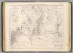
Carte des provinces de Cordova et San Luis.
1 : 1850000 Martin de Moussy, V. (Victor), 1810-1869
Carte des Provinces de Cordova de San Luis et des régions voisines
1 : 2000000 Description géographique et statistique de la Confédération Argentine Martin de Moussy, Victor Librairie de Firmin Didot frères, fils et Cie
Partie, Chili, la Plata. Amer. Merid. 33.
1 : 1641836 Vandermaelen, Philippe, 1795-1869
Rio Negro.
1 : 3170000 Paz Soldan, Mariano Felipe, 1821-1886