Maps of La Pampa

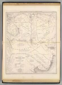
Carte, Territoire Indien du Sud, Region des Pampas.
1 : 1850000 Martin de Moussy, V. (Victor), 1810-1869
Carte du Territoire Indien du Sud et de la Région des Pampas
1 : 2000000 Description géographique et statistique de la Confédération Argentine Martin de Moussy, Victor Librairie de Firmin Didot frères, fils et Cie
Gobernacion de La Pampa.
1 : 2470000 Paz Soldan, Mariano Felipe, 1821-1886
Rio Negro.
1 : 3170000 Paz Soldan, Mariano Felipe, 1821-1886
Provincia de Mendoza.
1 : 1800000 Paz Soldan, Mariano Felipe, 1821-1886
Gobernacion de Neuquen.
1 : 1800000 Paz Soldan, Mariano Felipe, 1821-1886
Provincia de San Luis.
1 : 1800000 Paz Soldan, Mariano Felipe, 1821-1886
Ramon M. Castro
1 : 200000 Argentine. Dirección general de minas y geología [Buenos Aires] : Direccion general de minas, geologia e hidrologia
Cuatreros
1 : 25000 (Argentine) Estado Mayor del Ejercito 3a Division [Buenos Aires] : Estado Mayor del Ejercito 3a Division
Bahia Blanca
1 : 25000 (Argentine) Estado Mayor del Ejercito 3a Division [Buenos Aires] : Estado Mayor del Ejercito 3a Division
Grünbein
1 : 25000 (Argentine) Gran Estado Mayor 3a Division [Buenos Aires] : Gran Estado Mayor 3a Division
Coupes du continent Sud Americain.
1 : 2500000 Martin de Moussy, V. (Victor), 1810-1869
160-61. Argentina e Cile Centrali.
1 : 3000000 Touring club italiano
232. Chile, Central; Argentina, Central (Pampa). The World Atlas.
1 : 3750000 USSR (Union of Soviet Socialist Republics).
Carte, Province de Mendoza, l'Araucanie, partie du Chili.
1 : 1870000 Martin de Moussy, V. (Victor), 1810-1869
Partie, (Chili, la Plata). Amer. Merid. 36.
1 : 1641836 Vandermaelen, Philippe, 1795-1869
Partie, la Plata. Amer. Merid. 37.
1 : 1641836 Vandermaelen, Philippe, 1795-1869
Provincia de Mendoza
1 : 1400000 Seelstrang, Arthur Eduard von 1838-1896 Buenos-Aires : G. Kraft
Carte de la Province de Mendoza de L'Araucanie et de la plus grande partie du Chili
1 : 2000000 Description géographique et statistique de la Confédération Argentine Martin de Moussy, Victor Librairie de Firmin Didot frères, fils et Cie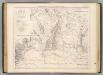
Carte des provinces de Cordova et San Luis.
1 : 1850000 Martin de Moussy, V. (Victor), 1810-1869
Gobernacion del Neuquen
1 : 1400000 Seelstrang, Arthur Eduard von 1838-1896 Buenos-Aires : J. Ruland
Plano del territorio del Neuquen
1 : 570000 Argentina Oficina cartografica Ludwig
Provincia de Buenos-Aires.
1 : 1870000 Paz Soldan, Mariano Felipe, 1821-1886
Partie, Chili, la Plata. Amer. Merid. 33.
1 : 1641836 Vandermaelen, Philippe, 1795-1869
Partie, la Plata. Amer. Merid. 34.
1 : 1641836 Vandermaelen, Philippe, 1795-1869
Provincia de Cordoba.
1 : 1800000 Paz Soldan, Mariano Felipe, 1821-1886
Demarcacion de limites con Chile. Plano general de la sub-comision n°2
1 : 500000 Argentine. Oficina de Límites Internacionales [Buenos Aires ?] :
South America 5.
1 : 2800000 Arrowsmith, Aaron
Chili And Part Of The Viceroyalty Of La Plata.
1 : 5700000 Carey, Mathew