Maps of Mendoza

Carte, Province de Mendoza, l'Araucanie, partie du Chili.
1 : 1870000 Martin de Moussy, V. (Victor), 1810-1869
Carte de la Province de Mendoza de L'Araucanie et de la plus grande partie du Chili
1 : 2000000 Description géographique et statistique de la Confédération Argentine Martin de Moussy, Victor Librairie de Firmin Didot frères, fils et Cie
Provincia de Mendoza
1 : 1400000 Seelstrang, Arthur Eduard von 1838-1896 Buenos-Aires : G. Kraft
Partie, (Chili, la Plata). Amer. Merid. 36.
1 : 1641836 Vandermaelen, Philippe, 1795-1869
Gobernacion de Neuquen.
1 : 1800000 Paz Soldan, Mariano Felipe, 1821-1886
Gobernacion del Neuquen
1 : 1400000 Seelstrang, Arthur Eduard von 1838-1896 Buenos-Aires : J. Ruland
Partie, Chili, la Plata. Amer. Merid. 33.
1 : 1641836 Vandermaelen, Philippe, 1795-1869
Plano del territorio del Neuquen
1 : 570000 Argentina Oficina cartografica Ludwig
Provincia de Mendoza.
1 : 1800000 Paz Soldan, Mariano Felipe, 1821-1886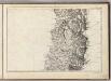
(Mapa de la Republica de Chile 5)
1 : 11000000 Pissis, Aime, 1812-1889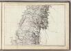
(Mapa de la Republica de Chile 6)
1 : 11000000 Pissis, Aime, 1812-1889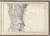
(Mapa de la Republica de Chile 7)
1 : 11000000 Pissis, Aime, 1812-1889
Departamento de tierras y colonizacion
1 : 1000000 (Chili) Servicio de Mensura y Clasificacion de Tierras Santiago du Chili : Taller del Servicio de Mensura y Clasificacion de Tierras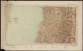
Republica de Chile [33°-35° S]
1 : 500000 (Chili) Oficina de Mensura de Tierras Santiago du Chili : Oficina de Mensura de Tierras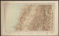
Republica de Chile [35°-37° S]
1 : 500000 (Chili) Oficina de Mensura de Tierras Santiago du Chili : Oficina de Mensura de Tierras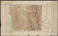
Republica de Chile [37°-39° S]
1 : 500000 (Chili) Oficina de Mensura de Tierras Santiago du Chili : Oficina de Mensura de Tierras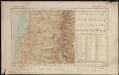
Republica de Chile [39°-41° S]
1 : 500000 (Chili) Oficina de Mensura de Tierras Santiago du Chili : Oficina de Mensura de Tierras
Provincia de San Luis.
1 : 1800000 Paz Soldan, Mariano Felipe, 1821-1886
Gobernacion de La Pampa.
1 : 2470000 Paz Soldan, Mariano Felipe, 1821-1886
Demarcacion de limites con Chile. Plano general de la sub-comision n°2
1 : 500000 Argentine. Oficina de Límites Internacionales [Buenos Aires ?] :
Demarcacion de limites con Chile. Plano general de la sub-comision n°3
1 : 500000 Argentine. Oficina de Límites Internacionales [Buenos Aires ?] :
Demarcacion de limites con Chile. Plano general de la sub-comision n°5
1 : 500000 Argentine. Oficina de Límites Internacionales [Buenos Aires ?] :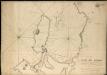
Plano del Puerto de la Concepcion de Chile, citu[a]da la Poblacion de Talcaguano en la latitud S. de 36o,42',28" y en longitud al O' de cadiz de 67o,2',53"
1 : 48000
Demarcacion de limites con Chile. Plano general de la sub-comision n°4
1 : 500000 Argentine. Oficina de Límites Internacionales [Buenos Aires ?] :
Ramon M. Castro
1 : 200000 Argentine. Dirección general de minas y geología [Buenos Aires] : Direccion general de minas, geologia e hidrologia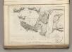
Plan of the Bay of Conception in Chili.
La Perouse, Jean-Francois de Galaup, comte de, 1741-1788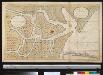
Nieuwe afteekening van de rivier van Baldivia is geleegen in de Zuijt Zee aen de kust van Chili
Chile Gerard van Keulen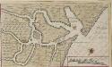
Afteekeningh en de opdoeninge van de rivier van Baldivia
Chile Gerard van Keulen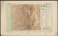
Republica de Chile [31°-33° S]
1 : 500000 (Chili) Oficina de Mensura de Tierras Santiago du Chili : Oficina de Mensura de Tierras


