Maps of Provincia de Valparaíso

Chili.
1 : 8400000 Arrowsmith, Aaron; Lewis, Samuel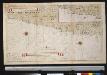
De kusten van Chili
Chile Gerard van Keulen
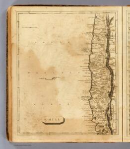
Chili.
1 : 3200000 Pinkerton, John, 1758-1826
Chili.
1 : 4752000 Lucas, Fielding Jr.
Geographisch-statistische und historische Charte von Chile
1 : 3500000 Weimar : Verlag des Geographischen Instituts
Chili.
1 : 8950000 Lucas, Fielding Jr.
Chile
1 : 6630000 Chile im Verlage des Geographischen Instituts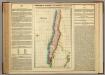
Map Of Chili.
1 : 9757440 Lea, I.
Chili. [Karte], in: Novus atlas absolutissimus, Bd. 6, S. 249.
1 Karte aus Atlas Janssonius Offizin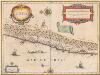
Chili [Karte], in: Novus Atlas, das ist, Weltbeschreibung, Bd. 2, S. 352.
1 Karte aus Atlas Blaeu, Joan Blaeu, Willem Janszoon
Chili [Karte], in: Theatrum orbis terrarum, sive, Atlas novus, Bd. 2, S. 362.
1 Karte aus Atlas Blaeu, Joan Blaeu, Willem Janszoon
South America 5.
1 : 2800000 Arrowsmith, Aaron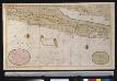
Nieuwe afteekeningh van Chili geeleegen in de Groodt Zuijt Zee
Chile Gerard van Keulen
CHILI
[Amsterdam : Joan Blaeu]
Chili, cote.
1 : 2500000 Spain. Marina

Composite: Mapa de la Republica de Chile (1-8)
1 : 11000000 Pissis, Aime, 1812-1889
Carte de la Province de Mendoza de L'Araucanie et de la plus grande partie du Chili
1 : 2000000 Description géographique et statistique de la Confédération Argentine Martin de Moussy, Victor Librairie de Firmin Didot frères, fils et Cie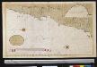
Een gedeelte van de kust van Chili in de Zuijd Zee van P. El Guasco tot R. IJtata
Chile Gerard van Keulen
Carte, Province de Mendoza, l'Araucanie, partie du Chili.
1 : 1870000 Martin de Moussy, V. (Victor), 1810-1869
Partie, (Chili, la Plata). Amer. Merid. 36.
1 : 1641836 Vandermaelen, Philippe, 1795-1869
Partie du Chili. Amer. Merid. 29.
1 : 1641836 Vandermaelen, Philippe, 1795-1869
Provincia de Mendoza
1 : 1400000 Seelstrang, Arthur Eduard von 1838-1896 Buenos-Aires : G. Kraft
Partie, Chili, la Plata. Amer. Merid. 33.
1 : 1641836 Vandermaelen, Philippe, 1795-1869
Gobernacion del Neuquen
1 : 1400000 Seelstrang, Arthur Eduard von 1838-1896 Buenos-Aires : J. Ruland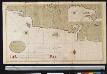
Een gedeelte van de kust van Chili in de Zuijd Zee van Po. IJtata tot El Laguia of van 36 tot 41 graden Breete
Chile Gerard van Keulen
Carte des Provinces de la Rioja de San Juan et des régions voisines
1 : 2000000 Description géographique et statistique de la Confédération Argentine Martin de Moussy, Victor Librairie de Firmin Didot frères, fils et Cie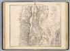
Carte, provinces de La Rioja et San Juan.
1 : 1850000 Martin de Moussy, V. (Victor), 1810-1869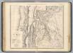
Catamarca et Tucuman.
1 : 1850000 Martin de Moussy, V. (Victor), 1810-1869