Maps of Argentina
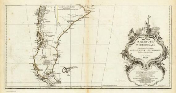
Amerique Meridionale. (Southern section)
1 : 6300000 Anville, Jean Baptiste Bourguignon d, 1697-1782
Karte von Süd-America
Jižní Amerika Anville, Jean-Baptiste Bourguinon d' Alberti, Ignaz F.A. Schraembl
Patagonia. South Orkney or Powell's Group. Falkland Islands. South Georgia Island.
Colton, G.W.
A new map of the southern parts of America taken from manuscript maps made in the country and a survey of the eastern coast maode by the order of the King of Spain
1 : 3168000
Paskaarte van't zuÿdelÿckste deel van America
1 Karte : Kupferdruck ; 43 x 53 cm Doncker bÿ Hendrick Doncker boeckverkoper en graad-boog-maker inde Nieuwe-brug-steeg
[147][150] Tractus Australior Americae Meridionalis ..., uit: Atlas sive Descriptio terrarum orbis
Annotatie: Gedigitaliseerde versie. Amsterdam. Heiloo : Picturae (vervaardiger), 2015. tiff-bestand. Gedigitaliseerd: 07-01-2015; Origineel: Universiteitsbibliotheek Vrije Universiteit (XL.05127.-) ; Netherlands; Titelpagina ontbreekt Wit, Frederik de Amsterdam : Frederick de Wit
Tractus australior Americæ meridionalis a Rio de la Plata per fretum Magellanicum ad Toraltum
1 Karte : Kupferdruck ; 48 x 54 cm Renard Louis Renard
Le Chili, avec les contrées voisines et le pays des Patagons
1 : 10700000 Chile Bonne, Rigobert André
Amerique Merid., cotes.
1 : 5500000 Spain. Marina
Patagonia. South Orkney or Powell's Group. Falkland Islands. South Georgia Island.
1 : 7750000 Colton, G.W.
Patagonie, Terre de Feu, Malouines.
1 : 3750000 Martin de Moussy, V. (Victor), 1810-1869
Südlichster Theil von America enthaltend Patagonia, Feuerland & Falklands Gruppe
Grosser Hand-Atlas über alle Theile der Erde in 170 Karten Meyer, J. Verlag des Bibliographischen Instituts
Carte de la Patagonie et des Archipels de la Terre de Feu des Malounies et des Còtes Occidentales
1 : 2000000 Description géographique et statistique de la Confédération Argentine Martin de Moussy, Victor Librairie de Firmin Didot frères, fils et Cie
Esquisse de la Patagonie (République Argentine)
1 : 6000000 Paris : Erhard et fils
Patagonia, S. Shetlands, S. Orkneys.
1 : 6700000 Society for the Diffusion of Useful Knowledge (Great Britain)
Patagonia. South Orkney or Powell's Group. Falkland Islands. South Georgia Island.
1 : 7600000 Colton, G.W.
South America 6.
1 : 6969600 Letts, Son & Co.
Patagonia, Feuerland, Falklands, Antarctische Continent.
1 : 7700000 Radefeld, Carl Christian Franz, 1788-1874
Patagonia ... South Orkney ... Falkland Islands ... South Georgia Island.
1 : 8236800 Colton, G.W.
Composite: (Mapa de la Republica de Chile 9-15)
1 : 11000000 Pissis, Aime, 1812-1889
S. extremity of America.
1 : 4500000 Cook, James, 1728-1779
Coupes du continent Sud Americain.
1 : 2500000 Martin de Moussy, V. (Victor), 1810-1869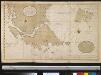
Verbeeterde caert van de uijthoek van Zuijd America waer in vervat sijn de onlangs ondekte eijlanden, door de scheepen van St. Malo, zedert den jaaren 1700, welker west sijde nog onbekent is, de doortogt, die hier met de naam van St. Barbara genaemt word is, onlangs den 25 Maij 1713 ontdeckt door een schip t welk dien naam hadt
Chile Gerard van Keulen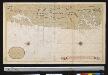
Afteekening van een gedeelte van de kust van Chili in de Zuijd Zee van El Laguia tot C. de la Victoria
Chile Gerard van Keulen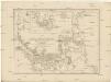
Karte der Magellanischen Strasse
Falklandy De la Cruz Cano y Olmedilla, Juan Bougainville, Jean-Pierre de F.A. Schraembl
Iles Malouines ou Falkland. Amer. Merid. 41.
1 : 1641836 Vandermaelen, Philippe, 1795-1869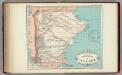
Gobernacion de Santa Cruz.
1 : 2160000 Paz Soldan, Mariano Felipe, 1821-1886
Exquisita & magno aliquot mensium periculo lustrata et iam retecta Freti Magellanici Facies. [...] [Karte], in: Gerardi Mercatoris Atlas, sive, Cosmographicae meditationes de fabrica mundi et fabricati figura, S. 562.
1 Karte aus Atlas Mercator, Gerhard Montanus, Petrus
Partie, (Chili, la Plata). Amer. Merid. 36.
1 : 1641836 Vandermaelen, Philippe, 1795-1869