Maps of Argentina

Tractus australior Americæ meridionalis a Rio de la Plata per fretum Magellanicum ad Toraltum
1 Karte : Kupferdruck ; 48 x 54 cm Renard Louis Renard
Mapa de la Republica Argentina
1 : 8500000 Oficina meteorologica nacional. Buenos Aires [Buenos Aires] : Tall. de la Officina Meteorologica
Missioni Salesiane della Patagonia settentrionale
1 : 2000000 Falklandy Salesianische Buchdruckerei
Paskaarte van't zuÿdelÿckste deel van America
1 Karte : Kupferdruck ; 43 x 53 cm Doncker bÿ Hendrick Doncker boeckverkoper en graad-boog-maker inde Nieuwe-brug-steeg
[147][150] Tractus Australior Americae Meridionalis ..., uit: Atlas sive Descriptio terrarum orbis
Annotatie: Gedigitaliseerde versie. Amsterdam. Heiloo : Picturae (vervaardiger), 2015. tiff-bestand. Gedigitaliseerd: 07-01-2015; Origineel: Universiteitsbibliotheek Vrije Universiteit (XL.05127.-) ; Netherlands; Titelpagina ontbreekt Wit, Frederik de Amsterdam : Frederick de Wit
159. Argentina e Cile.
1 : 10000000 Touring club italiano
Republica Argentina - Superficie, poblacion, ferrocarriles, cultivos y ganados
1 : 7400000 Argentine. Ministerio de agricultura [Buenos Aires] : Direccion de economia rural y estadistica
Mapa orohidrografico de la Republica Argentina.
1 : 8500000 Paz Soldan, Mariano Felipe, 1821-1886
Mapa general de la Republica Argentina.
1 : 8500000 Paz Soldan, Mariano Felipe, 1821-1886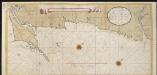
Het Zuijdelijkste gedeelte van Brazieliea van Rio de La Plata tot de Straat van Magalani of C. de Hoorn
Argentina Gerard van Keulen
A new map of the southern parts of America taken from manuscript maps made in the country and a survey of the eastern coast maode by the order of the King of Spain
1 : 3168000
Chili, Plata, et Patagonie.
1 : 15000000 Malte-Brun, Conrad, 1775-1826
Nuevo mapa de la Republica Argentina, Chile, Uruguay y Paraguay.
1 : 4000000 Ludwig, Pablo
Chili, La Plata, Uruguay.
1 : 7500000 Meyer, Joseph, 1796-1856
Patagonia. South Orkney or Powell's Group. Falkland Islands. South Georgia Island.
Colton, G.W.
Le Chili, avec les contrées voisines et le pays des Patagons
1 : 10700000 Chile Bonne, Rigobert André
Patagonie, Detroit de Magellan, Terres Australes.
1 : 6000000 Garnier, F. A., 1803-1863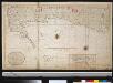
Het zuijdelijkste gedeelte van Brazilia van Rio de La Plata tot Caap de Hoorn of door de Straat van Magalanüs
Argentina Gerard van Keulen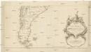
Karte von Süd-America
Jižní Amerika Anville, Jean-Baptiste Bourguinon d' Alberti, Ignaz F.A. Schraembl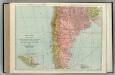
Chile, Bolivia, Peru, Ecuador, Uruguay, Paraguay, Argentine Republic. (southern half).
1 : 5020000 Rand McNally and Company
Provinces of La Plata, The Banda Oriental del Uruguay and Chile.
1 : 4435200 Parish, Woodbine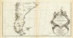
Amerique Meridionale. (Southern section)
1 : 6300000 Anville, Jean Baptiste Bourguignon d, 1697-1782
Dietrich Reimers Handkarte von Argentinien, Paraguay und Uruguay, sowie Teilen von Chile und Brasilien
1 : 5000000 Argentina Dietrich Reimer
Südlichster Theil von America enthaltend Patagonia, Feuerland & Falklands Gruppe
Grosser Hand-Atlas über alle Theile der Erde in 170 Karten Meyer, J. Verlag des Bibliographischen Instituts
Ferro-carriles, correos y telegrafos, Republica Argentina.
1 : 6000000 Paz Soldan, Mariano Felipe, 1821-1886
Chili et Argentine, Flle. Nord.
1 : 6000000 Vivien St Martin, L.
Patagonia, S. Shetlands, S. Orkneys.
1 : 6700000 Society for the Diffusion of Useful Knowledge (Great Britain)
[Süd-Amerika in 6 Blättern, Blatt 5]
Adolf Stieler's Handatlas über alle Theile der Erde und über das Weltgebäude Stieler, Adolf Justus Perthes
Karte der zwischen Argentinien und Chile streitigen Grenzgebiete
1 : 4000000 Alemann, T. Litog. Rüegg & Mülli


