Maps of Greater Antilles
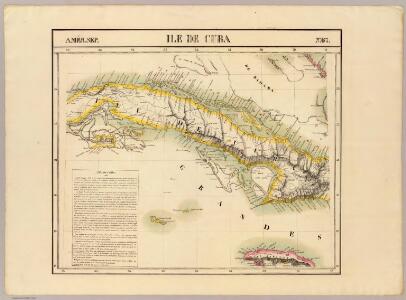
Cuba. Amer. Sep. 67.
1 : 1641836 Vandermaelen, Philippe, 1795-1869
Island of Haiti. Lesser Antilles. Puerto Rico. Cuba.
1 : 3095000 Hammond, C.S.
Cuba mit den benachbarten Inseln und Gebieten
1 : 6000000 Atlantský oceán Carl Flemming
Cuba Insula ; Hispaniola Insula
1 : 1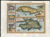
Zeilan Insula
1 : 1
Cuba, Jamaica and Puerto Rico.
1 : 2950000 Colton, G.W.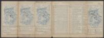
Cuba Insula [Karte], in: Gerardi Mercatoris Atlas, sive, Cosmographicae meditationes de fabrica mundi et fabricati figura, S. 556.
1 Karte aus Atlas Mercator, Gerhard Montanus, Petrus
Cuba, Jamaica and Puerto Rico.
1 : 3000000 Colton, G.W.
Cuba en Iamaica : soo als die door Kolumbus ontdekt, en by de Kastilianen bevolkt sijn = les de Cuba et de la Jamaique : ainsi qu'elles ont été prémierement découvertes par Christ. Colombe, ensuite peuplées par les Castillans ...
1 : 6500000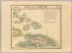
Haiti ou St. Domingue. Amer. Sep. 68.
1 : 1641836 Vandermaelen, Philippe, 1795-1869
Partie du Sahara. Afrique 12.
1 : 1641836 Vandermaelen, Philippe, 1795-1869
Partie, Desert de Sahara. Afrique 13.
1 : 1641836 Vandermaelen, Philippe, 1795-1869
Partie, Desert de Sahara. Afrique 14.
1 : 1641836 Vandermaelen, Philippe, 1795-1869
Touariks. Afrique 15.
1 : 1641836 Vandermaelen, Philippe, 1795-1869
Partie du Sahara. Afrique 16.
1 : 1641836 Vandermaelen, Philippe, 1795-1869
Desert de Lybie. Afrique 17.
1 : 1641836 Vandermaelen, Philippe, 1795-1869
Nubie. Afrique 18.
1 : 1641836 Vandermaelen, Philippe, 1795-1869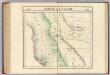
Partie, l'Arabie. Asie 90.
1 : 1641836 Vandermaelen, Philippe, 1795-1869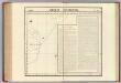
Arabie Heureuse. Asie 91.
1 : 1641836 Vandermaelen, Philippe, 1795-1869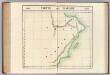
Partie, l'Arabie. Asie 92.
1 : 1641836 Vandermaelen, Philippe, 1795-1869
Porto Rico. Amer. Sep. 69.
1 : 1641836 Vandermaelen, Philippe, 1795-1869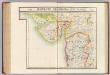
Guzerate, Chandeish et Aurungabad. Asie 93.
1 : 1641836 Vandermaelen, Philippe, 1795-1869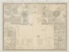
[Posesiones de America, Isla de Cuba]
1 : 1000000 Coello, Francisco [Verlag nicht ermittelbar]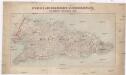
Spanisch-Amerikanischer Kriegsschauplatz
1 : 600000 Kuba Dietrich Reimer
Carte des isles situées au nord de St. Domingue
1 : 1
Carta geogro topográfica de la isla de Cuba /dedicanla a... Isabel II el teniente general conde de Cuba y la comision de gefes y oficiales militares y agrimensores públicos que la levantó y formó... de 1824 á 1831; Do Estruch lo grabó en Barcelona 1835...
1 : 320000 1 mapa en 6 fulls. Dirección y realización: J.G.J. Valcourt. - Finestres: ciiudad y puerto de la Habana; Santiago de Cuba; Bahia de Cuba; ciudad y bahia de Sn. Carlos de Matanzas; ciudad de Trinidad; Puerto de Casilda; Sta. Maria de Puerto Principe Estruch, Domingo; Roca, Carlos (dibujó); [Valcourt Iznardi, José Gaspar Jasme] Do Estruch y Jordán
De Noordkust van Espaniola van Cabo Francesos tot I. Tortuga vertonende de Machenille int groodt alles geleght na de nieuste afteekeninge
Haiti Gerard van Keulen
Carta geogro topográfica de la isla de Cuba /dedicanla a... Isabel II el teniente general conde de Cuba y la comision de gefes y oficiales militares y agrimensores públicos que la levantó y formó... de 1824 á 1831; Do Estruch lo grabó en Barcelona 1835...
1 : 320000 1 mapa en 6 fulls. Dirección y realización: J.G.J. Valcourt. - Finestres: ciiudad y puerto de la Habana; Santiago de Cuba; Bahia de Cuba; ciudad y bahia de Sn. Carlos de Matanzas; ciudad de Trinidad; Puerto de Casilda; Sta. Maria de Puerto Principe Estruch, Domingo; Roca, Carlos (dibujó); [Valcourt Iznardi, José Gaspar Jasme] Do Estruch y Jordán