Maps of Oued el Dahab

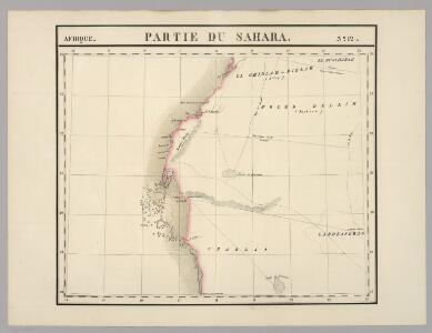
Partie du Sahara. Afrique 12.
1 : 1641836 Vandermaelen, Philippe, 1795-1869
Mission A. Gruvel en Mauritanie
1 : 2000000 Hansen, Jules-André-Arthur 1849-1931 [Paris] : Société de Géographie de Paris
Genehoa, Jaloffi, et Sierraliones Regna. [Karte], in: Novus atlas absolutissimus, Bd. 6, S. 174.
1 Karte aus Atlas Janssonius Offizin
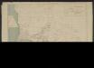
Le Sahara Occidental d'après trois pèlerins de l'Adrar
1 : 1754385 Masqueray, Émile 1843-1894 Alger : imp. A. Jourdan
Carte de la Mauritanie
1 : 1000000 Merlaud-Ponty, Gérard M. Service géographique des colonies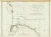
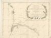
Carte particuliere de la Cote occidentale de l'Afrique, depuis le Cap Blanc jusqu'au Cap de Verga. (Northern section)
1 : 1320000 Anville, Jean Baptiste Bourguignon d, 1697-1782
Saint-Louis. Edition provisoire (Afrique)
1 : 1000000 Afrique occidentale française. Service géographique Paris : Service géographique de l'Afrique Occidentale Française
Specialkarte der West-Kϋste von Africa von Cabo Blanco bis Cabo Verga

Islands In The Atlantic.
1 : 285120 Tallis, J. & F.
Karte von der westlichen kuste von Africa : von der strasse bey Gibraltar bis zu dem XI grade norderbreite ...wahrnehmungen entworfen
1 : 1
A chart of the western coast of Africa, from the Straits of Gibraltar to eleven degrees of north latitude, including the Canary & Cape Verd Islands
1 : 13000000
Partie occidentale de l'Afrique
1 : 9600000 Afrika západní Bonne, Rigobert André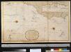
Generaale kaart van de kust van Barbarija van Portugaal tot Cabo Verde als ook de Carnarisse, Vlaamse en Zoute Eijl.
Atlantic Ocean Gerard van Keulen
Spezial-Karte von Afrika
1 : 4000000 Blatt 1 Habenicht, Hermann Perthes
Barbariae et Guineae maritimi à freto Gibraltar ad fluvium Gambiae cum Insulis Salfis Flandrisis et Canaricis
1 : 55000000
De cust van Barbaria, Gualata, Arguyn en Geneheo van Capo S Vincente tot Capo Verde
1 : 6000000
Barbariæ et Guineæ maritimi à freto Gibraltar ad fluvium Gambiæ
1 Karte : Kupferdruck ; 47 x 56 cm Renard apud L. Renard
Paskaart van de cust van Portugal, Barbaria en Genehoa, beginnende van d'Barlenges tot aan C. Verde met al zyn Diepte en Drooghte dus ver Naaukeurig opgesocht door Ervaren Stuurlieden
1 : 5200000
[135][138] Barbariae et Guineae Maritimi ..., uit: Atlas sive Descriptio terrarum orbis
Annotatie: Gedigitaliseerde versie. Amsterdam. Heiloo : Picturae (vervaardiger), 2015. tiff-bestand. Gedigitaliseerd: 07-01-2015; Origineel: Universiteitsbibliotheek Vrije Universiteit (XL.05127.-) ; Netherlands; Titelpagina ontbreekt Wit, Frederik de Amsterdam : Frederick de Wit
Spezial - karte von AfricaSektion West-Sahara (1)
1 : 4000000 1 full d'1 mapa en 10 fulls i estoig Hermann Habenicht; Justus Perthes
Partie occidentale de l'ancien continent depuis Lisbonne jusquà la Riviere de Sierra Leona, avec l'Isle Madere, les Isles Canaires, et celles du C. Verd
1 : 11500000
de Vlaamsche en Canarische Eylanden [Karte], in: De Nieuwe Groote Vermeerderde Zee-Atlas ofte Water-Werelt, S. 55.
1 Karte aus Atlas Doncker, Hendrick
Carte reduite des costes occidentales d'Afrique
1 : 2700000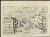
Insulae Capitis Viridis
1 : 1
Specialkarte der West-Küste von Africa von Cabo Blanco bis Cabo Verga nebst dem Lauf der Flüsse Senegal und Gambia
1 : 1320000 Afrika západní Anville, Jean-Baptiste Bourguinon d' Schraembl, Franz Anton im I.G. Trasslerischen Verlag
Specialkarte der West-Küste von Africa von Cabo Blanco bis Cabo Verga nebst dem Lauf der Flüsse Senegal und Gambia
1 : 1320000 Afrika západní Anville, Jean-Baptiste Bourguinon d' Schraembl, Franz Anton im I.G. Trasslerischen Verlag
[Specialkarte der West-Küste von Africa von Cabo Blanco bis Cabo Verga nebst dem Lauf der Flüsse Senegal und Gambia]
Afrika západní Anville, Jean-Baptiste Bourguinon d' Schraembl, Franz Anton im I.G. Trasslerischen Verlag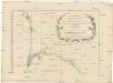
Specialkarte der West-Küste von Africa von Cabo Blanco bis Cabo Verga nebst dem Lauf der Flüsse Senegal und Gambia
1 : 1320000 Afrika západní Anville, Jean-Baptiste Bourguinon d' Schraembl, Franz Anton im I.G. Trasslerischen Verlag