Maps of Morocco

Partie occidentale de l'ancien continent depuis Lisbonne jusquà la Riviere de Sierra Leona, avec l'Isle Madere, les Isles Canaires, et celles du C. Verd
1 : 11500000
Carte d'une parte de l'Afrique
1 : 5860000 Afrika severozápadní Lapie, Pierre
Partie occidentale de l'Afrique
1 : 9600000 Afrika západní Bonne, Rigobert André
Barbariae et Guineae maritimi à freto Gibraltar ad fluvium Gambiae cum Insulis Salfis Flandrisis et Canaricis
1 : 55000000
Karte von der westlichen kuste von Africa : von der strasse bey Gibraltar bis zu dem XI grade norderbreite ...wahrnehmungen entworfen
1 : 1
A chart of the western coast of Africa, from the Straits of Gibraltar to eleven degrees of north latitude, including the Canary & Cape Verd Islands
1 : 13000000
Pascaart, Waer in men claarlyck zien can, alle havens rivieren droogten, gelegen tußchen C.S. Vincent en C. Verde [...] [Karte], in: Het vijfde Deel Des Grooten Atlas : Vervatende De Water-Weereld, S. 182.
1 Karte aus Atlas Jansson, Jan Jansson, Jan
De cust van Barbaria, Gualata, Arguyn, en Geneheo, van Capo S. Vincente tot Capo Verde
1 : 6000000 Annotatie: Uit: De lichtende columne, ofte zeespiegel ... - Amsterdam : Anthony Jacobsz., 1644 [Amsterdam : Anthony Jabobsz.]
Pascaart, Waer in men claarlyck zien can, alle havens rivieren droogten, gelegen tußchen C.S. Vincent en C. Verde [...] [Karte], in: Novus atlas absolutissimus, Bd. 9, S. 239.
1 Karte aus Atlas Janssonius Offizin
A chart of the coast of Barbaria with the western, Canaria, & Cape de Verd, isles
1 : 6000000
[135][138] Barbariae et Guineae Maritimi ..., uit: Atlas sive Descriptio terrarum orbis
Annotatie: Gedigitaliseerde versie. Amsterdam. Heiloo : Picturae (vervaardiger), 2015. tiff-bestand. Gedigitaliseerd: 07-01-2015; Origineel: Universiteitsbibliotheek Vrije Universiteit (XL.05127.-) ; Netherlands; Titelpagina ontbreekt Wit, Frederik de Amsterdam : Frederick de Wit
de Vlaamsche en Canarische Eylanden [Karte], in: De Nieuwe Groote Vermeerderde Zee-Atlas ofte Water-Werelt, S. 55.
1 Karte aus Atlas Doncker, Hendrick
De cust van Barbaria, Gualata, Arguyn en Geneheo van Capo S. Vincent tot Capo Verde
1 Karte : Kupferdruck ; 42 x 53 cm Doncker bÿ Hendrick Doncker boecverkoper en graadboog-maker inde Nieuwe-brug-steech
Barbariæ et Guineæ maritimi à freto Gibraltar ad fluvium Gambiæ
1 Karte : Kupferdruck ; 47 x 56 cm Renard apud L. Renard
Paskaart van de cust van Portugal, Barbaria en Genehoa, beginnende van d'Barlenges tot aan C. Verde met al zyn Diepte en Drooghte dus ver Naaukeurig opgesocht door Ervaren Stuurlieden
1 : 5200000
De cust van Barbaria, Gualata, Arguyn en Geneheo van Capo S Vincente tot Capo Verde
1 : 6000000
Generaale kaart van de kust van Barbarija van Portugaal tot Cabo Verde als ook de Carnarisse, Vlaamse en Zoute Eijl.
Atlantic Ocean Gerard van Keulen
Spezial - karte von AfricaSektion West-Sahara (1)
1 : 4000000 1 full d'1 mapa en 10 fulls i estoig Hermann Habenicht; Justus Perthes
Islands In The Atlantic.
1 : 285120 Tallis, J. & F.
Spezial-Karte von Afrika
1 : 4000000 Blatt 1 Habenicht, Hermann Perthes
Specialkarte der West-Küste von Africa von Cabo Blanco bis Cabo Verga nebst dem Lauf der Flüsse Senegal und Gambia
1 : 1320000 Afrika západní Anville, Jean-Baptiste Bourguinon d' Schraembl, Franz Anton im I.G. Trasslerischen Verlag
Specialkarte der West-Küste von Africa von Cabo Blanco bis Cabo Verga nebst dem Lauf der Flüsse Senegal und Gambia
1 : 1320000 Afrika západní Anville, Jean-Baptiste Bourguinon d' Schraembl, Franz Anton im I.G. Trasslerischen Verlag
[Specialkarte der West-Küste von Africa von Cabo Blanco bis Cabo Verga nebst dem Lauf der Flüsse Senegal und Gambia]
Afrika západní Anville, Jean-Baptiste Bourguinon d' Schraembl, Franz Anton im I.G. Trasslerischen Verlag
Specialkarte der West-Küste von Africa von Cabo Blanco bis Cabo Verga nebst dem Lauf der Flüsse Senegal und Gambia
1 : 1320000 Afrika západní Anville, Jean-Baptiste Bourguinon d' Schraembl, Franz Anton im I.G. Trasslerischen Verlag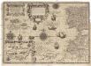
Cassiterides insulae vulgo Asores, & naucleris belgicis insulae Flandricae dictae, quod Brugenses Flandri, ipsas primi detexerint & habitaverint, cum antea incultissimae essent
1 : 548000 Azory Doetechum, Johannes Baptista van
Karte von Fes und Marócos
Fez (Maroko) Canzler, Friedrich Gottlieb Haest in der Weigel- und Schneiderschen Handlung
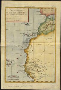
Carte reduite des costes occidentales d'Afrique
1 : 2700000
Fessae, Et Marocchi Regna Africae Celeberr. [Karte] Congi Regni Christiani, In Africa, Nova Descriptio. [Nebenkarte], in: Theatrum orbis terrarum, S. 421.
1 Karte aus Atlas Ortelius, Abraham Vrients, Jan Baptista