Maps of Morocco
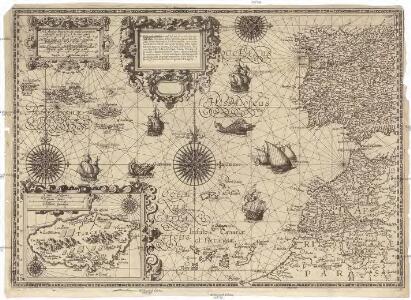
Cassiterides insulae vulgo Asores, & naucleris belgicis insulae Flandricae dictae, quod Brugenses Flandri, ipsas primi detexerint & habitaverint, cum antea incultissimae essent
1 : 548000 Azory Doetechum, Johannes Baptista van
A New Chart of the Madeira and Canary Islands
1 : 1200000 Heather, W. (William) Heather, W. (William)
Antilia, 1463.
Benincasa, Andrea
Fessae, Et Marocchi Regna Africae Celeberr. [Karte] Congi Regni Christiani, In Africa, Nova Descriptio. [Nebenkarte], in: Theatrum orbis terrarum, S. 421.
1 Karte aus Atlas Ortelius, Abraham Vrients, Jan Baptista
A chart of the Canary islands, including Madeira
Kanárské ostrovy Borda, Jean-Charles de Norie & Co.

Fessae et Marocchi Regna. [Karte], in: Gerardi Mercatoris Atlas, sive, Cosmographicae meditationes de fabrica mundi et fabricati figura, S. 502.
1 Karte aus Atlas Mercator, Gerhard Montanus, Petrus
Fessae, Et Marocchi Regna Africae Celeberr. [Karte] Congi Regni Christiani, In Africa, Nova Descriptio. [Nebenkarte], in: Theatrum orbis terrarum, S. 320.
1 Karte aus Atlas Ortelius, Abraham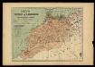
Mapa del imperio de Marruecos ó Moghreb-El-Aksá / trazado con los datos mas recientes por Benito Chias y Carbó, ingeniero militar; J. Soler g[rabó]
1 : 3000000 1 Mapa, col. Datació aproximada. Chias Carbó, Benet [Alberto Martin editor?]
Carte de l'empire de Maroc
1 : 2000000 Gibraltarský průliv Renou, E. Delsol, Th. Langlois et Leclercq
[XVI], uit: Geognostische Karte des Oesterreichischen Kaiserstaates mit einem grossen Theile Deutschland's u. Italien / hauptsachlich nach ... Haidinger's geognostischer Karte dieses Staates bearb. von Josef Scheda
1 : 3000000 titelvariant: General-Karte von Europa in 25 Blättern; Annotatie: Bijlage bij: General-Karte von Europa in 25 Blättern. - 1:2.592.000. - 1845-1847 Scheda, Joseph Wien : K.K. Militär. Geografisch. Institut
A chart of the Maderas and Canary Islands.
1 : 1770000 Jefferys, Thomas
INSULÆ | CANARIÆ, | Alias | FORTUNATÆ | dictæ.
[Amsterdam : Joan Blaeu]
Insulae Canariae, olim Fortunatae Dictae. [Karte], in: Novus atlas absolutissimus, Bd. 9, S. 247.
1 Karte aus Atlas Janssonius Offizin

Insula Canaria olim Fortunatae ... / Joannies Essensis
1 : 1000000 Annotatie: Met opgeplakte windroos en titelcartouche; Annotatie geografische gegevens: Oost boven Essen, Joan van [Antwerpen : J. van Essen]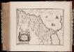
Fezzae et Marocchi regna Africae celeberrima, / describebat Abrah. Ortelius
1 : 3000000 Annotatie: Middenonder: Melvia Rio, middenboven: Atlanticvs, (met komma); Origineel is Blad 206 in atlas factice; Annotatie geografische gegevens: Met schaalstok; West boven Abraham Ortelius 1527-1598 [Amsterdami : apud Guiljelmum et Iohannem Blaeu]
Feuille 36 (A VI), uit: Carte géologique internationale de l'Europe : la carte, votée au congrès géologique international de Bologne en 1881, est exécutée conformément aux décisions d'une commission internationale, avec le concours des gouvernements, sous le dir. de M.M. Beyrich et Hauchecorne
Annotatie: Blad 48 gamme des couleurs; blad 49: bladwijzer en titelblad Heinrich Ernst Beyrich 1815-1896; Wi. Hauchecorne Berlin : Reimer / (Berlin: Institut lithographique)
Iles Canaries et Madere. Afrique 5.
1 : 1641836 Vandermaelen, Philippe, 1795-1869
FEZZÆ | ET | MAROCCHI | REGNA AFRICÆ | CELEBERRIMA
describente | Abrah: Ortelius. [Amsterdam : Joan Blaeu]
Fezzae Et Marocchi Regna Africae Celeberrima [Karte], in: Le théâtre du monde, ou, Nouvel atlas contenant les chartes et descriptions de tous les païs de la terre, Bd. 2, S. 284.
1 Karte aus Atlas Blaeu, Willem Janszoon und Blaeu, Joan Blaeu, Willem Janszoon
Nord-Atlantischer Ozean
1 : 750000 Afrika Reichs-Marine-Amt
Fezzae Et Marocchi Regna Africae Celeberrima [Karte], in: Novus Atlas, das ist, Weltbeschreibung, Bd. 2, S. 246.
1 Karte aus Atlas Blaeu, Joan Blaeu, Willem Janszoon
Fezzae Et Marocchi Regna Africae Celeberrima [Karte], in: Theatrum orbis terrarum, sive, Atlas novus, Bd. 2, S. 293.
1 Karte aus Atlas Blaeu, Joan Blaeu, Willem Janszoon
Neueste Generalkarte von Portugal und Spanien, 4
1 Blatt : 69 x 50 cm Schrämbl
Fezzae Et Marocchi Regna Africae Celeberrima [Karte], in: Gerardi Mercatoris et I. Hondii Newer Atlas, oder, Grosses Weltbuch, Bd. 2, S. 365.
1 Karte aus Atlas Mercator, Gerhard und Hondius, Jodocus Jansson, Jan
Insulae Flandricae, olim Asores Dictae. [Karte], in: Novus atlas absolutissimus, Bd. 9, S. 244.
1 Karte aus Atlas Janssonius Offizin
Maroc.
1 : 2500000 Vivien St Martin, L.
Chart of the Acores (Hawks) Islands.
1 : 1550000 Jefferys, Thomas