Maps of Algeria

Spezial - karte von AfricaSektion West-Sahara (1)
1 : 4000000 1 full d'1 mapa en 10 fulls i estoig Hermann Habenicht; Justus Perthes
Spezial-Karte von Afrika
1 : 4000000 Blatt 1 Habenicht, Hermann Perthes
Carte d'une parte de l'Afrique
1 : 5860000 Afrika severozápadní Lapie, Pierre
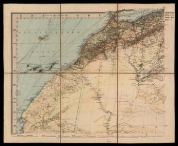
Sahara occidental et central
1 : 4000000 Afrika severozápadní Meunier, Alexandre imp. photo-métallo Millet
Afrika
1 : 7500000 Afrika severozápadní Domann, Bruno Justus Perthes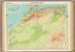
North-west Africa.
1 : 5000000 John Bartholomew and Son
Routes de caravanes du Sahara Occidental
1 : 8000000 Soller, Charles; Société de géographie commerciale de Paris Paris : Société de Géographie Commerciale de Paris
Partie occidentale de l'ancien continent depuis Lisbonne jusquà la Riviere de Sierra Leona, avec l'Isle Madere, les Isles Canaires, et celles du C. Verd
1 : 11500000
de Vlaamsche en Canarische Eylanden [Karte], in: De Nieuwe Groote Vermeerderde Zee-Atlas ofte Water-Werelt, S. 55.
1 Karte aus Atlas Doncker, Hendrick
Pascaart, Waer in men claarlyck zien can, alle havens rivieren droogten, gelegen tußchen C.S. Vincent en C. Verde [...] [Karte], in: Novus atlas absolutissimus, Bd. 9, S. 239.
1 Karte aus Atlas Janssonius Offizin
Paskaart van de cust van Portugal, Barbaria en Genehoa, beginnende van d'Barlenges tot aan C. Verde met al zyn Diepte en Drooghte dus ver Naaukeurig opgesocht door Ervaren Stuurlieden
1 : 5200000
Barbariae et Guineae maritimi à freto Gibraltar ad fluvium Gambiae cum Insulis Salfis Flandrisis et Canaricis
1 : 55000000
Barbariæ et Guineæ maritimi à freto Gibraltar ad fluvium Gambiæ
1 Karte : Kupferdruck ; 47 x 56 cm Renard apud L. Renard
[135][138] Barbariae et Guineae Maritimi ..., uit: Atlas sive Descriptio terrarum orbis
Annotatie: Gedigitaliseerde versie. Amsterdam. Heiloo : Picturae (vervaardiger), 2015. tiff-bestand. Gedigitaliseerd: 07-01-2015; Origineel: Universiteitsbibliotheek Vrije Universiteit (XL.05127.-) ; Netherlands; Titelpagina ontbreekt Wit, Frederik de Amsterdam : Frederick de Wit
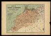
Algérie
1 : 3500000 Alžírsko Gouvernement général de l'Algérie, Service cartographique
Algérie
1 : 3500000 Alžírsko Gouvernement général de l'Algérie, Service cartographique
Karte von der westlichen kuste von Africa : von der strasse bey Gibraltar bis zu dem XI grade norderbreite ...wahrnehmungen entworfen
1 : 1
A chart of the western coast of Africa, from the Straits of Gibraltar to eleven degrees of north latitude, including the Canary & Cape Verd Islands
1 : 13000000
Partie occidentale de l'Afrique
1 : 9600000 Afrika západní Bonne, Rigobert André
Algérie
1 : 7000000 Alžírsko SCGGA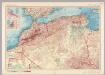
Morocco, Algeria, Tunisia. Pergamon World Atlas.
1 : 5000000 Polish Army Topography Service
De cust van Barbaria, Gualata, Arguyn en Geneheo van Capo S Vincente tot Capo Verde
1 : 6000000
Karte von Fes und Marócos
Fez (Maroko) Canzler, Friedrich Gottlieb Haest in der Weigel- und Schneiderschen Handlung
Algeria, Tunis, Morocco.
1 : 6950000 Rand McNally and Company
Africa Northern.
1 : 6400000 Hall, S. (Sidney)
164-165. Africa, North-west. The World Atlas.
1 : 3750000 USSR (Union of Soviet Socialist Republics).
Carte de l'empire de Maroc
1 : 2000000 Gibraltarský průliv Renou, E. Delsol, Th. Langlois et Leclercq
Fessae et Marocchi Regna. [Karte], in: Gerardi Mercatoris Atlas, sive, Cosmographicae meditationes de fabrica mundi et fabricati figura, S. 502.
1 Karte aus Atlas Mercator, Gerhard Montanus, Petrus
Etats du roi de Maroc, les royaumes d'Alger, de Tunis et de Tripoli, avec les pays circonvoisins
1 : 9600000 Alžírsko Bonne, Rigobert André