Maps of Oman
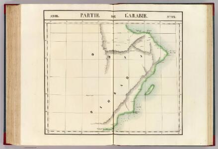
Partie, l'Arabie. Asie 92.
1 : 1641836 Vandermaelen, Philippe, 1795-1869
Oman, Maps MOD MDR Misc 12418
Maskat and Matrah, MDR Misc 12418. From a series of Oman, Maps MOD MDR Misc 12418. Originally published in 1906 under the direction of the Surveyor General of India using 1904-5 data. Reprinted in 1959 and overprinted in 1960. Great Britain. Army. Royal Engineers. Survey Engineers Regiment, 42nd. [Nicosia] : [Survey Directorate, Middle East]
Arabia. N.E. Coast. Gulf of ’Omman. Maskat & Matreh (1911)
[Arabia. N.E. Coast. Gulf of 'Omman. Maskat & Matreh. Surveyed ... 1860. Natural scale 1 : 8,750]
Arabia. N.E. Coast. Gulf of ’Omman. Maskat & Matreh. (1862)
Arabia. N.E. Coast. Gulf of 'Omman. Maskat & Matreh. Surveyed ... 1860. Natural scale 1 : 8,750. London : Admiralty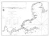
Plan of Muscat Cove and Mutrah Harbour, surveyed in 1785
Plan of Muscat Cove and Mutrah Harbour, surveyed in 1785. By J. McCluer. [London] : A. Dalrymple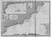
Arabian Sea
Indischer Ozean. Arabisches Meer. Ras Fartak bis Masirah. Maszstab, 1: 1,000,000. (Bender Risut, Churja Murja Bucht, Madraka-Ankerplatz, Merbat Bucht). Berlin : Reichs-Marine-Amt
Perse
Nouvel atlas physique politique et historique de l'Empire ottoman et des états limitrophes en Europe, en Asie et en Afrique, en quarante feuilles Hellert, J.J. Bellizard, Dufour et Cie
152-153. Arabian Peninsula. Bahrein (Bahrain) Islands. The World Atlas.
1 : 5000000 USSR (Union of Soviet Socialist Republics).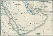
Osmanische Vasallenstaaten in Arabien
1 : 27000000 Osmanisches Reich, Arabien, Protektorat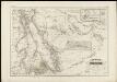
Arabia und das Nil-land
1 : 400000 den Manen Karsten Niebuhr's und den hochverdienten Forschern L.G. Ehrenberg u. E. Rüppell zugeeignet vom Verfasser [Heinrich Karl Wilhelm Berghaus] gestochen von Adolph Maedel in Weimar Gotha : bei Justus Perthes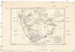
Arabie, mer Rouge, et Golfe Persique
1 : 11350000 Arabský poloostrov Bonne, Rigobert André
Arabia.
1 : 11200000 Tallis, J. & F.
Arabien
1 : 5700000 entworfen und gezeichnet von C.F. Weiland Weimar : Verlag des Geograph. Instituts
Arabien
1 : 6000000 Omán Kiepert, Heinrich Nöedeke, Th. D. Reimer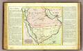
L'Arabie.
1 : 7000000 Clouet, J. B. L. (Jean-Baptiste Louis), b. 1730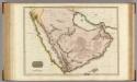
Arabia.
1 : 4500000 Pinkerton, John, 1758-1826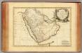
Arabie.
1 : 9300000 Bonne, Rigobert, 1727-1794
91. Arabia.
1 : 10000000 Touring club italiano
ARABIA.
[Amsterdam : Joan Blaeu]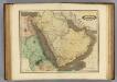
Arabia, Egypt, Nubia.
1 : 6500000 Lizars, Daniel
Nona Asiae Tabula [Karte], in: Claudii Ptolemei viri Alexandrini mathematice discipline philosophi doctissimi geographie opus [...], S. 217.
1 Karte aus Atlas Waldseemüller, Martin [und Ptolemaeus, Claudius] Übelin, Georg
Tabula Asiae IX. [Karte], in: Geographia universalis vetus et nova complectens Claudii Ptolemaei Alexandrini enarrationis libros VIII, S. 290.
1 Karte aus Atlas Münster, Sebastian [und Ptolemaeus, Claudius]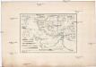
Reduzirte-Karte vom PERSISCHEN GOLF
1 : 2100000 Perský záliv Berghaus, Heinrich Karl Wilhelm Herterich, C. H. Justus Perthes
Persian Gulf (Western Sheet)
Asia. Persian Gulf. Compiled by Commr. C.G. Constable and Lieut. A.W. Stiffe, 1860. Sheikh Sháyb Anchorage. By Commr. C.G. Constable. [Admiralty Chart]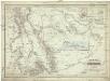
Arabia und das Nil-Land
1 : 4000000 Arabský poloostrov Berghaus, Heinrich Karl Wilhelm Ehrenberg, L. G. Justus Perthes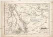
Arabia und das Nil-Land
1 : 4000000 Arabský poloostrov Berghaus, Heinrich Karl Wilhelm Ehrenberg, L. G. Justus Perthes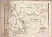
Arabia und das Nil-Land
1 : 4000000 Arabský poloostrov Berghaus, Heinrich Karl Wilhelm Ehrenberg, L. G. Justus Perthes
Arabiae Felicis, Petraeae et Desertae nova et accurata delineatio. [Karte], in: Novus atlas absolutissimus, Bd. 6, S. 102.
1 Karte aus Atlas Janssonius Offizin
Neueste Karte von Arabien
Grosser Hand-Atlas über alle Theile der Erde in 170 Karten Meyer, J. Verlag des Bibliographischen Instituts