Maps of Ivory Coast

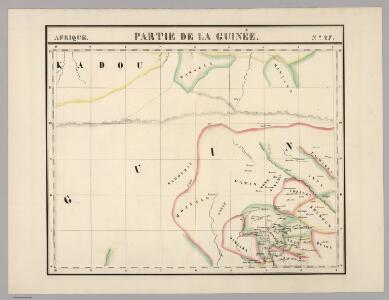
Partie, la Guinee. Afrique 27.
1 : 1641836 Vandermaelen, Philippe, 1795-1869
Carte administrative de la Côte d'Ivoire. Répartition des cercles au 1er janvier 1909
1 : 2000000 Afrique occidentale française. Service géographique
The Gold Coast with Togoland under British Mandate
Huppenbauer
Carta corográfica del Estado de Panamá
1 : 810000 Colombia. Comisión Corográfica Comisión Corográfica
Carte de la Côte d'Ivoire dressée par A. Meunier. Kouadiokofi
1 : 500000 A. Meunier Paris : Service Géographique des Colonies
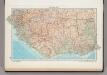
Ghana Road Map (North) 1957
Road map of Ghana, GSGS 4903. Later redesignated as Series G451. Great Britain. War Office. [London] : D. Survey, War Office & Air Ministry.
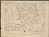
Carte des colonies de l'A.O.F. Dabakala
1 : 500000 Afrique occidentale française. Service géographique Paris : Henry Barrère
Carte des colonies de l'A.O.F. Bobo-Dioulasso
1 : 500000 Afrique occidentale française. Service géographique Paris : Henry Barrère
Carte des colonies de l'A.O.F. Tenkodogo
1 : 500000 Afrique occidentale française. Service géographique Paris : Blondel la Rougery
Koumina
1 : 500000 Galliéni, Joseph-Simon 1849-1916 Paris : Erhard Fres
Carte des colonies de l'A.O.F. Bondoukou
1 : 500000 Afrique occidentale française. Service géographique Paris : Henry Barrère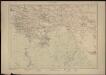
Carte de la Côte d'Ivoire dressée par A. Meunier. Séguéla
1 : 500000 A. Meunier Paris : Service Géographique des Colonies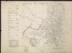
Coomassie (Kumase) Gold Coast

Colonie de la Côte d'Ivoire. Toumodi. Régions centrales du Baoulé
1 : 150000 Pobéguin, Henri 1856-1951 [Paris] :
Key Plan - Kumasi Town Layout

Colonie de la Côte d'Ivoire. Ouosso. Région sud du Baoulé
1 : 150000 Pobéguin, Henri 1856-1951 [Paris] :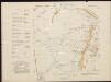
Kibbi (Kyebi) Gold Coast

Anum Stationsgebiet gez. Von R. Bürki Missionar

Map of Togo. A1. Sansane-Mangu
166. West Africa, South. The World Atlas.
1 : 3750000 USSR (Union of Soviet Socialist Republics).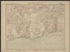
Carte de l'Afrique occidentale française. Bingerville, Porto-Novo
1 : 2000000 France. Service géographique des colonies [Paris] : Service géographique des colonies
Die Goldküste und Togo.

Die Goldküste und Togo. Uebersichtskarte mit den Missionsstationen der Basler- und der Norddeutschen Missionsgesellschaft

Togo

Carte géologique de l'Afrique occidentale française au 1 000 000e
1 : 1000000 Francouzská západní Afrika Hubert, Henry Émile Larose
Ghana Road Map (South) 1957
Road map of Ghana, GSGS 4903. Later redesignated as Series G451. Great Britain. War Office. [London] : D. Survey, War Office & Air Ministry.
Mohamm. Händler auf der Goldküste

östlicher Teil der Gold-KüsteBasler Missions-Gebiet
Carte des colonies de l'A.O.F. Odienné
1 : 500000 Afrique occidentale française. Service géographique Paris : Henry Barrère