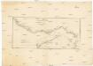
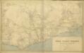
Maps of Kumasi

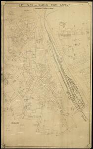
Key Plan - Kumasi Town Layout

Coomassie (Kumase) Gold Coast

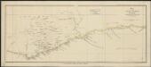
The Gold Coast of Africa.
Dorsch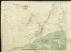
A Map of the Gold Coast and Inland Countries between and beyond the Pra and Volta by the Basel Missionaries on the Gold Coast

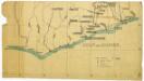
Eastern-District of the Gold Coast

Die Goldküste und westliche Sklavenküste sowie das südliche Asante Reich in Westafrika
Atlas der evangelischen Missions-Gesellschaft zu Basel Locher; Gross, Rudolf Im Verlag des Comptoires der evangelischen Missions-Gesellschaft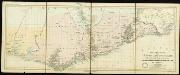
Special map of the inland countries on the Gold Coast up to Kumasi, an Anglo-African theater of war in 1874. By A. Petermann

östlicher Teil der Gold-KüsteBasler Missions-Gebiet
Map of the Gold Coast Colony and neighbouring territories
Map of the Gold Coast Colony and neighbouring territories, IDWO 1097. Great Britain. War Office. Intelligence Division. [London] : [War Office, Intelligence Division].
Ghana Road Map (South) 1957
Road map of Ghana, GSGS 4903. Later redesignated as Series G451. Great Britain. War Office. [London] : D. Survey, War Office & Air Ministry.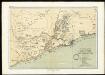
The mission fields on the Gold Coast and the western parts of the Slave Coast
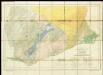
Geological Map of the Gold Coast. Southern Sheet. Showing Positions of Gold Mines and Prospects
Untitled

Mohamm. Händler auf der Goldküste
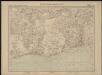
Map of the Gold Coast : to accompany Dr. Madden's report
1 : 1250000 John Arrowsmith, lith. [London] : James & Luke J. Hansard, printers
Kaart van de Goud-Kust of Kust van Guinea / door Js. van den Bosch ; gegraveerd door C. van Baarsel en Zoon
C. van Baarsel en Zoon s-Gravenhage ; Amsterdam : Gebroeders van Cleef
Die Missionen auf der Gold-Küste und Sklaven-Küste

Eastern District of the Gold Coast. The Head-Stations and the Out-Stations of the Basel Mission are underlined

The Gold Coast with Togoland under British Mandate
Huppenbauer
Partie, la Guinee. Afrique 27.
1 : 1641836 Vandermaelen, Philippe, 1795-1869
Togo

Die Goldküste und Togo. Uebersichtskarte mit den Missionsstationen der Basler- und der Norddeutschen Missionsgesellschaft

Die Goldküste und Togo.

Odumase und Aussenstationen
Carte de l'Afrique occidentale française. Bingerville, Porto-Novo
1 : 2000000 France. Service géographique des colonies [Paris] : Service géographique des colonies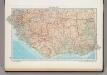
166. West Africa, South. The World Atlas.
1 : 3750000 USSR (Union of Soviet Socialist Republics).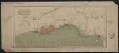
Carte des possessions anglaises et françaises sur le Golfe de Guinée
1 : 4600000 Paris : impr. de F. Menetrier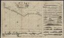
Pas caarte vande Gryen-Cust en Adaows Qua Quaas tuhessen de Serraliones en C. de Tres Puntas
1 : 2500000 t'Amsterdam : bij Joannes van Keulen Boeck-ver cooper en graad boog maecker by de Nieuwe-brug inde gekroonde Lootsman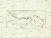
Guinea zwischen Sierra-Leone und dem Aequator
1 : 4120000 Guinea Anville, Jean-Baptiste Bourguinon d' Schraembl, Franz Anton F.A. Schraembl