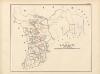
Maps of West Bengal

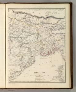
Bengal Etc.
1 : 3380000 Sharpe, J.
Composite: Bengal, Bahar &c.
1 : 750000 Robert Laurie & James Whittle
Carte du Bengale et de ses dépendances
1 Karte : Kupferdruck ; 37 x 53 cm Bolts s.n.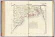
Bengale. Asie 95.
1 : 1641836 Vandermaelen, Philippe, 1795-1869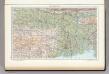
142. Lower Ganga (Ganges) Valley. The World Atlas.
1 : 2500000 USSR (Union of Soviet Socialist Republics).
India 8.
1 : 2217600 Letts, Son & Co.
India VIII. Bengal Presidency.
1 : 2200000 Society for the Diffusion of Useful Knowledge (Great Britain)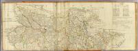
(Bengal, Bahar &c north)
1 : 750000 Robert Laurie & James Whittle
The Province of Bengal
India Office reference collection of maps Survey of India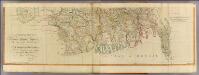
Bengal, Bahar &c. (south)
1 : 750000 Robert Laurie & James Whittle
India and adjacent countries
1 : 1000000 Bangladéš Survey of India offices
Map of the Orissa coast showing the Jagannath and Konarak temples
Watercolour map of the Orissa coast showing the Jagannatha and Konarak temples, by an anonymous artist working in the British school, part of the MacKenzie Collection, dated 1820. Orissa is situated on the eastern seaboard of India, south of Bengal. It is protected by the thickly forested mountains of the Eastern Ghats to the west and is open to the Bay of Bengal to the east. The coastal plains have the highest concentration of historical monuments while along the interior there is a tract of nearly-impenetrable hill country. The map shows two of the most famous temple sites, Puri and Konarak. Puri is one of the cardinal centres of pilgrimage for Hinduism and is the principal centre of the cult of Krishna in his form of Jagannatha, the Lord of the Universe. The Jagannatha temple was founded in the 12th Century by Anantavarman Chodaganga (r.1077-1147), ruler of the Eastern Ganga dynasty. The Rath Yatra (car festival) is the largest annual festival in Puri when the images of Jagannatha, his brother Balabhadra and sister Subhadra are placed in large chariots (raths) and are paraded about the town to symbolise the journey of Krishna from Gokul to Mathura. The great Sun Temple of Konarak stands on the Bay of Bengal, where thousands of pilgrims still come to bathe in the water during the spring festival to celebrate the birth of the Vedic sun god, Surya. The temple was constructed by Narashimhadev, king of the Eastern Ganga dynasty in the 13th century. Conceived as a gigantic chariot with twelve pairs of carved wheels, this temple is an architectural feat for the Orissan style.
A geological, botanical, ethnological, statistical or physical section of the districts of Beerbhoom and Moorshedabad in Bengal 1853
Bengálsko Sherwill, Walter Stanhope Surv. gen. office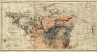
Gold, copper and lead in Chota Nagpore
This is the map contained within the 176-page volume Gold, copper and lead in Chota Nagpore and the adjacent country, compiled by W. King and T.A. Pope and published in Calcutta. King, W., F.G.S. (William) Calcutta : Thacker, Spink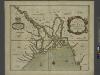
A mapp of the greate river GANGES as ir emptieth it selfe into the bay of BENGALA
from The sea-atlas : containing an hydrographical description of most of the sea-coasts of the known parts of the world.
The Ganges from teh Calligongato its confluence with the Megna or Burrampooter: and the Megna from thence to the head of the Luckla River.
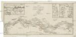
Charte vom Laufe des Ganges von Colgong bis Hurrisonker
1 : 400000 Ganga (Indie a Bangladéš : řeka) Colebrooke, R. H. im Verlage des Geograph. Instituts
District Moorshedabad
India Office reference collection of maps Survey of India
District Maldah
Maps described in the 1878 published catalogue Survey of India
Bhutan, No 78 I, Tongsa
India And Adjacent Countries 1:253,440 or 1" = 4 miles maps Survey of India London : War Office
Bengal, No 79 F
Survey of India
Bengal, Bhutan, Nepal, Sikkim & Tibet, No 78 J, Darjeeling
India And Adjacent Countries 1:253,440 or 1" = 4 miles maps Survey of India
Bengal, No 78 D, Murshidabad
This range contains maps acquired by, or transferred to, the India Office Library and Records in the FCO between 15 August 1947 and 31 December 1973. Items acquired by gift or purchase, in common with all such acquisitions of books and private paper Survey of India
Bengal & Chandernagore, No 79 B, Calcutta
India And Adjacent Countries 1:253,440 or 1" = 4 miles maps Survey of India
Bhutan & Tibet, No 78 E, Punakha
India And Adjacent Countries 1:253,440 or 1" = 4 miles maps Survey of India
Survey of that part of the boundary between the British and Jamoo Territories from the Ravi to the Jhilam
Sheet within the quarter-inch (1:253,440) series of India and Adjacent Countries. This sheet was held by the India Office Records and is currently held in that archive in the British Library. Survey of India
Bengal, No 79 F, Khulna
Survey of India
Bengal, No 79 F, Khulna
This range contains maps acquired by, or transferred to, the India Office Library and Records in the FCO between 15 August 1947 and 31 December 1973. Items acquired by gift or purchase, in common with all such acquisitions of books and private paper Survey of India
Bengal, Bhutan, Nepal, Sikkim & Tibet
1 : 253440 Bengálsko Survey of India offices