Maps of Paul
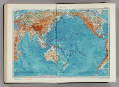
242-243. Pacific and Indian Oceans. The World Atlas.
1 : 40000000 USSR (Union of Soviet Socialist Republics).
Arquipélago de Cabo Verde Ilha de Sto. Antão Porto Novo
1 : 5000 Hydrographic Map Instituto Hidrográfico Portugal Instituto Hidrográfico Portugal
Cabo Verde Carta de S. Vicente
1 : 25000 Topographic Map Serviço Cartográfico do Exército Serviço Cartográfico do Exército
A new chart of the Cape Verd Islands, from the latest authorities
1 : 950000 Heather, W. (William) Heather, W. (William)
Carte des isles du Cap-Verd
1 : 1
Isles Du Cap-Verd = Die Inseln von Capo Verde
1 : 350000
The Cape Verd Islands, laid down from the remarks and observations of experienced navigators
1 : 1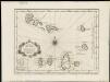
Carte des Isles du Cap Verd = Kaart van de Eilanden van Kabo Verde, geschikt volgens de Daghregisters, en Aanmerkingen, der ervaarendste Zeelieden
1 : 1600000
Insulae Capo Viridis
1 : 1
Isles du Cap Verd
1 : 3800000
Oceano Atlantico norte
1 : 500000 Kapverdy Ministerio das Colonias, Comissao de Cartografia
Les Isles du Cap-Verd
1 : 1950000
INSULÆ | PROMONTORII | VIRIDIS, | Hispanis | ISLAS DE CABO VERDE, | Belgis | DE SOUTE EYLANDEN
[Amsterdam : Joan Blaeu]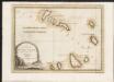
Le Isole di Capo Verde
1 : 900000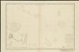
Carte des Isles du Cap Verd, levée en 1819 1820 et 1822
1 : 491000
Karte von den Eylanden des Grünen Vorgebürges, nach den Tagebüchern und Anmerkungen der geschicktesten Seefahrer
1 : 1600000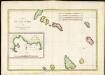
Isles du Cap-Verd
1 : 1200000
Cabo Verde Carta de Sto. Antão
1 : 25000 Topographic Map Serviço Cartográfico do Exército Serviço Cartográfico do Exército
Atlas für Handel und Industrie: Für Kaufleute, Fabrikante u. Gewerbetreibende, Handlungs- u. Gewerbe-Schulen

Pacific Ocean, British Islands.
Goodrich, S.G.
Mapa světa

Der Atlantische Ozean
1 : 40000000 Atlantský oceán (oblast) Groll, Max Institut für Meereskunde der Universität
Pacific Ocean.
1 : 95000000 Huntington, Francis Junius, 1802-1878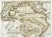
Carte physique de la Grande Mer ci-devant nommée mer du Sud ou Pacifique
1 Karte : Kupferdruck ; 29 x 41 cm, Blattgrösse 47 x 61 cm Buache; Desbruslins Philippe Buache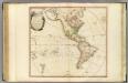
America.
1 : 42000000 Faden, William, 1750?-1836
Carte physique de la mer des Indes
1 Karte : Kupferdruck ; 27 x 34 cm, Blattgrösse 46 x 60 cm Buache; Desbruslins Philippe Buache
E. Hemisphere.
1 : 120000000 Darton, William
America siue India Nova
1 Karte : Kupferdruck ; Durchmesser 34 cm, Bildgrösse 37 x 46 cm Mercator; Mercator; Hondius Henricus Hondius
America siue India Nova
1 Karte : Kupferdruck ; Durchmesser 34 cm, Bildgrösse 37 x 46 cm Mercator; Mercator; Hondius Jodocus Hondius