Maps of Seven Seas (Open Ocean)

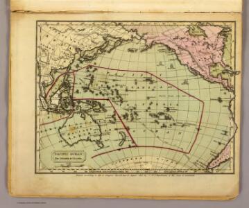
Pacific Ocean.
1 : 95000000 Huntington, Francis Junius, 1802-1878
Pacific Ocean.
1 : 86000000 Smiley, Thomas T.
Afrique spheroidale.
1 : 41000000 Garnier, F. A., 1803-1863
Die sichtbare Seite der Mond-Oberflache bei voller Beleuchtung.
1 : 13000000 Stieler, Adolf
Der Vulkan-Gürtel und die Central-Gruppen des Grossen Oceans
Tichý oceán Buch, Leopold von
Karte von dem Vulkan Gurtel.
1 : 65000000 Berghaus, Heinrich
Picture of the World.
1 : 89000000 Huntington, Hezekiah, 1795-1865
Carte physique de la Grande Mer ci-devant nommée mer du Sud ou Pacifique
1 Karte : Kupferdruck ; 29 x 41 cm, Blattgrösse 47 x 61 cm Buache; Desbruslins Philippe Buache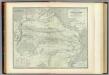
Pacific Ocean.
1 : 45000000 Johnston, Alexander Keith, 1804-1871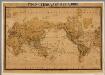
Productenkaart der Aarde / neu bearb. Osw. Meinke
1 : 54600000 Meinke, Osw. Esslingen : Harburger
Oceanica.
1 : 55000000 Gray, Ormando Willis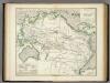
Karte vom Grossen Ocean, (Mare Pacifico).
1 : 90000000 Berghaus, Heinrich
Pacific Ocean.
1 : 80000000 Woodbridge, William C.
Pacific Ocean cables, wireless stations.
1 : 50000000 Philip, George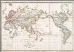
Allgemeine Weltkarte auf welcher alle neue Entdeckungen eines Pérouse, Wilson, Vancouver, Mungo-Park, Brown etc. dargestellt sind
1 : 57000000 Annotatie: Titel ook in het Frans Berlin : Simon Schropp

Pacific Ocean.
1 : 57000000 Goodrich, S.G.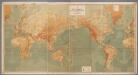
Weltkarte zur Übersicht der Meerestiefen & Höhenschichten, mit Angabe der unterseeischen Telegraphen-Kabel und Überland-Telegraphen, sowie der Kohlenstationen & Docks / bearb. u. gez. v. K. Blume ; gestochen im Atelier v. H. Petters
1 : 28000000 Blume, K.; Petters, H. Berlin : Hydrographisches Amt des Reichs-Marine-Amts [etc.]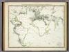
Die Vulkanischen Erscheinungen Der Atlen Welt.
1 : 65000000 Berghaus, Heinrich
Oceanica.
1 : 100000000 Huntington, Nathaniel G. (Nathaniel Gilbert), 1785-1848
Pacific Ocean. Pergamon World Atlas.
Polish Army Topography Service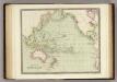
Pacific Ocean.
1 : 55000000 Teesdale, Henry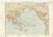
Pazifik
1 : 35000000 Tichý oceán-oblast E. Fastr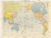
Der Pazifische Raum
1 : 30000000 Tichý oceán Verlagsanstalt List & von Bressensdorf
Pacific Ocean.
1 : 50000000 Hall, S. (Sidney)
Oceana or Pacific Ocean.
1 : 54000000 Tanner, Henry S.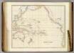
Pacific Ocean.
1 : 40000000 Arrowsmith, John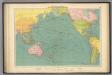
Pacific Ocean.
1 : 40000000 Philip, George
Atlantic Ocean.
1 : 95000000 Huntington, Hezekiah, 1795-1865