Maps of South America

Der Atlantische Ozean
1 : 40000000 Atlantský oceán (oblast) Groll, Max Institut für Meereskunde der Universität
Atlantic Ocean.
1 : 60000000 Smiley, Thomas T.
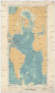
IV. Isothermal chart of the Atlantic Ocean for March and September
Maury, Matthew Fontaine
Picture of the World.
1 : 89000000 Huntington, Hezekiah, 1795-1865
Atlantischer Ocean.
1 : 61000000 Andree, Richard
Atlantic
1 : 60000000 Andree, Richard; Times (London, England)
Atlantic Ocean
1 : 20000000 Atlantský oceán National Geographic Society
Die sichtbare Seite der Mond-Oberflache bei voller Beleuchtung.
1 : 13000000 Stieler, Adolf
Atlantic cables, wireless stations.
1 : 40000000 Philip, George
Composite: Atlantic Ocean.
1 : 25000000 John Bartholomew & Co.
Atlantic Ocean.
1 : 49000000 Goodrich, S.G.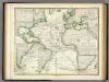
Karte vom Atlantischen Ocean.
1 : 90000000 Berghaus, Heinrich
A generall chart from ENGLAND to cape Bona Espranca with the coast of BRASILE
from The sea-atlas : containing an hydrographical description of most of the sea-coasts of the known parts of the world.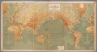
Weltkarte zur Übersicht der Meerestiefen & Höhenschichten, mit Angabe der unterseeischen Telegraphen-Kabel und Überland-Telegraphen, sowie der Kohlenstationen & Docks / bearb. u. gez. v. K. Blume ; gestochen im Atelier v. H. Petters
1 : 28000000 Blume, K.; Petters, H. Berlin : Hydrographisches Amt des Reichs-Marine-Amts [etc.]
America [Karte], in: Gerardi Mercatoris Atlas, sive, Cosmographicae meditationes de fabrica mundi et fabricati figura, S. 547.
1 Karte aus Atlas Mercator, Gerhard Montanus, Petrus
L'Ocean.
1 : 70000000 Buache, Philippe, 1700-1773
Atlantic Ocean.
1 : 45000000 Lizars, W. H. (William Home)

Nova & accuratissima totius terrarum orbis tabula nautica, 2
1 Blatt : 51 x 52 cm R. & I. Ottens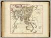
Asia.
1 : 35000000 Cary, John, ca. 1754-1835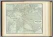
Atlantic Ocean.
1 : 31000000 Johnston, Alexander Keith, 1804-1871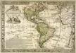
L'Amerique meridionale et septentrionale
1 Karte : Kupferdruck ; 42 x 63 cm, Bildgrösse 48 x 70 cm Desbois; Danet chez Desbois rue S. Jacques a la sphere royale
America.
1 : 75000000 Moll, Herman, d. 1732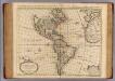
Carte d'Amerique.
1 : 31000000 L'Isle, Guillaume de, 1675-1726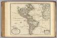
Carte d'Amerique.
1 : 31000000 L'Isle, Guillaume de, 1675-1726
Carte d'Amérique
1 Karte : Kupferdruck ; 46 x 59 cm L'Isle; Buache; Dezauche chez l'auteur rue des Noyers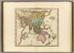
Asia.
1 : 36000000 Tanner, Henry S.
Composite: Asia.
1 : 11000000 Robert Laurie & James Whittle
Carte d'Amerique divisées en ses principales parties
1 : 36000000 par G. de L'Isle, premier geographe du roy rectifieé apres les nouvelles observations du Sr. d'Anville et autres geographes ; J. Condet, sc. A Amsterdam : chez Covens & Mortier & Covens Junior