Maps of Florida
145-46. Ark., Tenn., La., Miss., Fla., Ala., Ga., S.C.
1 : 3000000 Touring club italiano
Southern dominions U.S.
1 : 3100000 Robert Laurie & James Whittle
A GENERAL MAP OF THE SOUTHERN BRITISH COLONIES IN AMERICA
1 : 3000000 Bahamy (souostroví) Romans, Bernard Collet, John Abraham
A General Map of the Southern British Colonies, in America.
1 : 3000000 Robert Sayer and John Bennett (Firm)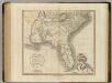
Carolinas, Georgia, Floridas, Bahamas.
1 : 3300000 Cary, John, ca. 1754-1835
S. section U.S.
1 : 4200000 Melish, John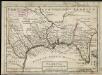
Florida called by ye French Louisiana &c.
1 : 150000 Moll, Herman Bowles, Thomas
Perrine's New Military Map Illustrating The Seat of War.
1 : 2724480 Perrine, Charles O.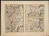
La Florida. Auctore Hieron Chiaves.
When first issued in 1584 as a copper engraving by Ortelius in his Theatrum Orbis Terrarum 1584-1612, this was one of the few sixteenth century maps based on Spanish sources; in this case drawn from reports of Hernando de Soto's expedition through the region. There are three maps on this sheet. The most important map (La Florida) is the first printed map of the southeastern portion of the United States. This influential map provided the foundation cartography for the region, particularly in the depiction of the river system. The map below (Guastecan Reg) combines with La Florida to extend the coastline of the Gulf of Mexico further south. The third is a map of Peru, where De Soto was the first Spaniard to meet Inca Emperor Atahuallpa. In the north of the map of Peru is Aurea Regio, or Kingdom of Gold, a reference to the fabled El Dorado. Text on verso. Chaves, Geronimo, 1523-1574.;Ortelius, Abraham, 1527-1598. Ortelius, Abraham, 1527-1598.
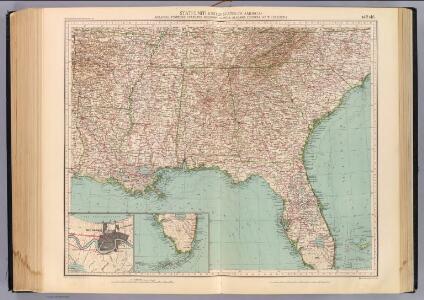
Southern Section of the United States including Florida.
1 : 3928320 Melish, John
Southern Section of the United States including Florida.
1 : 3928320 Melish, John
Virginia, North Carolina, South Carolina, and Georgia.
1 : 6019200 Morse, Jedidiah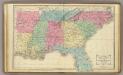
Southern U.S.
1 : 3500000 Cornell, S. S. (Sarah S.)
A general map of the southern British colonies, in America comprehending North and South Carolina, Georgia, East and West Florida, with the neighbouring Indian countries : from the modern surveys of Engineer de Brahm, Capt. Collet, Mouzon & others
1 : 3000000 Romans, Bernard Robert Sayer & John Bennett (Firm)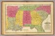
Southern States.
1 : 3700000 Mitchell, Samuel Augustus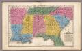
Map of the Southern States.
1 : 3700000 Mitchell, Samuel Augustus
Map of the States of Virginia, North Carolina, South Carolina and Georgia.
1 : 6336000 Morse, Jedidiah
A map of the states of Virginia, North Carolina, South Carolina and Georgia : comprehending the Spanish provinces of east and west Florida : exhibiting the boundaries as fixed by the late treaty of peace between the United States and the Spanish dominions
1 : 6336000 This map depicts the fixed boundaries by a peace treaty between the United States and the Spanish Dominions. Purcell, Joseph John Stockdale
108. Sugar, molasses.
1 : 18000000 Gannett, Henry, 1846-1914; Hewes, Fletcher W.; United States. Census Office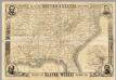
Map Of The Southern States
1 : 3612000 Harper's Weekly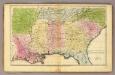
Southern States.
1 : 3600000 Huntington, Francis Junius, 1802-1878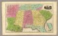
Southern States. (with) South Part of Florida.
1 : 3450000 Smiley, Thomas T.
United States of America, southern part / drawn under the direction of Mr. Pinkerton by L. Hebert ; Neele, sculpt, 352 Strand.
from Whole
A map of East and West Florida, Georgia, and Louisiana, with the islands of Cuba, Bahama, and the countries surrounding the Gulf of Mexico, with the tract of the Spanish galleons, and of our fleets thro' the Straits of Florida, from the best authorities
1 : 5300000 Lodge, John Bew, John
N. & S. Carolina.
1 : 6300000 Grigg, John
War Chart of the Southern States.
War Chart of the Southern States. Published in 1862 by B.B. Russell in Boston, War Chart of the Southern States details the cities, towns, rivers, railroads and marked roads in the Confederacy (with the exception of Texas). The portrait at the bottom right of the map is of the Battle of Hampton Roads, which took place over two days in March 1862 off the Virginian coastline. The naval battle was famous for the fight between the USS Monitor, seen in the foreground of the image, and the CSS Merrimac (sometimes referred to as the CSS Virginia due to the fact that it was built from composite parts of Confederate ships). As can be seen in the image, these ships were ‘ironclads’, built with iron and steel armoured plates. Originally a British naval design, the Civil War witnessed the first clash of these ships at the Battle of Hampton Roads, resulting in worldwide attention on this aspect of naval warfare in America. Arguably the battle between the Monitor and Merrimac was the most famous naval event of the conflict and there are numerous contemporary cultural references to the engagement in items produced during the war. The battle itself was inconclusive, although the Union suffered more casualties than their Confederate counterparts. B.B. Russell
Piedmont Air Line.
1 : 11900000 Piedmont Air Line Railroad Company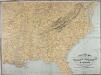
Military Map of the Middle and Southern States
Military Map of the Middle and Southern States, showing the Seat of War during the Great Rebellion in 1861. Drawn and engraved by J. Schedler. This map, published by Schaus, shows the majority of the Confederate states and the Border States of the Union. The map lists the major cities and towns as well as the railroad links across the country.
(Vereinigte Staaten v. Nordamerika) IV.
1 : 8000000 Berghaus, Heinrich; Flemming, Carl; Sohr, Karl