Maps of Coastal Plain

Virginia, North Carolina, South Carolina, and Georgia.
1 : 6019200 Morse, Jedidiah
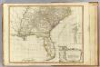
A map of the states of Virginia, North Carolina, South Carolina and Georgia : comprehending the Spanish provinces of east and west Florida : exhibiting the boundaries as fixed by the late treaty of peace between the United States and the Spanish dominions
1 : 6336000 This map depicts the fixed boundaries by a peace treaty between the United States and the Spanish Dominions. Purcell, Joseph John Stockdale
Perrine's New Military Map Illustrating The Seat of War.
1 : 2724480 Perrine, Charles O.
Map of the Atlantic States, showing distances from Washington (in bee line) by 50 mile circles
Colton's Plans Of U.S. Harbors.
Colton, J. H.
The historical war map

Southern section of the United States, including Florida &c. / by John Melish, 1816.
from Parts
American Atlantic ports S.
1 : 5000000 Philip, George
War Maps And Diagrams. Our Naval And Military Operations At A Glance.
1 : 6336000 New York Herald
Map of the Atlantic States, Showing Distances From Washington (In BeeLine) By 50 Mile Circles.
1 : 8236800 Prang, L. & Co.
New map of the states of Georgia South and North Carolina Virginia and Maryland : including the Spanish provinces of West and East Florida from the latest surveys / Cornelius Tieboout, sculp. N. York.
from Charts and maps
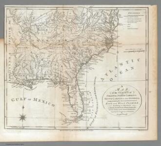
Map of the States of Virginia, North Carolina, South Carolina and Georgia.
1 : 6336000 Morse, Jedidiah
United States E.
1 : 4748000 Johnston, Alexander Keith, 1804-1871
Eastern United States.
1 : 4748000 Johnston, Alexander Keith
Piedmont Air Line.
1 : 11900000 Piedmont Air Line Railroad Company
The Historical War Map.
1 : 3294720 Russell, Benjamin B.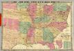
Historical And Military Map Of The Border & Southern States.
1 : 2534400 Phelps & Watson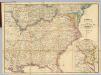
Map Of The Seat Of Civil War In America.
1 : 2534400 Davies & Co.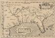
La Florida. [Karte], in: Theatrum orbis terrarum, S. 74.
1 Karte aus Atlas Ortelius, Abraham Vrients, Jan Baptista
United States of America, southern part / drawn under the direction of Mr. Pinkerton by L. Hebert ; Neele, sculpt, 352 Strand.
from Whole
United States of America - East. Pergamon World Atlas.
1 : 5000000 Polish Army Topography Service
A General Map of the Southern British Colonies, in America.
1 : 3000000 Robert Sayer and John Bennett (Firm)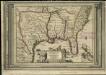
La Floride, suivant les nouvelles observations de Messrs. de l'Academie des Sciences, etc.
1 : 9000000 Aa, Pieter van der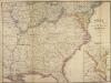
Map of the Seat of Civil War in America, October, 1862
Map of the Seat of Civil War in America, October, 1862. In this map the enlarged segment detailing recent battles focuses on the area along the border of the Union and Confederacy between Maryland and Virginia, particularly from the Chesapeake Bay and Potomac River. Near the top of the enlarged portion, Sharpsburg is labelled, site of the Battle of Antietam in September 1862. Bull Run/Manassas is also marked, along with Fairfax Court House and Centreville, sights that were captured in photographs published by Alexander Gardner. Davies & Co.
Johnson's new rail road & county copper plate map of the Southern States from the latest and best information
1 : 3150000 Johnson, A. J. Johnson & Browning
Eastern United States.
1 : 4748000 Johnston, Alexander Keith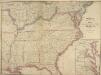
Map of the Seat of Civil War in America, September, 1862
Map of the Seat of Civil War in America, September, 1862. Produced by Davies & Co. in London, this map shows ten of the Confederate states, outlined in red, the Border States of Kentucky and Missouri, which remained within the Union, and lower portion of the Union states, outlined in green. The lower righter corner has an enlarged segment of the country detailing the sites of recent battles around lower Maryland, Washington, D.C. and Virginia. This includes Manassas Junction, where both battles of Bull Run had been fought prior to the map’s publication. Davies & Co.
S. section U.S.
1 : 4200000 Melish, John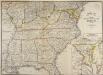
Map of the Seat of Civil War in America
Map of the Seat of Civil War in America. (Enlarged Plan of the Site of the most recent battles). This map, published by Davies & Co. in London, shows the state of America as things stood in July 1863. The Confederate borders are marked in red, the Union borders in green and the Border States in yellow. The separation between Virginia and West Virginia is also depicted. The smaller map in the right hand corner details where the most recent fighting had been, highlighting how volatile the region around the capitals of Washington, D.C., and Richmond were, with this area being the focus of attention in many of the maps produced. It is also possible to see the southern part of Pennsylvania in this map, marking the high–point of General Lee’s troops, who were pushed back out of Union territory after the Battle of Gettysburg in July 1863. Davies & Co.