Maps of Coastal Plain

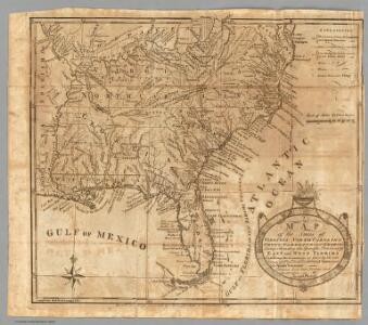
Map of the States of Virginia, North Carolina, South Carolina and Georgia.
1 : 6336000 Morse, Jedidiah
A map of the states of Virginia, North Carolina, South Carolina and Georgia : comprehending the Spanish provinces of east and west Florida : exhibiting the boundaries as fixed by the late treaty of peace between the United States and the Spanish dominions
1 : 6336000 This map depicts the fixed boundaries by a peace treaty between the United States and the Spanish Dominions. Purcell, Joseph John Stockdale
Virginia, North Carolina, South Carolina, and Georgia.
1 : 6019200 Morse, Jedidiah
Perrine's New Military Map Illustrating The Seat of War.
1 : 2724480 Perrine, Charles O.
Piedmont Air Line.
1 : 11900000 Piedmont Air Line Railroad Company
Southern section of the United States, including Florida &c. / by John Melish, 1816.
from Parts
Colton's Plans Of U.S. Harbors.
Colton, J. H.
The historical war map

War Maps And Diagrams. Our Naval And Military Operations At A Glance.
1 : 6336000 New York Herald
American Atlantic ports S.
1 : 5000000 Philip, George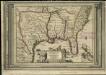
La Floride, suivant les nouvelles observations de Messrs. de l'Academie des Sciences, etc.
1 : 9000000 Aa, Pieter van der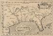
La Florida. [Karte], in: Theatrum orbis terrarum, S. 74.
1 Karte aus Atlas Ortelius, Abraham Vrients, Jan Baptista
A General Map of the Southern British Colonies, in America.
1 : 3000000 Robert Sayer and John Bennett (Firm)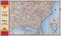
Shell Highway Map Southeastern Section of the United States.
1 : 3231360 Shell Oil Company
Vereinigte Staaten Von Nord-Amerika In 6 Blattern, Bl. 6.
1 : 3700000 Petermann, A.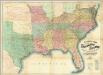
Lloyd's Map Of The Southern States.
1 : 2027520 Lloyd, J. T.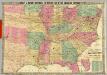
Historical And Military Map Of The Border & Southern States.
1 : 2534400 Phelps & Watson
The Historical War Map.
1 : 3294720 Russell, Benjamin B.
Lloyd's Map of the Southern States
Lloyd's Map of the Southern States showing all the Railroads, their Stations and Distances, also the Counties, Towns, Villages, Harbors, Rivers & Forts. This map was published by J.T. Lloyd in New York in 1861. It details ‘all the railroads, their stations & distances’, as well as the ‘counties, towns, villages, harbors, rivers and forts’ based on the ‘latest Government and other reliable sources’. The map details states beneath the Mason-Dixon line which theoretically separated the northern and southern states. As well as showing the states that made up the eastern side of the Confederacy, the map also shows the Union states of Kentucky, Maryland and Delaware, which, along with Missouri, made up the Border States. Maintaining these states within the Union was a crucial war aim for Lincoln. J.T. Lloyd
S. section U.S.
1 : 4200000 Melish, John
Southern dominions U.S.
1 : 3100000 Robert Laurie & James Whittle
United States of America, southern part / drawn under the direction of Mr. Pinkerton by L. Hebert ; Neele, sculpt, 352 Strand.
from Whole
A general map of the southern British colonies, in America comprehending North and South Carolina, Georgia, East and West Florida, with the neighbouring Indian countries : from the modern surveys of Engineer de Brahm, Capt. Collet, Mouzon & others
1 : 3000000 Romans, Bernard Robert Sayer & John Bennett (Firm)
La Floride: suivant les nouvelles observations de Messrs. de l'Academie royale des sciences, etc. augmentées de nouveau. / A Leide, Chez Pierre Vander A.A., avec privilege.
from John H. Levine Collection Pierre Vander A.A.,
Johnson's new rail road & county copper plate map of the Southern States from the latest and best information
1 : 3150000 Johnson, A. J. Johnson & Browning
Southern Section of the United States including Florida.
1 : 3928320 Melish, John
Southern Section of the United States including Florida.
1 : 3928320 Melish, John
Carolinas, Georgia, Floridas, Bahamas.
1 : 3300000 Cary, John, ca. 1754-1835
Map, showing the Distribution of Slaves in the Southern States. Projected and compiled by A. von Steinwehr.
Map, showing the Distribution of Slaves in the Southern States. Projected and compiled by A. von Steinwehr. This map shows the breakdown of slave-ownership by each county with the darker colour indicating a higher percentage of slaves. The map includes a smaller depiction of where the majority of cotton and sugar production occurred. The map thus shows the extent of the slave system before the war. Von Steinwehr was German-born general in the Union Army who fought at many of the war’s prominent battles, including the First Battle of Bull Run and the Battle of Gettysburg. Alongside fighting, he was a keen cartographer, as this map demonstrates.