Maps of Texas

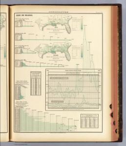
108. Sugar, molasses.
1 : 18000000 Gannett, Henry, 1846-1914; Hewes, Fletcher W.; United States. Census Office
Florida called by ye French Louisiana &c.
1 : 150000 Moll, Herman Bowles, Thomas
Map of the United States of North America / compiled from the latest and most authentic information by David H. Vance ; engraved by J.H. Young.
From Whole
La Florida. Auctore Hieron Chiaves.
When first issued in 1584 as a copper engraving by Ortelius in his Theatrum Orbis Terrarum 1584-1612, this was one of the few sixteenth century maps based on Spanish sources; in this case drawn from reports of Hernando de Soto's expedition through the region. There are three maps on this sheet. The most important map (La Florida) is the first printed map of the southeastern portion of the United States. This influential map provided the foundation cartography for the region, particularly in the depiction of the river system. The map below (Guastecan Reg) combines with La Florida to extend the coastline of the Gulf of Mexico further south. The third is a map of Peru, where De Soto was the first Spaniard to meet Inca Emperor Atahuallpa. In the north of the map of Peru is Aurea Regio, or Kingdom of Gold, a reference to the fabled El Dorado. Text on verso. Chaves, Geronimo, 1523-1574.;Ortelius, Abraham, 1527-1598. Ortelius, Abraham, 1527-1598.
Southern Section of the United States including Florida.
1 : 3928320 Melish, John
Southern Section of the United States including Florida.
1 : 3928320 Melish, John
Texas. Kentucky. Tennessee.
1 : 3743000 Gray, Ormando Willis
145-46. Ark., Tenn., La., Miss., Fla., Ala., Ga., S.C.
1 : 3000000 Touring club italiano
A GENERAL MAP OF THE SOUTHERN BRITISH COLONIES IN AMERICA
1 : 3000000 Bahamy (souostroví) Romans, Bernard Collet, John Abraham
U.S. West of Mississippi R. 6.
1 : 2000000 Freyhold, Edward; Warren, Gouverneur Kemble, 1830-1882; United States. Army. Corps of Engineers
A map of East and West Florida, Georgia, and Louisiana, with the islands of Cuba, Bahama, and the countries surrounding the Gulf of Mexico, with the tract of the Spanish galleons, and of our fleets thro' the Straits of Florida, from the best authorities
1 : 5300000 Lodge, John Bew, John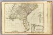
Southern dominions U.S.
1 : 3100000 Robert Laurie & James Whittle
S. section U.S.
1 : 4200000 Melish, John
A General Map of the Southern British Colonies, in America.
1 : 3000000 Robert Sayer and John Bennett (Firm)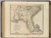
Carolinas, Georgia, Floridas, Bahamas.
1 : 3300000 Cary, John, ca. 1754-1835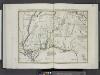
Luigiana Inglese, colla parte Occidentale, della Florida, della Georgia, e Carolina Merid[i]onale.
from Le colonie unite dell' America settentrle : di nuova projezione a s.s.e.e. li Signori Riformatori dello Studio di Padova.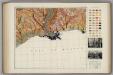
Soil Map of the United States, Section 10. Atlas of American Agriculture.
1 : 2500000 Marbut, Curtis F.
Alabama, Georgia, Sud Carolina und Florida.
1 : 3400000 Lange, Henry, 1821-1893.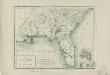
Carte de la Floride et de la Georgie
1 : 3500000 Tardieu, P. F. (Pierre François), 1757-1822 P.G. Chanlaire et E. Mentelle
AutoTrails Map, Texas, Oklahoma, Louisiana, Arkansas.
1 : 1951000 Rand McNally and Company
Georgia, Alabama, and Florida.
1 : 3623775 Fisher, Richard Swainson
United States ... South Central Section.
1 : 2851200 Fullarton, A. & Co.
Florida, Georgia, and South Carolina.
1 : 3000000 Lloyd, H.H.
Florida, Georgia, and South Carolina.
1 : 3000000 Walling, H. F.
A general map of the southern British colonies, in America comprehending North and South Carolina, Georgia, East and West Florida, with the neighbouring Indian countries : from the modern surveys of Engineer de Brahm, Capt. Collet, Mouzon & others
1 : 3000000 Romans, Bernard Robert Sayer & John Bennett (Firm)
Southern U.S.
1 : 3500000 Cornell, S. S. (Sarah S.)
States Of South Carolina, Georgia, Alabama, And Florida.
1 : 3453120 Rogers, Henry Darwin
Shell Sectional Map No. 5 - Southeastern States.
1 : 1710720 Shell Oil Company
Eastern Texas.
1 : 1530000 Rand McNally and Company
J. De Cordova's Map Of The State Of Texas.
1 : 1180000 G.W. & C.B. Colton & Co.