Maps of Nova Scotia
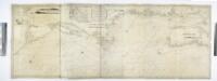
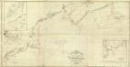
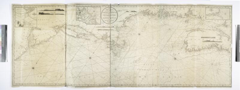
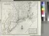
A new chart of the coast of America from Philadelphia to Halifax Harbor / by Wm. Heather, 1809; Stephenson, engraver.
from Whole William Heather,
Nova Anglia, Novum Belgium et Virginia
A map of New England, New York, New Jersey and Pensilvania / by H. Moll geographer.
from An historical account of the incorporated Society for the Propagation of the Gospel in Foreign Parts. Containing their foundation, proceedings and the success of their missionaries in the British Colonies, to the year 1728. By David Humphreys.
Map of railways in the New England states : engraved expressly for Snow's pathfinder railway guide
Geo. K. Snow & Hapgood (Firm) Geo. K. Snow & Hapgood
Tierra nveva.
from Charts and maps
Carte réduite du Nord des Etat-Unis avec l'intérieur du pays, pour servirà l'intelligence de cette histoire.
from Histoire de la derniere guerre, entre la Grande-Bretagne, et les États-Unis de l'Amérique, la France, l'Espagne et la Hollande, depuis son commencement en 1775, jusqu'a sa fin en 1783 ...
Carte réduite des côtes orientales de l'Amérique septentrionale: contenant celles des provinces de New-York et de la Nouvelle Angleterre, celles de l'Acadie ou Nouvelle Ecosse de l'Île Royale de l'Île St. Jean avec l'intérieur du pays / dressée au Dépôt général des cartes, plans et journaux de la marine, pour le service des vaisseaux du roi, par ordre de M. de Sartine, conseiller d'état, ministre et secrétaire d'état ayant le département de la marine; Petit, sculp.
from Parts M. de Sartine,
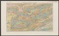
G. Woolworth Colton's railroad, township & distance map of New England : with adjacent portions of New York, Canada & New Brunswick
1 : 900000 Colton, G. Woolworth (George Woolworth), 1827-1901 G. Woolworth Colton
Map showing the Portland & Rochester railroad and its connections
1 : 900000 G.W. & C.B. Colton & Co G.W. & C.B. Colton & Co.


Belgii novi, angliae novae, et partis Virginiae : novissima delineatio
1 : 2450000 Jansson, Jan, 1588-1664 Ioannes Ianssonius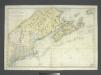
Carte réduite des côtes orientales de l'Amérique septentrionale: contenant celles des provinces de New-York et de la Nouvelle Angleterre, celles de l'Acadie ou Nouvelle Ecosse, de l'Île Royale de l'Île St. Jean, avec l'intérieur du pays dressée au Dépôt général des cartes, plans et journaux de la marine, pour le service des vaisseaux du roi, par ordre de M. de Sartine, conseiller d'Etat, ministre et secretaire d'Etat ayant le département de la marine / Petit, sculp.
from John H. Levine Collection M. de Sartine,
Recens edita totius Novi Belgii in America Septentrionali siti
1 : 2250000 Seutter, Matthaeus, 1678-1756 Matthaei Seutteri
Totius Neobelgii nova et accuratissima tabula / [Hugo Allardt]
1 : 2500000 Annotatie: Lit.: The map collectors' circle, no. 24 (1965); Oorspr. uitg.: [Amsterdam] : Hugo Allardt, [ca. 1656] Allardt, Hugo [Amsterdam : Hugo Allardt excut.]
Novi Belgii Novaeque Angliae nec non partis Virginiae tabula : multis in locis emendata
1 : 2250000 Visscher, Nicolaes, 1649-1702 Ex officina N. Visscher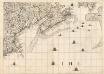
A Map of the British Empire in America. (Sheet 7).
1 : 2000000 Popple, Henry
Novi Belgii Novaeque Angliae nec non partis Virginiae tabula multis in locis emendata
1 : 2000000 a Nicolao Joannis Visschero [S.l.] : [s.n.]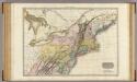
United States of America, northern part.
1 : 2100000 Pinkerton, John, 1758-1826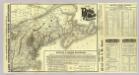
Map Boston & Maine Railroad.
1 : 2192000 Boston and Maine Railroad
Map Boston & Maine Railroad.
1 : 2471040 Boston and Maine Railroad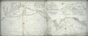
A new chart of America with the harbors of New York, Boston, &c / drawn from the latest authorities by W. Heather, 1799 ; Stephenson sculp.
from Charts and maps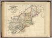
States Of Maine, N. Hampshire, Vermont, Massachusetts, Rhode Island, Connecticut, New York, Pennsylvania, And New Jersey.
1 : 3453120 Rogers, Henry Darwin
197-198. United States of America, North East. The World Atlas.
1 : 2500000 USSR (Union of Soviet Socialist Republics).
Northern provinces of the United States
Nova Belgica Et Anglia Nova [Karte], in: Le théâtre du monde, ou, Nouvel atlas contenant les chartes et descriptions de tous les païs de la terre, Bd. 2, S. 303.
1 Karte aus Atlas Blaeu, Willem Janszoon und Blaeu, Joan Blaeu, Willem Janszoon
Nova Belgica Et Anglia Nova [Karte], in: Novus Atlas, das ist, Weltbeschreibung, Bd. 2, S. 306.
1 Karte aus Atlas Blaeu, Joan Blaeu, Willem Janszoon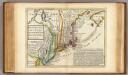
New England, New York, New Jersey and Pensilvania.
1 : 3700000 Moll, Herman, d. 1732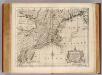
N.J., Pa., N.Y. & New England.
1 : 2200000 Bowen, Emanuel