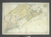
Maps of Les Laurentides
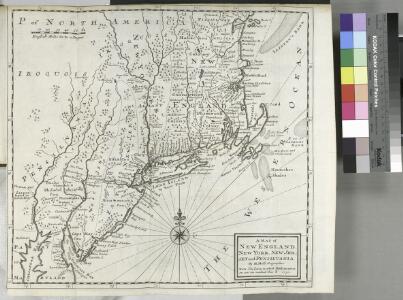
A map of New England, New York, New Jersey and Pensilvania / by H. Moll geographer.
from An historical account of the incorporated Society for the Propagation of the Gospel in Foreign Parts. Containing their foundation, proceedings and the success of their missionaries in the British Colonies, to the year 1728. By David Humphreys.
(East sheet) Map of the Provinces of Upper & Lower Canada with parts of the United States of America &c.
1 : 2300000 Faden, William, 1750?-1836
Sectional map indicating main automobile roads between Canada and United States
1 : 1900800 Kanada východní National Development Bureau
Canada, Louisiane et terres angloises / par le Sr. d'Anville ...
from Parts
Canada &c.
1 : 7350000 Lucas, Fielding Jr.
Central Vt. RR. excursion routes.
1 : 3830000 Central Vermont Railroad Company
G. Woolworth Colton's railroad, township & distance map of New England : with adjacent portions of New York, Canada & New Brunswick
1 : 900000 Colton, G. Woolworth (George Woolworth), 1827-1901 G. Woolworth Colton
A map of ye English Empire in ye continent of America: viz Virginia, Maryland, Carolina, New York, New Iarsey, New England, Pennsilvania / W. Binneman sculpsit.
from Parts W. Binneman,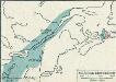
[Québec]
1 : 30000000 Québec
Northern provinces of the United States / drawn & engraved for Thomson's New general atlas, 1817 ; Hewitt Sc. ...
from Charts and maps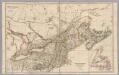
Upper Canada &c.
1 : 2154240 Arrowsmith, John
Carte réduite des côtes orientales de l'Amérique septentrionale: contenant celles des provinces de New-York et de la Nouvelle Angleterre, celles de l'Acadie ou Nouvelle Ecosse de l'Île Royale de l'Île St. Jean avec l'intérieur du pays / dressée au Dépôt général des cartes, plans et journaux de la marine, pour le service des vaisseaux du roi, par ordre de M. de Sartine, conseiller d'état, ministre et secrétaire d'état ayant le département de la marine; Petit, sculp.
from Parts M. de Sartine,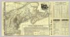
Map Boston & Maine Railroad.
1 : 2192000 Boston and Maine Railroad
Map Boston & Maine Railroad.
1 : 2471040 Boston and Maine Railroad
(Canada, Louisiane et Terres Angloises. Northeast section)
1 : 2900000 Anville, Jean Baptiste Bourguignon d, 1697-1782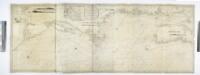
A new chart of the coast of America from Philadelphia to Halifax Harbor / by Wm. Heather, 1809; Stephenson, engraver.
from Whole William Heather,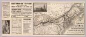
Chicago & Grand Trunk R'y.
1 : 3830000 Chicago and Grand Trunk Railway Company
Carte réduite du Nord des Etat-Unis avec l'intérieur du pays, pour servirà l'intelligence de cette histoire.
from Histoire de la derniere guerre, entre la Grande-Bretagne, et les États-Unis de l'Amérique, la France, l'Espagne et la Hollande, depuis son commencement en 1775, jusqu'a sa fin en 1783 ...
Lower Canada.
1 : 2200000 Arrowsmith, John
Map Of The Provinces Of Canada.
1 : 887040 Bouchette, Joseph
Canada East (Lower).
1 : 1750000 Mitchell, Samuel Augustus
Canada East (Lower).
1 : 1750000 Mitchell, Samuel Augustus
The province of Canada
Kanada Wyld, James James Wyld
Upper Or Western And Lower Or Eastern Canada.
1 : 3453120 Rogers, Henry Darwin
Quebec, New Brunswick, Nova Scotia, Prince Edward Id., Newfoundland.
1 : 2217600 Stanford, Edward
Map, showing the commercial position of Portland
Map, showing the commercial position of Portland ... and its connection by lines of steamboat and railway with Europe, the British Provinces and the United States. Drawn and engraved for the State of Maine Newspaper. A.C. Morton, Engineer. (Map, showing the Plan for shortening the Transit between New York and London.) J.B. Cummings.
Map of railways in the New England states : engraved expressly for Snow's pathfinder railway guide
Geo. K. Snow & Hapgood (Firm) Geo. K. Snow & Hapgood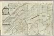
An exact chart of the River St. Laurence.
1 : 695000 Jefferys, Thomas
Map showing the Portland & Rochester railroad and its connections
1 : 900000 G.W. & C.B. Colton & Co G.W. & C.B. Colton & Co.