Maps of Nova Scotia

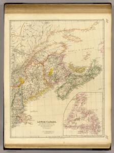
Lower Canada.
1 : 2200000 Arrowsmith, John
Lower Canada ... and a large portion of the United States.
1 : 2154240 Arrowsmith, John
Quebec, New Brunswick, Nova Scotia, Prince Edward Id., Newfoundland.
1 : 2217600 Stanford, Edward
(East sheet) Map of the Provinces of Upper & Lower Canada with parts of the United States of America &c.
1 : 2300000 Faden, William, 1750?-1836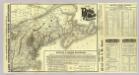
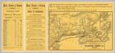
Map Boston & Maine Railroad.
1 : 2192000 Boston and Maine Railroad
Map Boston & Maine Railroad.
1 : 2471040 Boston and Maine Railroad
Nova Scotia, Cape Britain.
1 : 1900000 Jefferys, Thomas
Canada, New Brunswick, Nova Scotia, &c., East Sheet.
1 : 2370000 Black, Adam & Charles
Map, showing the commercial position of Portland
Map, showing the commercial position of Portland ... and its connection by lines of steamboat and railway with Europe, the British Provinces and the United States. Drawn and engraved for the State of Maine Newspaper. A.C. Morton, Engineer. (Map, showing the Plan for shortening the Transit between New York and London.) J.B. Cummings.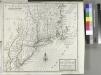
A map of New England, New York, New Jersey and Pensilvania / by H. Moll geographer.
from An historical account of the incorporated Society for the Propagation of the Gospel in Foreign Parts. Containing their foundation, proceedings and the success of their missionaries in the British Colonies, to the year 1728. By David Humphreys.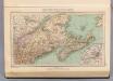
129. Maine, Nova Scotia, New Brunswick, Quebec.
1 : 3000000 Touring club italiano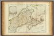
A New Map of Nova Scotia, and Cape Breton Island.
1 : 1900000 Jefferys, Thomas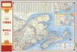
Various Regions and Cities in and around Maine including Canadian Maritime Provinces.
Shell Oil Company
County map of Nova Scotia, New Brunswick, Cape Breton, and Prince Edward's Islands; City and harbor of Halifax [inset].
from Mitchell's new general atlas, containing maps of the various countries of the world, plans of cities, etc., embraced in fifty-three quarto maps., forming a series of eighty four maps and plans, together with valuable statistical tables.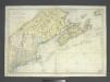
Carte réduite des côtes orientales de l'Amérique septentrionale: contenant celles des provinces de New-York et de la Nouvelle Angleterre, celles de l'Acadie ou Nouvelle Ecosse, de l'Île Royale de l'Île St. Jean, avec l'intérieur du pays dressée au Dépôt général des cartes, plans et journaux de la marine, pour le service des vaisseaux du roi, par ordre de M. de Sartine, conseiller d'Etat, ministre et secretaire d'Etat ayant le département de la marine / Petit, sculp.
from John H. Levine Collection M. de Sartine,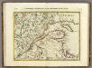
Parte Orientale del Canada, Nuova Scozia Settentrionale, e Parte di Labrador.
1 : 2100000 Zatta, Antonio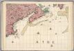
A Map of the British Empire in America. (Sheet 7).
1 : 2000000 Popple, Henry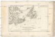
Isle et banc de Terre-Neuve, Isle Royale et Isle St. Jean, avec l'Acadie ou la Nouvelle Ecosse
1 : 5560000 Akádie Bonne, Rigobert André
Carte réduite des côtes orientales de l'Amérique septentrionale: contenant celles des provinces de New-York et de la Nouvelle Angleterre, celles de l'Acadie ou Nouvelle Ecosse de l'Île Royale de l'Île St. Jean avec l'intérieur du pays / dressée au Dépôt général des cartes, plans et journaux de la marine, pour le service des vaisseaux du roi, par ordre de M. de Sartine, conseiller d'état, ministre et secrétaire d'état ayant le département de la marine; Petit, sculp.
from Parts M. de Sartine,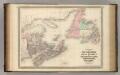
New Brunswick and Nova Scotia.
1 : 2300000 Johnson, A.J.
New Brunswick and Nova Scotia.
1 : 2300000 Johnson, A.J.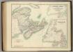
Eastern Canada.
1 : 2065500 Johnston, Alexander Keith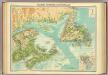
Maritime Provinces & Newfoundland.
1 : 2500000 John Bartholomew & Co.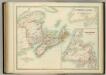
Eastern Canada.
1 : 2065500 Johnston, W. & A.K.
New Brunswick, Nova Scotia and Prince Edward Island.
1 : 2700000 Colton, G.W.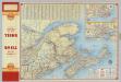
Shell Maritime Provinces.
1 : 2090880 Shell Oil Company
The district of Main : from the latest surveys
1 : 2900000 Carleton, Osgood, 1742-1816
The district of Main : from the latest surveys
1 : 2800000 Carleton, Osgood, 1742-1816 by Isaiah Thomas and Ebenezer T. Andrews
New Map of Nova Scotia, New Brunswick and Cape Breton.
1 : 4200000 Morse, Jedidiah