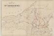
Maps of New York

Carte réduite du Nord des Etat-Unis avec l'intérieur du pays, pour servirà l'intelligence de cette histoire.
from Histoire de la derniere guerre, entre la Grande-Bretagne, et les États-Unis de l'Amérique, la France, l'Espagne et la Hollande, depuis son commencement en 1775, jusqu'a sa fin en 1783 ...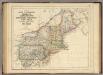
States Of Maine, N. Hampshire, Vermont, Massachusetts, Rhode Island, Connecticut, New York, Pennsylvania, And New Jersey.
1 : 3453120 Rogers, Henry Darwin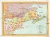
Sectional map indicating main automobile roads between Canada and United States
1 : 1900800 Kanada východní National Development Bureau
Carte réduite des côtes orientales de l'Amérique septentrionale: contenant celles des provinces de New-York et de la Nouvelle Angleterre, celles de l'Acadie ou Nouvelle Ecosse de l'Île Royale de l'Île St. Jean avec l'intérieur du pays / dressée au Dépôt général des cartes, plans et journaux de la marine, pour le service des vaisseaux du roi, par ordre de M. de Sartine, conseiller d'état, ministre et secrétaire d'état ayant le département de la marine; Petit, sculp.
from Parts M. de Sartine,
G. Woolworth Colton's railroad, township & distance map of New England : with adjacent portions of New York, Canada & New Brunswick
1 : 900000 Colton, G. Woolworth (George Woolworth), 1827-1901 G. Woolworth Colton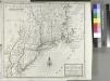
A map of New England, New York, New Jersey and Pensilvania / by H. Moll geographer.
from An historical account of the incorporated Society for the Propagation of the Gospel in Foreign Parts. Containing their foundation, proceedings and the success of their missionaries in the British Colonies, to the year 1728. By David Humphreys.
Tierra nveva.
from Charts and maps
Map showing the Portland & Rochester railroad and its connections
1 : 900000 G.W. & C.B. Colton & Co G.W. & C.B. Colton & Co.
Railway map of routes to the White Mountains
Boardman, Harvey J.H. Bufford's Lith.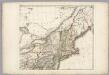
Sheet 2: United States of Nth. America.
1 : 1584000 Tardieu, P.F.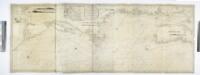
A new chart of the coast of America from Philadelphia to Halifax Harbor / by Wm. Heather, 1809; Stephenson, engraver.
from Whole William Heather,
United States 4.
1 : 1750000 Arrowsmith, Aaron
Map of railways in the New England states : engraved expressly for Snow's pathfinder railway guide
Geo. K. Snow & Hapgood (Firm) Geo. K. Snow & Hapgood
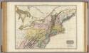
Northern provinces of the United States

Belgii novi, angliae novae, et partis Virginiae : novissima delineatio
1 : 2450000 Jansson, Jan, 1588-1664 Prostant ... apud Petrum Schenk, et Gerardum Valk
Lloyd's Railroad, Telegraph & Express Map of the Eastern States
Lloyd's Railroad, Telegraph & Express Map of the Eastern States to accompany Lloyd's Railroad, Telegraph & Express Map of the United States and Canadas. This map shows the communication lines of the eastern states of the Union as they existed in 1863. Reliable communication networks were vital during the war to send troops and messages from one theatre of conflict to another. The map also lists the position of telegraph stations close to the offices of Express companies which provided the main form of travel in this period of American history.
New England and New York.
1 : 3000000 Lloyd, H.H.
New England and New York.
1 : 3000000 Walling, H. F.
N.E. United States.
1 : 2150000 Cornell, S. S. (Sarah S.)
Map of the Troy & Greenfield Rail Road and its connections
Edwards, A. F B.W. Thayer & Co.'s Lith.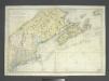
Carte réduite des côtes orientales de l'Amérique septentrionale: contenant celles des provinces de New-York et de la Nouvelle Angleterre, celles de l'Acadie ou Nouvelle Ecosse, de l'Île Royale de l'Île St. Jean, avec l'intérieur du pays dressée au Dépôt général des cartes, plans et journaux de la marine, pour le service des vaisseaux du roi, par ordre de M. de Sartine, conseiller d'Etat, ministre et secretaire d'Etat ayant le département de la marine / Petit, sculp.
from John H. Levine Collection M. de Sartine,
197-198. United States of America, North East. The World Atlas.
1 : 2500000 USSR (Union of Soviet Socialist Republics).
Nova Anglia, Novum Belgium et Virginia

United States.
1 : 3380000 Sharpe, J.
Recens edita totius Novi Belgii in America Septentrionali siti
1 : 2250000 Seutter, Matthaeus, 1678-1756 Matthaei Seutteri
United States of America, northern part.
1 : 2100000 Pinkerton, John, 1758-1826
Canada.
1 : 4100000 Hughes, William


