Maps of New York

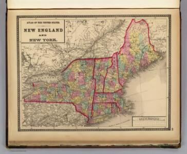
New England and New York.
1 : 3000000 Lloyd, H.H.
New England and New York.
1 : 3000000 Walling, H. F.
United States 4.
1 : 1750000 Arrowsmith, Aaron
States Of Maine, N. Hampshire, Vermont, Massachusetts, Rhode Island, Connecticut, New York, Pennsylvania, And New Jersey.
1 : 3453120 Rogers, Henry Darwin
Map of the Troy & Greenfield Rail Road and its connections
Edwards, A. F B.W. Thayer & Co.'s Lith.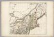
Sheet 2: United States of Nth. America.
1 : 1584000 Tardieu, P.F.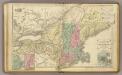
N.E. United States.
1 : 2150000 Cornell, S. S. (Sarah S.)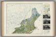
Soil Map of the United States, Section 1. Atlas of American Agriculture.
1 : 2500000 Marbut, Curtis F.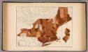
101. Consumption NY, NJ, New England.
1 : 3000000 Gannett, Henry, 1846-1914; United States. Census Office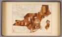
109. Typhoid fever NY, NJ, New England.
1 : 3000000 Gannett, Henry, 1846-1914; United States. Census Office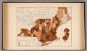
105. Diphtheria, croup NY, NJ, New England.
1 : 3000000 Gannett, Henry, 1846-1914; United States. Census Office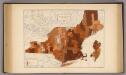
107. Influenza NY, NJ, New England.
1 : 3000000 Gannett, Henry, 1846-1914; United States. Census Office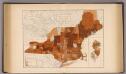
103. Cancer, tumor NY, NJ, New England.
1 : 3000000 Gannett, Henry, 1846-1914; United States. Census Office
197-198. United States of America, North East. The World Atlas.
1 : 2500000 USSR (Union of Soviet Socialist Republics).
United States.
1 : 3380000 Sharpe, J.
Northern provinces of the United States

Map of the New York Central & Hudson River and Boston & Albany Railroads

Carte réduite du Nord des Etat-Unis avec l'intérieur du pays, pour servirà l'intelligence de cette histoire.
from Histoire de la derniere guerre, entre la Grande-Bretagne, et les États-Unis de l'Amérique, la France, l'Espagne et la Hollande, depuis son commencement en 1775, jusqu'a sa fin en 1783 ...
Lloyd's Railroad, Telegraph & Express Map of the Eastern States
Lloyd's Railroad, Telegraph & Express Map of the Eastern States to accompany Lloyd's Railroad, Telegraph & Express Map of the United States and Canadas. This map shows the communication lines of the eastern states of the Union as they existed in 1863. Reliable communication networks were vital during the war to send troops and messages from one theatre of conflict to another. The map also lists the position of telegraph stations close to the offices of Express companies which provided the main form of travel in this period of American history.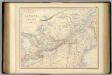
British North America. Sheet II, West.
1 : 2407680 Fullarton, A. & Co.
Nova Anglia Septentrionali Americae implantata Anglorumque coloniis florentissima geographicè exhibita

Carte réduite des côtes orientales de l'Amérique septentrionale: contenant celles des provinces de New-York et de la Nouvelle Angleterre, celles de l'Acadie ou Nouvelle Ecosse de l'Île Royale de l'Île St. Jean avec l'intérieur du pays / dressée au Dépôt général des cartes, plans et journaux de la marine, pour le service des vaisseaux du roi, par ordre de M. de Sartine, conseiller d'état, ministre et secrétaire d'état ayant le département de la marine; Petit, sculp.
from Parts M. de Sartine,
Railway map of routes to the White Mountains
Boardman, Harvey J.H. Bufford's Lith.
Totius Neobelgii nova et accuratissima tabula / [Hugo Allardt]
1 : 2500000 Annotatie: Lit.: The map collectors' circle, no. 24 (1965); Oorspr. uitg.: [Amsterdam] : Hugo Allardt, [ca. 1656] Allardt, Hugo [Amsterdam : Hugo Allardt excut.]
Map exhibiting the rail road, canal, lake and river routes from New York and Boston to the west, via Ogdensburgh, Buffalo and Sacket's Harbor, N.Y
1 : 1150000 J.H. Bufford & Co J.H. Bufford & Co. Lith.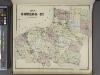
Map of Oswego Co.
from New topographical atlas of Oswego County, New York : from actual surveys especially for this atlas.
Belgii novi, angliae novae, et partis Virginiae : novissima delineatio
1 : 2450000 Jansson, Jan, 1588-1664 Ioannes Ianssonius
Scene of Operations of the Northern Army.
1 : 1950000 Marshall, John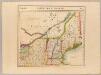
Partie des Etats-Unis. Amer. Sep. 43.
1 : 1641836 Vandermaelen, Philippe, 1795-1869