Maps of Una-Sana Canton

Gracac und Ermain.; Spezialkarte der osterreichisch-ungarischen Monarchie.
from Spezialkarte der osterreichisch-ungarischen Monarchie. Austro-Hungarian Monarchy. Militärgeographisches Institut.,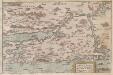
Zarae, et Sebenici Descriptio
Zadar (Region) Lazius, Wolfgang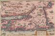
Zarae, Et Sebenici Descriptio [Karte], in: Theatrum orbis terrarum, S. 262.
1 Karte aus Atlas Ortelius, Abraham
Karte vom Liccaner Grenz Regiment
1 : 105000 Chorvatsko Kossovich, Mathias Kaiser, J.F.
Cpljet
1 : 200000 Bosanska Kostajnica (Bosna a Hercegovina) Kartografska radionica
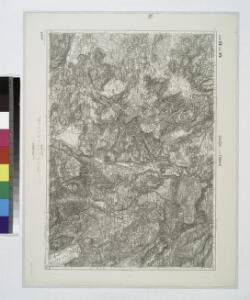
Dolnji Lapac und Kulen-Vakuf.
from Spezialkarte der osterreichisch-ungarischen Monarchie.
Vrtoce DL. und Ribnikgrn.
from Spezialkarte der osterreichisch-ungarischen Monarchie.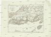
Westlicher Theil von Dalmatien
1 : 450000 Chorvatsko Santini, P. Engelman, J. W. F. A. Schraembl
Westlicher Theil von Dalmatien
1 : 445000 Chorvatsko Santini, P. Engelman, J. W. F. A. Schraembl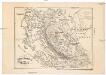
Ostrovy Quarnerské a Velebit
1 : 913000 Dalmácie (Chorvatsko)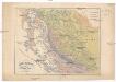
Ostrovy Quarnerské a Velebit
1 : 913000 Dalmácie (Chorvatsko)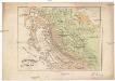
Ostrovy Quarnerské a Velebit
1 : 913000 Dalmácie (Chorvatsko)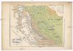
Ostrovy Quarnerské a Velebit
1 : 913000 Dalmácie (Chorvatsko)
Iadera, Sicum et Aenona Vulgo Zara, Sibenico et Nona cum Insulis adiacentibus. in Parte Dalmatiae Boreali. [Karte], in: Het vijfde Deel Des Grooten Atlas : Vervatende De Water-Weereld, S. 234.
1 Karte aus Atlas Jansson, Jan Jansson, Jan
Iadera, Sicum et Aenona Vulgo Zara, Sibenico et Nona cum Insulis adjacentibus. in Parte Dalmatiae Boreali. [Karte], in: Novus atlas absolutissimus, Bd. 9, S. 314.
1 Karte aus Atlas Janssonius Offizin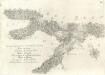
Accuratissima totius Savi area, in VI. Tabulis Geographicis repreasentata ab utraqve sua Origine usqve ad Illapsum in Danubium: nec non totius Labaci Fluvii una cum incurrentibus Fluminibus et adjacentibus Locis ac confiniis].
Mollova mapová sbírka Renner, F. C. Kaltschmidt, Abraham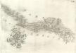
Pars Regni Croatiae
Mollova mapová sbírka Renner, F. C. Kaltschmidt, Abraham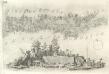
Pars Styriae Pars Regni [Ca]rnioliae Croatiae
Mollova mapová sbírka Renner, F. C. Kaltschmidt, Abraham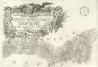
Ausführlicher Plan des gantzen Sau-Stroms, in VI. Tabellen vorgestellet, von seinen beyden Ursprüngen bis Zum Einfall in die Donau: wie auch des gantzen Laybaci-Flusses, sambt allen darein-fallengen Elüssen und daran liegenden Orthern, und Gränitzen.
Mollova mapová sbírka Renner, F. C. Kaltschmidt, Abraham
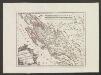
Charte des nordwestlichen Theil von Dalmatien
Dalmácie (Chorvatsko) Verlage der Kunst und Industrie
Partie de la Dalmatie du nord ouest
Dalmácie (Chorvatsko) im Verlage des Kunst und Industrie Comptoirs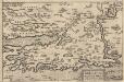
Zarae, Et Sebenici Descriptio [Karte], in: Theatrum orbis terrarum, S. 357.
1 Karte aus Atlas Ortelius, Abraham Vrients, Jan Baptista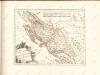
Der Noerdliche Theil Des Königreichs Dalmatien
1 : 1000000 Dalmatien
Sclavonia. Bosnia
Mollova mapová sbírka Hoffmann, Johannes Hoffmann, Johann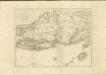

Vermehrte und Verbesserte Landkarten des Königreichs Ungarn :
1 : 500000 Mollova mapová sbírka Stier, Martin Böner, Johann-Alexander Endter, Martin
Croatia
Mollova mapová sbírka Hoffmann, Johannes Hoffmann, Johann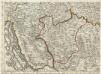
Augustissimo Romanor. Imperatori Iosepho I. Hungaria Regi Invictissimo Mappam Hanc Regni Hungariae
1 : 540000 Mollova mapová sbírka Müller, Johann Christoph
Zagreb, Brod, Osijek, Glina, Knin, Sarajevo
1 : 750000 Glina (Chorvatsko) Cronenberg, E. K. u. k. Militärgeographisches Institut