Maps of Zadar County

Iadera, Sicum et Aenona Vulgo Zara, Sibenico et Nona cum Insulis adjacentibus. in Parte Dalmatiae Boreali. [Karte], in: Novus atlas absolutissimus, Bd. 9, S. 314.
1 Karte aus Atlas Janssonius Offizin
Iadera, Sicum et Aenona Vulgo Zara, Sibenico et Nona cum Insulis adiacentibus. in Parte Dalmatiae Boreali. [Karte], in: Het vijfde Deel Des Grooten Atlas : Vervatende De Water-Weereld, S. 234.
1 Karte aus Atlas Jansson, Jan Jansson, Jan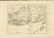
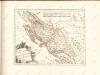
Der Noerdliche Theil Des Königreichs Dalmatien
1 : 1000000 Dalmatien
Adriatisches Meer, Küstenkarte
1 : 180000 Dugi Otok (Chorvatsko : ostrov) Oesterreicher, Tobias von Hydrographisches Amt der k. u. k. Kriegsmarine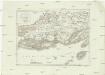
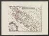
Westlicher Theil von Dalmatien
1 : 450000 Chorvatsko Santini, P. Engelman, J. W. F. A. Schraembl
Westlicher Theil von Dalmatien
1 : 445000 Chorvatsko Santini, P. Engelman, J. W. F. A. Schraembl
Charte des nordwestlichen Theiles von Dalmatien
Dalmácie (Chorvatsko) im Verlage des Kunst und Industrie Comptoirs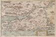
Zarae, et Sebenici Descriptio
Zadar (Region) Lazius, Wolfgang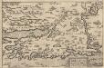
Zarae, Et Sebenici Descriptio [Karte], in: Theatrum orbis terrarum, S. 357.
1 Karte aus Atlas Ortelius, Abraham Vrients, Jan Baptista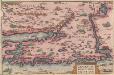
Zarae, Et Sebenici Descriptio [Karte], in: Theatrum orbis terrarum, S. 262.
1 Karte aus Atlas Ortelius, Abraham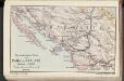
Die adriatische Küste von Zara bis Spalato
1 : 900000 Kroatien Adriaküste
Karte vom Liccaner Grenz Regiment
1 : 105000 Chorvatsko Kossovich, Mathias Kaiser, J.F.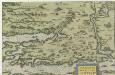
Zarae, Et Sebenici Descriptio
Mollova mapová sbírka Lazius, Wolfgang
Dioecesis Iadrensis
1 : 1850000 Diözese Zadar
Dalmatien
1 : 80000 Dalmácie (Chorvatsko) Oesterreicher, T. Hydrographisches Amt der K. u. k. Kriegsmarine, Seekartendepot
Sebenico und die Krkaseen
1 : 600000 Kroatien Krka-Gebiet Šibenik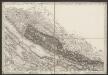
[Umgebung von Starigrad-Paklenica]
Kroatien Dalmatien Bezirk Zadar-Knin Umland
Sale.
from Spezialkarte der osterreichisch-ungarischen Monarchie.
Pago.
from Spezialkarte der osterreichisch-ungarischen Monarchie.
Zaravecchia und Stretto.
from Spezialkarte der osterreichisch-ungarischen Monarchie.
Sebenico und Trau.
from Spezialkarte der osterreichisch-ungarischen Monarchie.
Zara.
from Spezialkarte der osterreichisch-ungarischen Monarchie.
Zuri [Zirije].
from Spezialkarte der osterreichisch-ungarischen Monarchie.
I. Solta.
from Spezialkarte der osterreichisch-ungarischen Monarchie.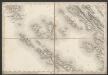
[Umgebung von Olib]
Kroatien Dalmatien Olib (Insel) Umland
Kistanje und Drnis.
from Spezialkarte der osterreichisch-ungarischen Monarchie.
I. St. Andrea.
from Spezialkarte der osterreichisch-ungarischen Monarchie.
![Iadera, Sicum et Aenona Vulgo Zara, Sibenico et Nona cum Insulis adjacentibus. in Parte Dalmatiae Boreali. [Karte], in: Novus atlas absolutissimus, Bd. 9, S. 314.](https://images-2.georeferencer.com/images/iiif/075172792040/full/,300/0/native.jpg)

