Maps of Skhidnytsia

Skole (Galizien).
from Spezialkarte der osterreichisch-ungarischen Monarchie.

Tuchla.
from Spezialkarte der osterreichisch-ungarischen Monarchie.
[Drohobycz]
1 : 75000 Drohobyč (Ukrajina) K. u. k. Militärgeographisches Institut
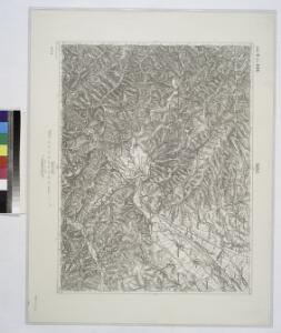
Tuchla
1 : 75000 Ukrajina Vojenský zeměpisný ústav
III. vojenské mapování 4471
1 : 75000
Tuchla
1 : 75000 Woiwodschaft Vorkarpaten Schrift u. Gerippe v. Lieut. Januszewski. Terrainschraffirung v. Oberlt. Türk u. Oberlt. Blaschke
Tuchla
1 : 75000 Ukrajina Blaschke K. u. k. Militärgeographisches Institut
Tuchla
1 : 75000 Ukrajina Blaschke K. u. k. Militärgeographisches Institut
Neubertova generální automapa Republiky československé
1 : 200000 Soukup, Jan V. Neubert a synové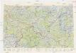
Neubertova generální automapa Republiky československé
1 : 200000 Soukup, Jan V. Neubert a synové
Turka
1 : 75000 Polsko Vojenský zeměpisný ústav
Bolechów
1 : 75000 Brunn, L. K. u. k. Militärgeographisches Institut
Turka.; Spezialkarte der osterreichisch-ungarischen Monarchie.
from Spezialkarte der osterreichisch-ungarischen Monarchie. Austro-Hungarian Monarchy. Militärgeographisches Institut.,
III. vojenské mapování 4370
1 : 75000
Drohobycz.; Spezialkarte der osterreichisch-ungarischen Monarchie.
from Spezialkarte der osterreichisch-ungarischen Monarchie. Austro-Hungarian Monarchy. Militärgeographisches Institut.,
Turka
1 : 75000 Turka (Ukraine), Umland Geripp: Obejäger Richter. Terrain: F. Matskássý
Bolechow.; Spezialkarte der osterreichisch-ungarischen Monarchie.
from Spezialkarte der osterreichisch-ungarischen Monarchie. Austro-Hungarian Monarchy. Militärgeographisches Institut.,
Dolina.
from Spezialkarte der osterreichisch-ungarischen Monarchie.
Smorze und Also-Verecke.
from Spezialkarte der osterreichisch-ungarischen Monarchie.
Stary Sambor (Galizien).
from Spezialkarte der osterreichisch-ungarischen Monarchie.
Zydaczow und Stryj.
from Spezialkarte der osterreichisch-ungarischen Monarchie.
Verecki a Smorze
1 : 75000 Ukrajina Vojenský zeměpisný ústav
Dolina
1 : 75000 Ukrajina Ehrenhöfer, W. K. u. k. Militärgeographisches Institut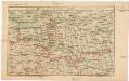
Strecke
Ivano-Frankivsk (Ukrajina) K. k. Österreichische Staatsbahnen
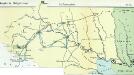
Podkarpatská Rus
1 : 500000 Berehove (Ukrajina) Fastr Eduard
Podkarpatská Rus
1 : 300000 Berehove (Ukrajina) Fastr Eduard
Russia
Mollova mapová sbírka Hoffmann, Johannes Hoffmann, Johann
Ost Galizien
Halič (Polsko a Ukrajina) Liesganig, Joseph m Verlage des Kunst- und Industrie- Comptoirs