Maps of Ivano-Frankivs'k

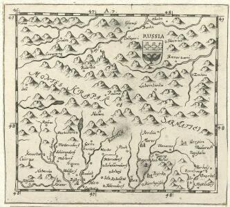
Russia
Mollova mapová sbírka Hoffmann, Johannes Hoffmann, Johann
Vermehrte und Verbesserte Landkarten des Königreichs Ungarn :
1 : 500000 Mollova mapová sbírka Stier, Martin Böner, Johann-Alexander Endter, Martin
Generalkarte von Zentraleuropa

Máramaros vármegye térképe
1 : 500000 Maramureş (Rumunsko) Kogutowicz, Manó Magyar Földrajzi Intézet
Comitat Marmaros
1 : 288000 Maramureş (Rumunsko)
Comitat Marmaros
1 : 280000 Marmarošská Sihoť (Rumunsko : oblast)
C. Marmarus
Rumänien Komitat Marmarosch
Podkarpatská Rus
1 : 500000 Berehove (Ukrajina) Fastr Eduard
Podkarpatská Rus
1 : 300000 Berehove (Ukrajina) Fastr Eduard
Generalkarte von Zentraleuropa
Podkarpatská Rus
1 : 300000 Podkarpatská Rus (Ukrajina) Referát min. veř. prací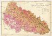
Podkarpatská Rus
1 : 225000 Podkarpatská Rus (Ukrajina) Gregor, František Novotný a Bartošek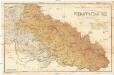
Podkarpatská Rus
1 : 225000 Podkarpatská Rus (Ukrajina) Gregor, František Novotný a Bartošek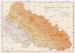
Podkarpatská Rus
1 : 225000 Podkarpatská Rus (Ukrajina) Gregor, František Novotný a Bartošek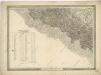
General-Karte des Königreiches Galizien und des Herzogthumes Bukovina


General-Karte des Königreiches Galizien und des Herzogthumes Bukovina

Gorgany Zachodnie
1 : 100000 Lenkiewicz, Adam Książnica-Atlas
Zolkiew (Galizien).
from Spezialkarte der osterreichisch-ungarischen Monarchie.


Řiditelství [sic] státních lesů Rachovo
1 : 75000 Voj. zeměpisný ústav
Brustury
1 : 75000 Ukrajina Vojenský zeměpisný ústav
Korosmezo und Mikuliczyn.
from Spezialkarte der osterreichisch-ungarischen Monarchie.
Magyar-Lapos und Makod.
from Spezialkarte der osterreichisch-ungarischen Monarchie.
Mapa specjalna okolic Lwowa
1 : 100000 Lvov-oblast (Ukrajina) Książnica – Atlas