Maps of Dolyna Raion

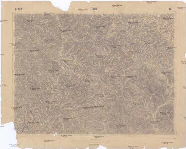
Tuchla
1 : 75000 Ukrajina Vojenský zeměpisný ústav
Tuchla.
from Spezialkarte der osterreichisch-ungarischen Monarchie.
Tuchla
1 : 75000 Woiwodschaft Vorkarpaten Schrift u. Gerippe v. Lieut. Januszewski. Terrainschraffirung v. Oberlt. Türk u. Oberlt. Blaschke
III. vojenské mapování 4471
1 : 75000
Tuchla
1 : 75000 Ukrajina Blaschke K. u. k. Militärgeographisches Institut
Tuchla
1 : 75000 Ukrajina Blaschke K. u. k. Militärgeographisches Institut
Neubertova generální automapa Republiky československé
1 : 200000 Soukup, Jan V. Neubert a synové
Neubertova generální automapa Republiky československé
1 : 200000 Soukup, Jan V. Neubert a synové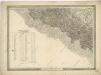
General-Karte des Königreiches Galizien und des Herzogthumes Bukovina


Dolina.
from Spezialkarte der osterreichisch-ungarischen Monarchie.
Skole (Galizien).
from Spezialkarte der osterreichisch-ungarischen Monarchie.
Okormezo (Galizien).
from Spezialkarte der osterreichisch-ungarischen Monarchie.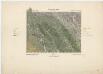
Zone 10, 11, Kol. XXIX, Ökörmezö und Tuchla, uit: [Geologische Specialkarte der im Reichsrathe vertretenen Königreiche und Länder der österreichisch-ungarischen Monarchie] / geologische Aufnahmen der königl. ung. Geologischen Anstalt
1 : 75000 Annotatie: Verantwoordelijkheidsvermelding in 1909 veranderd in: Königliche Ungarische Geologische Reichsanstalt; Sommige bladen in het Frans; Annotatie geografische gegevens: Coördinaten gebaseerd op nulmeridiaan van Ferro (Hierro) Königliche Ungarische Geologische Reichsanstalt; Königliche Ungarische Geologische Anstalt Budapest : [Königliche Ungarische Geologische Anstalt]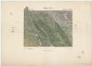
III. vojenské mapování 4571
1 : 75000
Dolina
1 : 75000 Ukrajina Ehrenhöfer, W. K. u. k. Militärgeographisches Institut
Ökörmező
1 : 75000 Transkarpatien, Mizhhir"ya Geripp: Fwk. Heller u. Zivilarb. Melichar. Terrain: Oberlt. Fischer, Assist. Hauk u. Fhr. Wache
Volové
1 : 75000 Ukrajina Vojenský zeměpisný ústav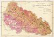
Podkarpatská Rus
1 : 225000 Podkarpatská Rus (Ukrajina) Gregor, František Novotný a Bartošek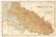
Podkarpatská Rus
1 : 225000 Podkarpatská Rus (Ukrajina) Gregor, František Novotný a Bartošek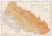
Podkarpatská Rus
1 : 225000 Podkarpatská Rus (Ukrajina) Gregor, František Novotný a Bartošek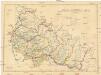
Podkarpatská Rus
1 : 300000 Podkarpatská Rus (Ukrajina) Referát min. veř. prací
Podkarpatská Rus
1 : 500000 Berehove (Ukrajina) Fastr Eduard
Podkarpatská Rus
1 : 300000 Berehove (Ukrajina) Fastr Eduard
Russia
Mollova mapová sbírka Hoffmann, Johannes Hoffmann, Johann
Ost Galizien
Halič (Polsko a Ukrajina) Liesganig, Joseph m Verlage des Kunst- und Industrie- Comptoirs
Vermehrte und Verbesserte Landkarten des Königreichs Ungarn :
1 : 500000 Mollova mapová sbírka Stier, Martin Böner, Johann-Alexander Endter, Martin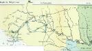
Nr. 6b. Kämpfe in Ostgalizien. Im Dnjestrgebiet
Galizien Weltkrieg <1914-1918>, Ostfront
Tarnopol, Brody, Stryj, Czernowitz
1 : 750000 Brody (Ukrajina) Erben, F. K. u. k. Militärgeographisches Institut
Tarnopol, Brody, Stryj, Czernowitz
1 : 750000 Brody (Ukrajina) Erben, F. K. u. k. Militärgeographisches Institut
Tarnopol, Brody, Stryj, Czernowitz
1 : 750000 K. u. k. militär-geographisches Institut