Maps of Sambir

Stary Sambor (Galizien).
from Spezialkarte der osterreichisch-ungarischen Monarchie.
[Drohobycz]
1 : 75000 Drohobyč (Ukrajina) K. u. k. Militärgeographisches Institut
Sambor.
from Spezialkarte der osterreichisch-ungarischen Monarchie.
III. vojenské mapování 4370
1 : 75000
Turka.; Spezialkarte der osterreichisch-ungarischen Monarchie.
from Spezialkarte der osterreichisch-ungarischen Monarchie. Austro-Hungarian Monarchy. Militärgeographisches Institut.,
Turka
1 : 75000 Turka (Ukraine), Umland Geripp: Obejäger Richter. Terrain: F. Matskássý
Turka
1 : 75000 Polsko Vojenský zeměpisný ústav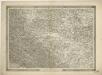
General-Karte des Königreiches Galizien und des Herzogthumes Bukovina

Generalkarte von Zentraleuropa


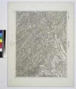
Sambor
1 : 75000 Sambir (Ukrajina) Berger K. u. k. Militärgeographisches Institut
Ustrzyki Dolne
1 : 75000 Polsko jihovýchodní Adler K. u. k. Militärgeographisches Institut
Ustrzyki Dolne.; Spezialkarte der osterreichisch-ungarischen Monarchie.
from Spezialkarte der osterreichisch-ungarischen Monarchie. Austro-Hungarian Monarchy. Militärgeographisches Institut.,
Drohobycz.; Spezialkarte der osterreichisch-ungarischen Monarchie.
from Spezialkarte der osterreichisch-ungarischen Monarchie. Austro-Hungarian Monarchy. Militärgeographisches Institut.,
Skole (Galizien).
from Spezialkarte der osterreichisch-ungarischen Monarchie.
Ruské
1 : 75000 Polsko Vojenský zeměpisný ústav
Zemplénoroszi und Dydiowa
1 : 75000 Chlum K. u. k. Militärgeographisches Institut
Strecke
Ivano-Frankivsk (Ukrajina) K. k. Österreichische Staatsbahnen
Ost Galizien
Halič (Polsko a Ukrajina) Liesganig, Joseph m Verlage des Kunst- und Industrie- Comptoirs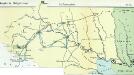
Nr. 6b. Kämpfe in Ostgalizien. Im Dnjestrgebiet
Galizien Weltkrieg <1914-1918>, Ostfront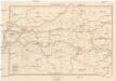
Galizien, Westlicher Theil
1 : 700000 Halič (Polsko a Ukrajina) Karl Fr. Pfau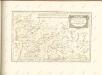

Übrige Länder der ehemaligen Österreich-Ung. Monarchie
1 : 900000 Halič (Polsko a Ukrajina) Koch, Wilhelm Opitz, Carl Arnd
Augustissimo Romanor. Imperatori Iosepho I. Hungaria Regi Invictissimo Mappam Hanc Regni Hungariae
1 : 540000 Mollova mapová sbírka Müller, Johann Christoph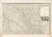
Mappa generalis regni Hungariae partiumque adnexarum Croatiae, Slavoniae...
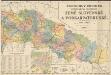
Podrobný přehled politického rozdělení země Slovenské a Podkarpatoruské
Vojenský zeměpisný ústav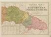
Podrobný přehled politického rozdělení Slovenska a Podkarpatské Rusi
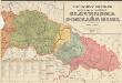
Podrobný přehled politického rozdělení Slovenska a Podkarp. Rusi
Vojenský zeměpisný ústav