Maps of Libeň

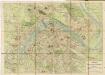
Plan des südlichen Moldauthal ́s bei Prag

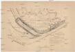
Plan der Gegend von Lieben bei Prag

Orientační plán hlavního města Prahy s okolím
1 : 5000
Výškopisný plán hlavního města Prahy s okolím

Lieben - c3990-1-004 - Kaiserpflichtexemplar der Landkarten des stabilen Katasters
1 : 2880
Lieben - c3990-1-003 - Kaiserpflichtexemplar der Landkarten des stabilen Katasters
1 : 2880
Lieben - c3990-1-001 - Kaiserpflichtexemplar der Landkarten des stabilen Katasters
1 : 2880
Lieben - c3990-1-002 - Kaiserpflichtexemplar der Landkarten des stabilen Katasters
1 : 2880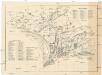
[Palmovka a Libeň]
Libeň (Praha, Česko) Vilím, Jan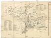
[Palmovka a Libeň]
Libeň (Praha, Česko) Vilím, Jan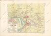
Plán VIII. části Prahy Libně a obcí sousedních
1 : 15000
Plan des Moldauthales zwischen Prag und Lieben
Auto-Praha : automobilní plán Velké Prahy a příručka pro automobilisty
1 : 50000
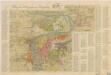
Orientační plán Prahy a obcí sousedních List 12.

Orientační plán král. Hl. města Prahy
[Praha-Holešovice]
Holešovice (Praha, Česko)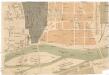
[Holešovice]
Holešovice (Praha, Česko) Srp, Jan Trávníček, František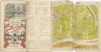
Wltžkův nejnovější orientační plán Prahy a nejbližšího okolí

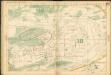
Plan der Gegend vor dem Porziczerthore zum Gebrauche bei der Beurtheilung der Distanzen
Bubeneč (Praha, Česko) Wacha, V.
Přehled tratí elektrických drah král. hlav. města Prahy
Plan von Prag und den Vororten
Pharusův plán král. hlav. města Prahy
1 : 11500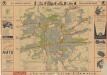
Praha

Plán Prahy a obcí sousedních
Praha (Česko) Hurtig, Alfred Neudörfl, Jaroslav Jos. R. Vilímek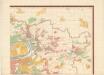
Orientierungsplan der Hauptstadt Prag
Jiřík, Rudolf
Plán hlavního města Prahy : [barevný plán hlavního města republiky Československé] : [se seznamem veřejných budov, ulic, náměstí, ostrovů, sadů a j. v Praze a v předměstích]
1 : 12000
Nejnovější a nejúplnější plán královského hlavního města Prahy a obcí sousedních

Plán tratí elektr. drah král. hl. města Prahy
Praha (Česko)
Nejnovější a nejúplnější plán královského hlav. města Prahy a obcí sousedních : s úplným seznamem ulic, náměstí atd.
1 : 12000


