Maps of Holešovice
[Praha-Holešovice]
Holešovice (Praha, Česko)
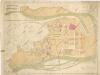
Polohopisný plán Bubenče, Holešovic - Buben, pak částí Dejvic a Libně
[Holešovice]
Holešovice (Praha, Česko) Srp, Jan Trávníček, František
Holeschowitz - c1960-1-001 - Kaiserpflichtexemplar der Landkarten des stabilen Katasters
1 : 2880
Holeschowitz - c1960-1-005 - Kaiserpflichtexemplar der Landkarten des stabilen Katasters
1 : 2880
Holeschowitz - c1960-1-003 - Kaiserpflichtexemplar der Landkarten des stabilen Katasters
1 : 2880
Holeschowitz - c1960-1-004 - Kaiserpflichtexemplar der Landkarten des stabilen Katasters
1 : 2880
Holeschowitz - c1960-1-006 - Kaiserpflichtexemplar der Landkarten des stabilen Katasters
1 : 2880
Holeschowitz - c1960-1-002 - Kaiserpflichtexemplar der Landkarten des stabilen Katasters
1 : 2880
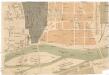
Polohopisný plán VII. části Prahy
Polohopisný plán VII. části Prahy

Polohopisný plán VII. části Prahy
1 : 4000
Polohopisný plán VII. části Prahy
1 : 4000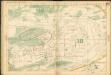
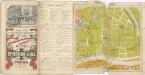
Auto-Praha : automobilní plán Velké Prahy a příručka pro automobilisty
1 : 50000
Výškopisný plán hlavního města Prahy s okolím
Wltžkův nejnovější orientační plán Prahy a nejbližšího okolí

Orientační plán hlavního města Prahy s okolím
1 : 5000
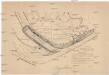
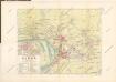
Plan der Gegend von Lieben bei Prag

Plan des südlichen Moldauthal ́s bei Prag

Lieben - c3990-1-004 - Kaiserpflichtexemplar der Landkarten des stabilen Katasters
1 : 2880
Lieben - c3990-1-003 - Kaiserpflichtexemplar der Landkarten des stabilen Katasters
1 : 2880
Lieben - c3990-1-001 - Kaiserpflichtexemplar der Landkarten des stabilen Katasters
1 : 2880
Lieben - c3990-1-002 - Kaiserpflichtexemplar der Landkarten des stabilen Katasters
1 : 2880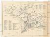
[Palmovka a Libeň]
Libeň (Praha, Česko) Vilím, Jan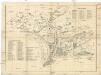
[Palmovka a Libeň]
Libeň (Praha, Česko) Vilím, Jan
Plan des Moldauthales zwischen Prag und Lieben
Plán VIII. části Prahy Libně a obcí sousedních
1 : 15000
[Karte von Prag]
1 : 14400 Praha (Česko : oblast)
Praha : plán kulturních památek
1 : 10000
![[Praha-Holešovice]](https://images-2.georeferencer.com/images/iiif/134547657856/full/,300/0/native.jpg)

