Maps of Holešovice
[Holešovice]
Holešovice (Praha, Česko) Srp, Jan Trávníček, František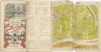
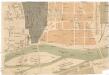
Wltžkův nejnovější orientační plán Prahy a nejbližšího okolí
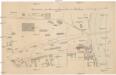
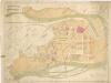
Situation des Eisenwalzwerkes in Bubna
Bubny (Praha, Česko) Brož, Josef Grefnetter, Josef Farský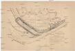
[Praha-Holešovice]
Holešovice (Praha, Česko)
Polohopisný plán Bubenče, Holešovic - Buben, pak částí Dejvic a Libně

[Pražské výstaviště]
Holešovice (Praha, Česko)
Holeschowitz - c1960-1-001 - Kaiserpflichtexemplar der Landkarten des stabilen Katasters
1 : 2880
Holeschowitz - c1960-1-005 - Kaiserpflichtexemplar der Landkarten des stabilen Katasters
1 : 2880
Holeschowitz - c1960-1-003 - Kaiserpflichtexemplar der Landkarten des stabilen Katasters
1 : 2880
Holeschowitz - c1960-1-004 - Kaiserpflichtexemplar der Landkarten des stabilen Katasters
1 : 2880
Holeschowitz - c1960-1-006 - Kaiserpflichtexemplar der Landkarten des stabilen Katasters
1 : 2880
Holeschowitz - c1960-1-002 - Kaiserpflichtexemplar der Landkarten des stabilen Katasters
1 : 2880
Polohopisný plán VII. části Prahy
Polohopisný plán VII. části Prahy

Polohopisný plán VII. části Prahy
1 : 4000
Polohopisný plán VII. části Prahy
1 : 4000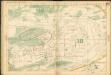
Auto-Praha : automobilní plán Velké Prahy a příručka pro automobilisty
1 : 50000
Plan des Moldauthales zwischen Prag und Lieben

[Praha-Staré Město]
Staré Město (Praha, Česko) Hlávka, Emil Libra, František Albert
Orientační plán hlavního města Prahy s okolím

Orientační plán hlavního města Prahy s okolím
1 : 5000
Orientační plán hlavního města Prahy s okolím

Výškopisný plán hlavního města Prahy s okolím

Orientační plán Prahy a obcí sousedních List 12.

Orientační plán král. Hl. města Prahy

Karolinenthal - c3051-1-002 - Kaiserpflichtexemplar der Landkarten des stabilen Katasters
1 : 2880
Karolinenthal - c3051-1-001 - Kaiserpflichtexemplar der Landkarten des stabilen Katasters
1 : 2880
Orientační plán hlavního města Prahy s okolím
1 : 5000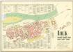
Karlín

![[Holešovice]](https://images-2.georeferencer.com/images/iiif/014512188018/full/,300/0/native.jpg)

