Maps of Holešovice

[Praha-Staré Město]
Staré Město (Praha, Česko) Hlávka, Emil Libra, František Albert
Neynowěgšj plán Prahy a wůkolj
Praha (Česko) Kamernik, Josef
... neu aufenommener und einzig richtiger Plan der Hauptstadt Prag in Böhmen
1 : 7300 Praha (Česko) Schubert, Anton Haas, František
Holeschowitz - c1960-1-001 - Kaiserpflichtexemplar der Landkarten des stabilen Katasters
1 : 2880
Holeschowitz - c1960-1-005 - Kaiserpflichtexemplar der Landkarten des stabilen Katasters
1 : 2880
Holeschowitz - c1960-1-003 - Kaiserpflichtexemplar der Landkarten des stabilen Katasters
1 : 2880
Holeschowitz - c1960-1-004 - Kaiserpflichtexemplar der Landkarten des stabilen Katasters
1 : 2880
Holeschowitz - c1960-1-006 - Kaiserpflichtexemplar der Landkarten des stabilen Katasters
1 : 2880
Holeschowitz - c1960-1-002 - Kaiserpflichtexemplar der Landkarten des stabilen Katasters
1 : 2880
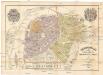
Polohopisný plán Karlína, Žižkova s Olšany
1 : 4000
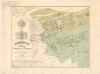
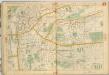
Polohopisný plán VII. části Prahy
1 : 4000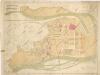
Polohopisný plán VII. části Prahy
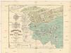
Polohopisný plán Karlína, Žižkova s Olšany
Karlín (Praha, Česko) Hurtig, Alfred Zap, Karel Vladislav F. Kytka
Polohopisný plán VII. části Prahy
Polohopisný plán Karlína, Žižkova s Olšany
Polohopisný plán Karlína, Žižkova s Olšany

Polohopisný plán VII. části Prahy
1 : 4000
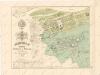
Orientační plán Prahy a obcí sousedních List 11.

Orientační plán Prahy a obcí sousedních List 11.
1 : 5000
Orientační plán hlavního města Prahy s okolím
1 : 5000
[Plán centra Prahy]
Praha (Česko)
[Praha-Staré Město]
Praha (Česko) Vasquez Pinos, Karl Rauh, Johann
Polohopisný plán na rozšíření kr. hl. města Prahy po zrušení hradeb od brány poříčské až k slepé
Praha (Česko) Hurtig, Alfred Mikolášek, Antonín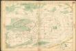
Auto-Praha : automobilní plán Velké Prahy a příručka pro automobilisty
1 : 50000
Eigentlicher Grundriß der Königlichen Statt Prag
Praha (Česko)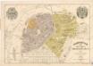
Polohopisný plán Starého města (I.), Dolejšího Nového města (II.), Josefova (V.)
Polohopisný plán Starého města (I.), Dolejšího Nového města (II.), Josefova (V.)
Staré Město (Praha, Česko) Hurtig, Alfred Weiss, Fr. F. Kytka
Staré Město / Nové Město
Auto-Praha : automobilní plán Velké Prahy a příručka pro automobilisty
1 : 50000
![[Praha-Staré Město]](https://images-3.georeferencer.com/images/iiif/150114200635/full/,300/0/native.jpg)

