Maps of Hammersmith and Fulham
London VI.SE - OS Six-Inch Map
1 : 10560 Topographic maps Ordnance Survey Ordnance Survey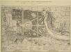
A Plan of the Palace Gardens and TOWN of KENSINGTON
1 : 4800 The title of this plan of Kensington Palace and gardens appears in English and French, with scale bars and a key to architectural and natural features, in a panel below the plan. Kensington Gardens were originally attached to Nottingham House, which was bought in 1689 by William III and turned into Kensington Palace. Queen Mary took a great interest in the gardens and had them landscaped by royal gardeners in formal Dutch patterns. Uprooted by order of Queen Anne at the beginning of the 18th century, the Dutch gardens were replaced in 1726 by this Wise and Bridgeman design, including the round pond, the Broad Walk and the Temple Lodge. Rocque, John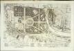
A plan of the palace gardens and town of Kensington
1 Plan : Kupferdruck ; 28 x 48 cm Rocque; Deharme John Rocque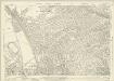
London (1915- Numbered sheets) IV.11 (includes: Hammersmith; Kensington) - 25 Inch Map
1 : 2500 Topographic maps Ordnance Survey Ordnance Survey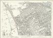
London (Edition of 1894-96) LIX (includes: Hammersmith; Kensington) - 25 Inch Map
1 : 2500 Topographic maps Ordnance Survey Ordnance Survey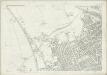
London (First Editions c1850s) XXXII (includes: Hammersmith; Kensington) - 25 Inch Map
1 : 2500 Topographic maps Ordnance Survey Ordnance Survey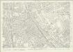
London (1915- Numbered sheets) IV.15 (includes: Fulham; Hammersmith; Kensington) - 25 Inch Map
1 : 2500 Topographic maps Ordnance Survey Ordnance Survey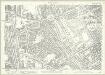
London (Edition of 1894-96) LXXIII (includes: Fulham; Hammersmith; Kensington) - 25 Inch Map
1 : 2500 Topographic maps Ordnance Survey Ordnance Survey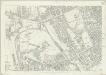
London (First Editions c1850s) XLI (includes: Fulham; Hammersmith; Kensington) - 25 Inch Map
1 : 2500 Topographic maps Ordnance Survey Ordnance Survey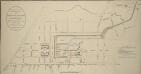
IMPROVED PLAN of the Termination of the GRAND JUNCTION CANAL at PADDINGTON With the Intended New Streets on the Estates of the Bishop of London
1 : 4800 The old course of the canal is indicated in blue.The improvements to the canal included: three new wharfs with enclosed reservoirs, at "A"; a service reservoir, at "B"; the enlargement of the canal by Arrow Road to allow barges to dock, at "C"; and a new basin for leisure boats, at "D". Also noted are three-and-a-half acres of land claimed by a Mr White, indicated by the letter "E".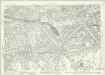
London (1915- Numbered sheets) IV.12 (includes: City Of Westminster; Paddington; St Marylebone) - 25 Inch Map
1 : 2500 Topographic maps Ordnance Survey Ordnance Survey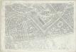
London (First Editions c1850s) XXXIII (includes: City Of Westminster; Paddington; St Marylebone) - 25 Inch Map
1 : 2500 Topographic maps Ordnance Survey Ordnance Survey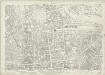
London (1915- Numbered sheets) IV.16 (includes: City Of Westminster; Kensington; Paddington) - 25 Inch Map
1 : 2500 Topographic maps Ordnance Survey Ordnance Survey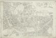
London (First Editions c1850s) XLII (includes: City Of Westminster; Kensington; Paddington) - 25 Inch Map
1 : 2500 Topographic maps Ordnance Survey Ordnance Survey
Plan Generale du Palais & Jardins de Kensington Situe dans la Conte de Middlesex a 2 miles de Londres tres Exactement Leve dessiene & Grave par Jean Rocque 1736
1 : 2400 On this plan of Kensington Palace and gardens, the key is at bottom left, with title and dedication at bottom centre, and scale bar at bottom left. The Kensington Gardens were originally attached to Nottingham House, which was bought in 1689 by William III and turned into Kensington Palace. Queen Mary took a great interest in the gardens and had them landscaped by royal gardeners in formal Dutch patterns. Uprooted by order of Queen Anne at the beginning of the 18th century, the Dutch gardens were replaced in 1726 by this Wise and Bridgeman design, which included the round pond, the Broad Walk and the Temple Lodge. Rocque, John
A Survey of Upton Farm in the Parish of Paddington in the County of Middlesex
1 : 2400 This is a 19th-century copy of Gardner's 1729 plan of Upton Farm.The title appears at top left, with compass rose at top right and scale bar at the foot of the sheet.The plan shows field boundaries, the dimensions of each field, names of tenants and describes different kinds of land use. Paddington remained a predominantly rural area until the end of the 18th century, when the Bishop of London granted the Grand Junction Canal Company permission to extend the canal from Brentford to Paddington. The Paddington Estate Act also allowed developers to start building on the estate. Gardner, William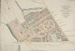
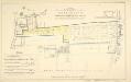
PADDINGTON Estate Design. Letting Ground on Building Leases opposite to HYDE PARK
1 : 2400 The development of Paddington began at the end of the Napoleonic wars, when the Bishop of London granted permission for building on his estate north of Hyde Park. Under Gutch's supervision, works continued into the 1850s, extending to Bayswater and the Edgware and Harrow Roads.The plan shows the new letting ground on the Bishop of London's estate in pink without shading, along with the reservoirs of the Grand Junction Canal Company and the ground plot of the Great Western Railway terminus.The title of this plan appears at top right, with compass rose at top left and scale bar at the foot of the plate. Gutch, George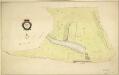
HYDE PARK
1 : 3960 The title and compass star of this plan appear at middle left, with them scale bar at bottom right. At over 340 acres the largest of all the royal parks, Hyde Park was originally a hunting ground for deer, boars and wild bull. Bequeathed to the monks of Westminster after the conquest of Geoffrey de Mandeville in the 1140s, the park was appropriated by Henry VIII at the dissolution of the monasteries in 1536. The park was opened to the public at the beginning of the 17th century, and remained a deer hunting ground until 1768. Bennett, S.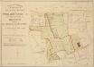
Plan of Estates IN THE PARISHES OF KENSINGTON AND ST MARGARET'S WESTMINSTER IN THE COUNTY OF MIDDLESEX Purchased by HER MAJESTY'S COMMISSIONERS for the EXHIBITION OF 1851.
1 : 4800 The site in South Kensington depicted in green on this plan was purchased by the Queen's Commissioners to host the Great Exhibition of 1851. The title, key to colours, compass star and scale bar appear down the left side of the plate. The boundaries of the four properties comprising the commissioners' estate are outlined as follows: Gore House in blue, Villar in red, Harrington in yellow and the Smith's Charity Estate in brown. Day & Son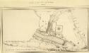
MILITARY SKETCH OF HYDE PARK
This plan shows the barracks along Knightsbridge erected for the Horse Guard at the end of the 18th century. The title appears at lower left, below the scale bar. At over 340 acres the largest of the royal parks, Hyde Park was originally a hunting ground for deer, boars and wild bull. Bequeathed to the monks of Westminster after the conquest of Geoffrey de Mandeville in the 1140s, the park was appropriated by Henry VIII at the dissolution of the monasteries in 1536. The park was opened to e public at the beginning of the 17th century and remained a deer-hunting ground until 1768. Baker, B.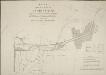
PLAN of the LANDS at PADDINGTON Proposed to be Leased and Exchanged by the Bishop of London and his Lessees AND THE Grand JUNCTION CANAL Company.
1 : 3168 Paddington was a predominantly rural area until the end of the 18th century.The Bishop of London granted the Grand Junction Canal Company permission to extend the canal from Brentford to Paddington.The Paddington Estate Act also allowed developers to start building on the estate.The title of this plan appears at top left. A reference table at bottom right gives a key to hatching and the dimensions of lots that formed part of the lease and exchange between the bishop and the canal company. Cary, J.
PLAN OF HYDE PARK as it was in 1725
1 : 792 This retrospective plan of Hyde Park was produced from an earlier plan held in the Vestry Room in St George's Church, Hanover Square. Its title features at top right, with the scale bar at top left. At over 340 acres of land the largest of all the royal parks, Hyde Park was originally a hunting ground for deer, boars and wild bull. Bequeathed to the monks of Westminster after the conquest of Geoffrey de Mandeville in the 1140s, the park was appropriated by Henry VIII at the dissolution of the monasteries in 1536. The park was opened to the public at the beginning of the 17th century, and remained a deer hunting ground until 1768. Neele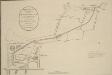
ORIGINAL PLAN of the Termination of the GRAND JUNCTION CANAL at PADDINGTON as Agreed with the Bishop of London and Confirmed by Act of Parliament to the Company
The land belonging to the Bishop of London is outlined in red, while another the property of another landowner, Mr Crompton, is outlined in yellow. Anonymous
Japan-British Exhibition 1910 ... at the "Great White City," Shepherd’s Bush, London
PLAN of the Several PLOTS OF GROUND for Building on at KENSINGTON
1 : 2136 This is a plan of plots of land for sale on the site of the Kitchen Garden in Kensington Gardens. The plan's title features at top centre, with compass star at top left and scale bar at bottom centre. The boundaries of the area for sale are outlined in blue, with the properties for which lease is not yet granted in yellow. Each property is numbered for reference, with key and terms of leases at bottom left. Standidge & Co.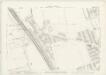
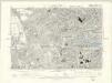
London VI.56 - OS London Town Plan
1 : 1056 Topographic maps Ordnance Survey Ordnance Survey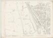
London VI.66 - OS London Town Plan
1 : 1056 Topographic maps Ordnance Survey Ordnance Survey
London VI.76 - OS London Town Plan
1 : 1056 Topographic maps Ordnance Survey Ordnance Survey
London VI.86 - OS London Town Plan
1 : 1056 Topographic maps Ordnance Survey Ordnance Survey