Maps of Kensington and Chelsea
A plan of the palace gardens and town of Kensington
1 Plan : Kupferdruck ; 28 x 48 cm Rocque; Deharme John Rocque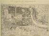
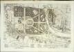
A Plan of the Palace Gardens and TOWN of KENSINGTON
1 : 4800 The title of this plan of Kensington Palace and gardens appears in English and French, with scale bars and a key to architectural and natural features, in a panel below the plan. Kensington Gardens were originally attached to Nottingham House, which was bought in 1689 by William III and turned into Kensington Palace. Queen Mary took a great interest in the gardens and had them landscaped by royal gardeners in formal Dutch patterns. Uprooted by order of Queen Anne at the beginning of the 18th century, the Dutch gardens were replaced in 1726 by this Wise and Bridgeman design, including the round pond, the Broad Walk and the Temple Lodge. Rocque, John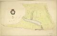
HYDE PARK
1 : 3960 The title and compass star of this plan appear at middle left, with them scale bar at bottom right. At over 340 acres the largest of all the royal parks, Hyde Park was originally a hunting ground for deer, boars and wild bull. Bequeathed to the monks of Westminster after the conquest of Geoffrey de Mandeville in the 1140s, the park was appropriated by Henry VIII at the dissolution of the monasteries in 1536. The park was opened to the public at the beginning of the 17th century, and remained a deer hunting ground until 1768. Bennett, S.
Plan Generale du Palais & Jardins de Kensington Situe dans la Conte de Middlesex a 2 miles de Londres tres Exactement Leve dessiene & Grave par Jean Rocque 1736
1 : 2400 On this plan of Kensington Palace and gardens, the key is at bottom left, with title and dedication at bottom centre, and scale bar at bottom left. The Kensington Gardens were originally attached to Nottingham House, which was bought in 1689 by William III and turned into Kensington Palace. Queen Mary took a great interest in the gardens and had them landscaped by royal gardeners in formal Dutch patterns. Uprooted by order of Queen Anne at the beginning of the 18th century, the Dutch gardens were replaced in 1726 by this Wise and Bridgeman design, which included the round pond, the Broad Walk and the Temple Lodge. Rocque, John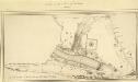
MILITARY SKETCH OF HYDE PARK
This plan shows the barracks along Knightsbridge erected for the Horse Guard at the end of the 18th century. The title appears at lower left, below the scale bar. At over 340 acres the largest of the royal parks, Hyde Park was originally a hunting ground for deer, boars and wild bull. Bequeathed to the monks of Westminster after the conquest of Geoffrey de Mandeville in the 1140s, the park was appropriated by Henry VIII at the dissolution of the monasteries in 1536. The park was opened to e public at the beginning of the 17th century and remained a deer-hunting ground until 1768. Baker, B.
PLAN OF HYDE PARK as it was in 1725
1 : 792 This retrospective plan of Hyde Park was produced from an earlier plan held in the Vestry Room in St George's Church, Hanover Square. Its title features at top right, with the scale bar at top left. At over 340 acres of land the largest of all the royal parks, Hyde Park was originally a hunting ground for deer, boars and wild bull. Bequeathed to the monks of Westminster after the conquest of Geoffrey de Mandeville in the 1140s, the park was appropriated by Henry VIII at the dissolution of the monasteries in 1536. The park was opened to the public at the beginning of the 17th century, and remained a deer hunting ground until 1768. Neele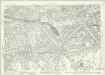
London (1915- Numbered sheets) IV.12 (includes: City Of Westminster; Paddington; St Marylebone) - 25 Inch Map
1 : 2500 Topographic maps Ordnance Survey Ordnance Survey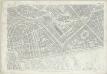
London (First Editions c1850s) XXXIII (includes: City Of Westminster; Paddington; St Marylebone) - 25 Inch Map
1 : 2500 Topographic maps Ordnance Survey Ordnance Survey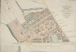
PADDINGTON Estate Design. Letting Ground on Building Leases opposite to HYDE PARK
1 : 2400 The development of Paddington began at the end of the Napoleonic wars, when the Bishop of London granted permission for building on his estate north of Hyde Park. Under Gutch's supervision, works continued into the 1850s, extending to Bayswater and the Edgware and Harrow Roads.The plan shows the new letting ground on the Bishop of London's estate in pink without shading, along with the reservoirs of the Grand Junction Canal Company and the ground plot of the Great Western Railway terminus.The title of this plan appears at top right, with compass rose at top left and scale bar at the foot of the plate. Gutch, George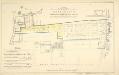
PLAN of the Several PLOTS OF GROUND for Building on at KENSINGTON
1 : 2136 This is a plan of plots of land for sale on the site of the Kitchen Garden in Kensington Gardens. The plan's title features at top centre, with compass star at top left and scale bar at bottom centre. The boundaries of the area for sale are outlined in blue, with the properties for which lease is not yet granted in yellow. Each property is numbered for reference, with key and terms of leases at bottom left. Standidge & Co.
A Survey of Upton Farm in the Parish of Paddington in the County of Middlesex
1 : 2400 This is a 19th-century copy of Gardner's 1729 plan of Upton Farm.The title appears at top left, with compass rose at top right and scale bar at the foot of the sheet.The plan shows field boundaries, the dimensions of each field, names of tenants and describes different kinds of land use. Paddington remained a predominantly rural area until the end of the 18th century, when the Bishop of London granted the Grand Junction Canal Company permission to extend the canal from Brentford to Paddington. The Paddington Estate Act also allowed developers to start building on the estate. Gardner, William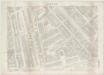
London VI.69 - OS London Town Plan
1 : 1056 Topographic maps Ordnance Survey Ordnance Survey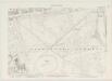
London VI.79 - OS London Town Plan
1 : 1056 Topographic maps Ordnance Survey Ordnance Survey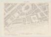
London VI.70 - OS London Town Plan
1 : 1056 Topographic maps Ordnance Survey Ordnance Survey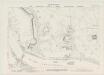
London VI.80 - OS London Town Plan
1 : 1056 Topographic maps Ordnance Survey Ordnance Survey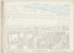
London VI.90 - OS London Town Plan
1 : 1056 Topographic maps Ordnance Survey Ordnance Survey
London VI.89 - OS London Town Plan
1 : 1056 Topographic maps Ordnance Survey Ordnance Survey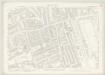
London VI.78 - OS London Town Plan
1 : 1056 Topographic maps Ordnance Survey Ordnance Survey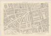
London VI.68 - OS London Town Plan
1 : 1056 Topographic maps Ordnance Survey Ordnance Survey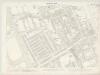
London VI.88 - OS London Town Plan
1 : 1056 Topographic maps Ordnance Survey Ordnance Survey
Knightsbridge showing the Halfway House
The Halfway House is depicted in plan and elevation on the north side of the road on the site of today's Prince of Wales Gate. This ancient inn, with its ramshackle stables and pigsties, had long been popular with highwaymen in the area. Salway, Joseph
Insurance Plan of London Western District Vol. A: sheet 17
1 : 480 This detailed 1901 plan of London is one of a series of forty-one sheets in an atlas originally produced to aid insurance companies in assessing fire risks. The building footprints, their use (commercial, residential, educational, etc.), the number of floors and the height of the building, as well as construction materials (and thus risk of burning) and special fire hazards (chemicals, kilns, ovens) were documented in order to estimate premiums. Names of individual businesses, property lines, and addresses were also often recorded. Together these maps provide a rich historical shapshot of the commercial activity and urban landscape of towns and cities at the time. The British Library holds a comprehensive collection of fire insurance plans produced by the London-based firm Charles E. Goad Ltd. dating back to 1885. These plans were made for most important towns and cities of the British Isles at the scales of 1:480 (1 inch to 40 feet), as well as many foreign towns at 1:600 (1 inch to 50 feet). Chas E Goad Limited Chas E Goad Limited
Insurance Plan of London West, North West Vol. B: sheet 7-2
1 : 480 This detailed 1892 plan of London is one of a series of eleven sheets in an atlas originally produced to aid insurance companies in assessing fire risks. The building footprints, their use (commercial, residential, educational, etc.), the number of floors and the height of the building, as well as construction materials (and thus risk of burning) and special fire hazards (chemicals, kilns, ovens) were documented in order to estimate premiums. Names of individual businesses, property lines, and addresses were also often recorded. Together these maps provide a rich historical shapshot of the commercial activity and urban landscape of towns and cities at the time. The British Library holds a comprehensive collection of fire insurance plans produced by the London-based firm Charles E. Goad Ltd. dating back to 1885. These plans were made for most important towns and cities of the British Isles at the scales of 1:480 (1 inch to 40 feet), as well as many foreign towns at 1:600 (1 inch to 50 feet). Chas E Goad Limited Chas E Goad Limited
Insurance Plan of London West North-West District Vol. B: sheet 21-1
1 : 480 This detailed 1902 plan of London is one of a series of eighteen sheets in an atlas originally produced to aid insurance companies in assessing fire risks. The building footprints, their use (commercial, residential, educational, etc.), the number of floors and the height of the building, as well as construction materials (and thus risk of burning) and special fire hazards (chemicals, kilns, ovens) were documented in order to estimate premiums. Names of individual businesses, property lines, and addresses were also often recorded. Together these maps provide a rich historical shapshot of the commercial activity and urban landscape of towns and cities at the time. The British Library holds a comprehensive collection of fire insurance plans produced by the London-based firm Charles E. Goad Ltd. dating back to 1885. These plans were made for most important towns and cities of the British Isles at the scales of 1:480 (1 inch to 40 feet), as well as many foreign towns at 1:600 (1 inch to 50 feet). Chas E Goad Limited Chas E Goad Limited
Insurance Plan of London West North-West District Vol. B: sheet 27-1
1 : 480 This detailed 1902 plan of London is one of a series of eighteen sheets in an atlas originally produced to aid insurance companies in assessing fire risks. The building footprints, their use (commercial, residential, educational, etc.), the number of floors and the height of the building, as well as construction materials (and thus risk of burning) and special fire hazards (chemicals, kilns, ovens) were documented in order to estimate premiums. Names of individual businesses, property lines, and addresses were also often recorded. Together these maps provide a rich historical shapshot of the commercial activity and urban landscape of towns and cities at the time. The British Library holds a comprehensive collection of fire insurance plans produced by the London-based firm Charles E. Goad Ltd. dating back to 1885. These plans were made for most important towns and cities of the British Isles at the scales of 1:480 (1 inch to 40 feet), as well as many foreign towns at 1:600 (1 inch to 50 feet). Chas E Goad Limited Chas E Goad Limited
Kensington Gore Sheet 7
Among the residents of Kensington Gore was the philanthropist and parliamentarian William Wilberforce, whose name is associated with the campaign for the abolition of the slave trade. Gore House, wherehe lived between 1808 and 1821, is depicted in plan form on the south side of Kensington Gore. Built in the 1750s, the house was decorated by the architect Robert Adams. It was the most easterly of a row of mansions built in the 18th century between Palace Gate and Knightsbridge. Salway, Joseph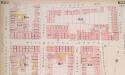
Insurance Plan of London West, North West Vol. B: sheet 22-1
1 : 480 This detailed 1892 plan of London is one of a series of eleven sheets in an atlas originally produced to aid insurance companies in assessing fire risks. The building footprints, their use (commercial, residential, educational, etc.), the number of floors and the height of the building, as well as construction materials (and thus risk of burning) and special fire hazards (chemicals, kilns, ovens) were documented in order to estimate premiums. Names of individual businesses, property lines, and addresses were also often recorded. Together these maps provide a rich historical shapshot of the commercial activity and urban landscape of towns and cities at the time. The British Library holds a comprehensive collection of fire insurance plans produced by the London-based firm Charles E. Goad Ltd. dating back to 1885. These plans were made for most important towns and cities of the British Isles at the scales of 1:480 (1 inch to 40 feet), as well as many foreign towns at 1:600 (1 inch to 50 feet). Chas E Goad Limited Chas E Goad Limited
Insurance Plan of London West, North West Vol. B: sheet 7-1
1 : 480 This detailed 1892 plan of London is one of a series of eleven sheets in an atlas originally produced to aid insurance companies in assessing fire risks. The building footprints, their use (commercial, residential, educational, etc.), the number of floors and the height of the building, as well as construction materials (and thus risk of burning) and special fire hazards (chemicals, kilns, ovens) were documented in order to estimate premiums. Names of individual businesses, property lines, and addresses were also often recorded. Together these maps provide a rich historical shapshot of the commercial activity and urban landscape of towns and cities at the time. The British Library holds a comprehensive collection of fire insurance plans produced by the London-based firm Charles E. Goad Ltd. dating back to 1885. These plans were made for most important towns and cities of the British Isles at the scales of 1:480 (1 inch to 40 feet), as well as many foreign towns at 1:600 (1 inch to 50 feet). Chas E Goad Limited Chas E Goad Limited
Knightsbridge, 1 Mile from Hyde Park Corner
Gray's Nursery and Seed Shopis depicted in plan form on the south side of this stretch of Knightsbridge, next to property belonging to James Vere. A milestone on the north side of the road indicates a distance ofone mile to Hyde Park Corner, where the toll road terminated. Salway, Joseph


