Maps of Upper Franconia

Cours de Postes dans la Franconie par Bamberg, Baireut etc. jusqu'à Eger
Mollova mapová sbírka Homann, Johann Baptist Homann, Johann Baptista - dědici
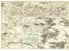
Das Bisthum Bamberg
1 Karte : Kupferdruck ; 21 x 25 cm Reilly F. J. J. von Reilly
Tabula Geographica Novissima Principalis Episcopatûs Bambergensis
1 : 260000 Mollova mapová sbírka Seutter, Matthäus Seutter, Matthäus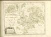

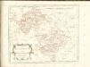
Des Bisthums Bamberg nördliche Aemter
1 Karte : Kupferdruck ; 19 x 29 cm Reilly F. J. J. von Reilly
Sac. Rom. Imperii principatus & episcopatus Bambergensis nova tabula geographica
1 : 215000 Bamberg-oblast (Německo) Homann, Johann Baptist á Io. Bapt. Homanno
Sac. Rom. Imperii principatus [et] episcopatus Bambergensis nova tabula geographica
1 Karte : Kupferdruck ; 47 x 56 cm Homann Johann Baptist Homann
Sac. Rom. Imperii principatus [et] episcopatus Bambergensis nova tabula geographica
1 Karte : Kupferdruck ; 47 x 56 cm Homann Johann Baptist Homann
Special=Charte der kön. baier. Provinz Bamberg
1 Karte auf 4 Blatt : Kupferdruck ; 73 x 72 cm Roppelt in der kön. baier. priv. Landkartenhandlung Ad: Gottl: Schneider u: Weigels
Sac. Rom. Imperii Principatus & Episcopatus Bambergensis Nova Tabula Geographica
1 : 260000 Mollova mapová sbírka Homann, Johann Baptist Homann, Johann Baptista

Tabulae principatus Brandenburgico-Culmbacensis sive Baruthini
1 : 225600 Bavorsko severní (Německo) Riediger, Johann Adam Lotter, Tobias Conrad I.A. Riediger
Tabulae Marchionatus Brandenburgico-Culmbacensis sive Baruthini Pars Superior cum adjacentibus Regionibus exhibita
1 : 180000 Mollova mapová sbírka Riediger, Johann Adam Seutter, Matthäus
Coburg
1 : 300000 R. Mittelbach
Bamberg 101, uit: Special-Karte von Mittel-Europa / nach amtlichen Quellen bearbeitet von W. Liebenow
1 : 300000 titelvariant: W. Liebenow's Mittel-Europa; Annotatie: Titel boven de bladen: W. Liebenow's Mittel-Europa Johannes Wilhelm Liebenow 1822-1897 Frankfurt a. M. : Ludwig Ravenstein
TERRA ADVOCATORVM | Vulgo | VOIGHTLAND
Descripta ab Olao Ioannis Gotho | S.R.M. Sueciæ Geographo. Amstelædami | J. Blaeu excudebat.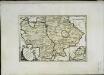
Des Bisthums Bamberg südliche Aemter
1 Karte : Kupferdruck ; 20 x 30 cm Reilly F. J. J. von Reilly
Sacri Romani imperii circuli et electoratus Bavariae tabula, 1
4 Blätter : s.n.
Herzogtum Sachsen-Coburg-Saalfeld 1820 Verwaltungsstruktur [mit] Fürstentum Lichtenberg
Sachsen-Coburg-Saalfeld Verwaltung Kunz, Andreas ; Moeschl, Joachim Robert
S.R.Imp. Circuli Franconici Geographica Delineatio Francken-Land mit Seinen Gräntzen
Mollova mapová sbírka Endter, Wolfgang Moritz Endter, Wolfgang Moritz
Terra Advocatorvm Vulgo Voightland
1 : 290000 Mollova mapová sbírka Örnehufvud, Olof Hansson Blaeu, Joan I.
Herzogtum Sachsen-Meiningen 1829 Verwaltungsstruktur
Sachsen-Meiningen Verwaltung Kunz, Andreas ; Moeschl, Joachim Robert
Zu den Operationen der Generale Syburg, Schenkendorf und Linden gegen die Reichsarmee, vom 15ten Februar bis zum 5ten April 1761

Terra Advocatorvm vulgo Voightland
1 : 290000 Vogtland (Německo) Örnehufvud, Olof Hansson Blaeu, Joan J. Blaeu
Karte des Thüringer-Wald-Gebirges zugleich special Karte des Herzogthums Sachs-Meiningen-Hildburghausen des Fürstenthums Coburg und der Schwarzburgischen Fürstenthümer Rudolstadt und Sondershausen
Grosser Hand-Atlas über alle Theile der Erde in 170 Karten Meyer, J. Verlag des Bibliographischen Instituts
Des Herzogthums Oberpfalz nördliche Pfleggerichte mit der gefürsteten Grafschaft Sternstein
1 Karte : Kupferdruck ; 18 x 27 cm Reilly F. J. J. von Reilly
Deutsche Strassenprofilkarte für Rad - und Autofahrer 58 Nürnberg