Maps of Upper Franconia

Cours de Postes dans la Franconie par Bamberg, Baireut etc. jusqu'à Eger
Mollova mapová sbírka Homann, Johann Baptist Homann, Johann Baptista - dědici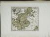
Das Bisthum Bamberg
1 Karte : Kupferdruck ; 21 x 25 cm Reilly F. J. J. von Reilly
Tabulae principatus Brandenburgico-Culmbacensis sive Baruthini
1 : 225600 Bavorsko severní (Německo) Riediger, Johann Adam Lotter, Tobias Conrad I.A. Riediger
Tabula Geographica Novissima Principalis Episcopatûs Bambergensis
1 : 260000 Mollova mapová sbírka Seutter, Matthäus Seutter, Matthäus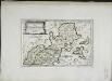
Des Bisthums Bamberg nördliche Aemter
1 Karte : Kupferdruck ; 19 x 29 cm Reilly F. J. J. von Reilly
Bamberg 101, uit: Special-Karte von Mittel-Europa / nach amtlichen Quellen bearbeitet von W. Liebenow
1 : 300000 titelvariant: W. Liebenow's Mittel-Europa; Annotatie: Titel boven de bladen: W. Liebenow's Mittel-Europa Johannes Wilhelm Liebenow 1822-1897 Frankfurt a. M. : Ludwig Ravenstein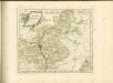

Sac. Rom. Imperii principatus & episcopatus Bambergensis nova tabula geographica
1 : 215000 Bamberg-oblast (Německo) Homann, Johann Baptist á Io. Bapt. Homanno
Tabulae Marchionatus Brandenburgico-Culmbacensis sive Baruthini Pars Superior cum adjacentibus Regionibus exhibita
1 : 180000 Mollova mapová sbírka Riediger, Johann Adam Seutter, Matthäus
Sac. Rom. Imperii Principatus & Episcopatus Bambergensis Nova Tabula Geographica
1 : 260000 Mollova mapová sbírka Homann, Johann Baptist Homann, Johann Baptista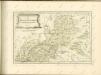

142. Plauen (bijgeschreven: Löbenstein), uit: Topographische Uebersichtskarte des Deutschen Reiches / herausgegeben v. d. Kartogr. Abt. d. Königl. Preuß. Landesaufnahme
1 : 200000 titelvariant: Topogr. Übersichtskarte des Deutschen Reiches; Annotatie: Titel boven bladen ook: Topogr. Übersichtskarte des Deutschen Reiches; Annotatie geografische gegevens: Op elk blad twee maatstokken: 10 Kilometer = 5,5 cm; 1 geogr. Meile = 3,6 cm; Legenda onder op elk blad Königlich Preußische Landesaufnahme. Kartographische Abtheilung [S.l : Königlich Preußische Landesaufnahme, Kartographische Abtheilung]
Coburg
1 : 300000 R. Mittelbach
154. Bayreuth, uit: Topographische Uebersichtskarte des Deutschen Reiches / herausgegeben v. d. Kartogr. Abt. d. Königl. Preuß. Landesaufnahme
1 : 200000 titelvariant: Topogr. Übersichtskarte des Deutschen Reiches; Annotatie: Titel boven bladen ook: Topogr. Übersichtskarte des Deutschen Reiches; Annotatie geografische gegevens: Op elk blad twee maatstokken: 10 Kilometer = 5,5 cm; 1 geogr. Meile = 3,6 cm; Legenda onder op elk blad Königlich Preußische Landesaufnahme. Kartographische Abtheilung [S.l : Königlich Preußische Landesaufnahme, Kartographische Abtheilung]
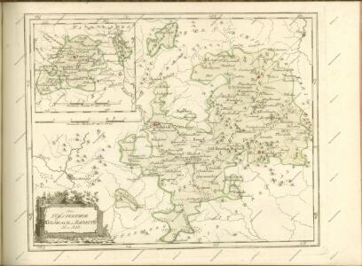
Herzogtum Sachsen-Coburg-Saalfeld 1820 Verwaltungsstruktur [mit] Fürstentum Lichtenberg
Sachsen-Coburg-Saalfeld Verwaltung Kunz, Andreas ; Moeschl, Joachim Robert
Aš
1 : 75000 Aš (Česko : oblast) Vojenský zeměpisný ústav
Aš
1 : 75000 Aš-oblast (Česko) Vojenský zeměpisný ústav
Geographica Descriptio Montani cujusdam Districtus in Franconia in quo Illustrissimorum S. R. I. Comitum à Giech Particulare Territorium
1 : 65000 Mollova mapová sbírka Homann, Johann Baptist Homann, Johann Baptista
Übersichtskarte der Polizeibezirke Culmbach, Stadtsteinach und Weismain im Jahre 1855
1 : 106000 Kirmaier [...] grav. [S.l.] : [s.n.]

Rossbach in Bohmen und Oelsnitz (Im Sachsen).
from Spezialkarte der osterreichisch-ungarischen Monarchie.
III. vojenské mapování 3948
1 : 75000
III. vojenské mapování 3848
1 : 75000
Asch.
from Spezialkarte der osterreichisch-ungarischen Monarchie.
Asch
1 : 75000 Aš (Česko : oblast) Ansion K. u. k. Militärgeographisches Institut
Asch
1 : 75000 Aš (Česko : oblast) K. u. k. Militärgeographisches Institut
III. vojenské mapování 3948
1 : 75000