Maps of Upper Franconia

Sac. Rom. Imperii principatus [et] episcopatus Bambergensis nova tabula geographica
1 Karte : Kupferdruck ; 47 x 56 cm Homann Johann Baptist Homann
Sac. Rom. Imperii principatus [et] episcopatus Bambergensis nova tabula geographica
1 Karte : Kupferdruck ; 47 x 56 cm Homann Johann Baptist Homann
Sac. Rom. Imperii principatus & episcopatus Bambergensis nova tabula geographica
1 : 215000 Bamberg-oblast (Německo) Homann, Johann Baptist á Io. Bapt. Homanno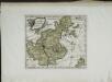
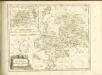
Das Bisthum Bamberg
1 Karte : Kupferdruck ; 21 x 25 cm Reilly F. J. J. von Reilly
Tabula Geographica Novissima Principalis Episcopatûs Bambergensis
1 : 260000 Mollova mapová sbírka Seutter, Matthäus Seutter, Matthäus
Special=Charte der kön. baier. Provinz Bamberg
1 Karte auf 4 Blatt : Kupferdruck ; 73 x 72 cm Roppelt in der kön. baier. priv. Landkartenhandlung Ad: Gottl: Schneider u: Weigels
Sac. Rom. Imperii Principatus & Episcopatus Bambergensis Nova Tabula Geographica
1 : 260000 Mollova mapová sbírka Homann, Johann Baptist Homann, Johann Baptista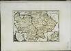
Des Bisthums Bamberg südliche Aemter
1 Karte : Kupferdruck ; 20 x 30 cm Reilly F. J. J. von Reilly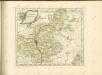

Cours de Postes dans la Franconie par Bamberg, Baireut etc. jusqu'à Eger
Mollova mapová sbírka Homann, Johann Baptist Homann, Johann Baptista - dědici
Sacri Romani imperii circuli et electoratus Bavariae tabula, 1
4 Blätter : s.n.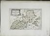
Des Bisthums Bamberg nördliche Aemter
1 Karte : Kupferdruck ; 19 x 29 cm Reilly F. J. J. von Reilly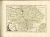

Bamberg 101, uit: Special-Karte von Mittel-Europa / nach amtlichen Quellen bearbeitet von W. Liebenow
1 : 300000 titelvariant: W. Liebenow's Mittel-Europa; Annotatie: Titel boven de bladen: W. Liebenow's Mittel-Europa Johannes Wilhelm Liebenow 1822-1897 Frankfurt a. M. : Ludwig Ravenstein
Deutsche Strassenprofilkarte für Rad - und Autofahrer 58 Nürnberg

153. Bamberg, uit: Topographische Uebersichtskarte des Deutschen Reiches / herausgegeben v. d. Kartogr. Abt. d. Königl. Preuß. Landesaufnahme
1 : 200000 titelvariant: Topogr. Übersichtskarte des Deutschen Reiches; Annotatie: Titel boven bladen ook: Topogr. Übersichtskarte des Deutschen Reiches; Annotatie geografische gegevens: Op elk blad twee maatstokken: 10 Kilometer = 5,5 cm; 1 geogr. Meile = 3,6 cm; Legenda onder op elk blad Königlich Preußische Landesaufnahme. Kartographische Abtheilung [S.l : Königlich Preußische Landesaufnahme, Kartographische Abtheilung]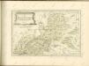

Charte von dem Grosgerzogthum Würzburg, nebst dem Fürstenthum Schwarzenberg, den Grafschafften Castell und Limpurg-Speckfeld, der Herrschafft Wiesentheid &c
1 : 188000 Bavorsko (Německo) Hammer, C. F. bey Homanns Erben
Tabulae geographicae principatus Brandenburg. Culmb. sive Baruthini
1 : 179600 Bavorsko severní (Německo) Lotter, Tobias Conrad Tob. Conrad Lotter
Tabulae principatus Brandenburgico-Culmbacensis sive Baruthini
1 : 225600 Bavorsko severní (Německo) Riediger, Johann Adam Lotter, Tobias Conrad I.A. Riediger
Tabulae Marchionatus Brandenburgico-Culmbacensis sive Baruthini Pars Superior cum adjacentibus Regionibus exhibita
1 : 180000 Mollova mapová sbírka Riediger, Johann Adam Seutter, Matthäus
Das Franken-Weinland
1 : 505000 Bavorsko (Německo) Hellrung, Carl Ludwig Baensch, E. Rubach'schen Buchhandlung
Coburg
1 : 300000 R. Mittelbach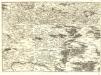
S.R.Imp. Circuli Franconici Geographica Delineatio Francken-Land mit Seinen Gräntzen
Mollova mapová sbírka Endter, Wolfgang Moritz Endter, Wolfgang Moritz
Nürnberg 115, uit: Special-Karte von Mittel-Europa / nach amtlichen Quellen bearbeitet von W. Liebenow
1 : 300000 titelvariant: W. Liebenow's Mittel-Europa; Annotatie: Titel boven de bladen: W. Liebenow's Mittel-Europa Johannes Wilhelm Liebenow 1822-1897 Frankfurt a. M. : Ludwig Ravenstein
141. Coburg, uit: Topographische Uebersichtskarte des Deutschen Reiches / herausgegeben v. d. Kartogr. Abt. d. Königl. Preuß. Landesaufnahme
1 : 200000 titelvariant: Topogr. Übersichtskarte des Deutschen Reiches; Annotatie: Titel boven bladen ook: Topogr. Übersichtskarte des Deutschen Reiches; Annotatie geografische gegevens: Op elk blad twee maatstokken: 10 Kilometer = 5,5 cm; 1 geogr. Meile = 3,6 cm; Legenda onder op elk blad Königlich Preußische Landesaufnahme. Kartographische Abtheilung [S.l : Königlich Preußische Landesaufnahme, Kartographische Abtheilung]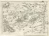
Geographica Provinciarum Sveviae Descriptio =
Mollova mapová sbírka Hurter, Johann Christoph Bodenehr, Johann Georg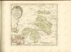

![Sac. Rom. Imperii principatus [et] episcopatus Bambergensis nova tabula geographica](http://biblio.unibe.ch/web-apps/maps/zoomify.php?pic=Ryh_4903_5.jpg&col=ryh)

