Maps of Region Rhein-Neckar

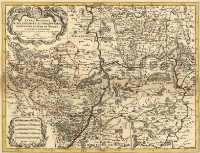
Partie Orientale du Palatinat et Eslectorat du Rhein. Les Eveschés de Spire, de Wormes et le Comté de Linange
1 : 260000 Mollova mapová sbírka Sanson, Guillaume Jaillot, Alexis Hubert
Partie Orientale du Palatinat et Eslectorat du Rhein. Les Eveschés de Spire, de Wormes et le Comté de Linange
1 : 260000 Mollova mapová sbírka Sanson, Guillaume Jaillot, Alexis Hubert
Partie Orientale Du Palatinat et Eslectoriat Du Rhein. Les Eveschés De Spire, De Wormes et Le Comté De Linange. [Karte], in: Atlas nouveau, contenant toutes les parties du monde [...], Bd. 1, S. 184.
1 Karte aus Atlas Sanson, Nicolas Jaillot, Alexis Hubert und Mortier, Pieter
Carte topographique d'Allemagne
1 : 214500 Bádensko (Německo) Facius, Johann Gottlieb chez I.W.A. Iaeger
Carte topographique d'Allemagne
1 : 214500 Bádensko (Německo) Jaeger, Johann Wilhelm Abraham I. et K.
Per Inclyti Circuli Suevici Supremorum Ordinum :
1 : 160000 Mollova mapová sbírka Pfeffel, Johann Andreas Homann, Johann Baptista - dědici
Per Inclyti Circuli Suevici Supremorum Ordinum :
1 : 160000 Mollova mapová sbírka Pfeffel, Johann Andreas Pfeffel, Johann Andreas I.
Le Theatre de Bellone :
Mollova mapová sbírka Schenk, Pieter Braakman, Adriaan
Generalkarte von Zentraleuropa

Mannheim 113, uit: Special-Karte von Mittel-Europa / nach amtlichen Quellen bearbeitet von W. Liebenow
1 : 300000 titelvariant: W. Liebenow's Mittel-Europa; Annotatie: Titel boven de bladen: W. Liebenow's Mittel-Europa Johannes Wilhelm Liebenow 1822-1897 Frankfurt a. M. : Ludwig Ravenstein

Mannheim 113, uit: [W. Liebenow's Special-Karte von Mittel-Europa]
1 : 300000 titelvariant: W. Liebenow's Mittel-Europa; Annotatie: Titel boven de bladen: W. Liebenow's Mittel-Europa Johannes Wilhelm Liebenow 1822-1897 Hannover : Hermann Oppermann
Geognostische Reise-Karte der Umgegend von Heidelberg
1 : 250000 Groos
Militair Karte von Süd-Deutschland in 20 Sectionen
1 : 400000 5. Section Coulon, Alois von A. von Coulon
Carte Tres exacte du Theatre de la Guerre Sur le Rhein
Mollova mapová sbírka Briffaut, Etienne Briffaut, Etienne
Die Pfalz oder Rhein - Bayern

Cursus Rheni infra Argentoratum usq; ad Wormatiam, cum adjacentibus Regionibus
1 : 2900000 Mollova mapová sbírka Seutter, Matthäus Seutter, Matthäus

Carte Particuliere Des Pays Qui Sont Situéz Entre Le Rhein, La Saare, la Moselle, Et La Basse Alsace [...] [Karte], in: Atlas nouveau, contenant toutes les parties du monde [...], Bd. 1, S. 244.
1 Karte aus Atlas Sanson, Nicolas Jaillot, Alexis Hubert und Mortier, Pieter
Carte particulìere des pays quì sont sítuéz entre la Rhein, la Saare, la Mosselle et la basse Alsace, contenant partìe du Palatinat, des Electorats de Mayence de Treves des Eveschés de Spìres et de Wormes avec les Duchés de Deuxponts et des Sìmmeren.
from Atlas françois : contenant les cartes geographiques dans lesquelles sont tres exactement remarquez les empires, monarchies, royaumes et estats de l'Europe, de l'Asie, de l'Afrique et l'Amérique : avec les tables et cartes particulieres de France, de Flandre, d'Allemagne, d'Espagne et d'Italie / par ... Hubert Iaillot, geographe ordinaire ...
Provinz Starkenburg und Rheinhessen
1 : 250000 Hügel, Adolf Diehl
Generalkarte von Württemberg: Blatt I
1 : 1500000 Mit Übersichtskarte. Terrainzeichnung: Bach, Topograf und Hauptmann Lithografie: Rebmann und Sommer Herausgeber: K. statistisch-topografisches Büro
Circuli Franconicae pars occidentalis, exhibens simul integrum fere electoratum Moguntinum
1 : 860000 Hesensko (Německo) Homann, Johann Baptist Schönborn, Lothar Franz von J. B. Homann
Circuli Franconicae pars occidentalis, exhibens simul integrum fere electoratum Moguntinum
1 : 860000 Hesensko (Německo) Homann, Johann Baptist Lothario, Francisco J. B. Homann
Suevia universa IX. tabulis delineata, 1
1 Blatt : s.n.
Provinz Starkenburg und Rheinhessen
1 : 250000 Hügel, Adolf Diehl
Suevia Universa
1 : 170000 Mollova mapová sbírka Michal, Jacques de Seutter, Matthäus Seutter, Matthäus
Section Worms, uit: Charte von dem Grossherzogtum Hessen und dem Herzogtum Nassau / trigonometrisch aufgenommen und hrsg. von C.L.P. Eckhardt
1 : 200000 titelvariant: Karte von Hessen und Nassau Eckhardt, C. L. P Darmstadt : Joh. Wilh. Heyer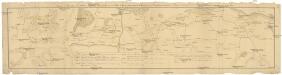
Camps et marches de l'armée imperiale com[m]andée par S.A.S. le prince de Savoye pour retourner de Wesenthal prés de Philippsbourg, et aller passer le Rhein a Mayence, l'armée de France étant campé a Oppenheim prés de céte ville
Mannheim (Německo) Müller, Johann Conrad