Maps of Landkreis Mainz-Bingen
Electorat et Palatinat du Rhein
1 : 190000 Mollova mapová sbírka Fer, Nicolas de Inselin, Charles Danet, Guillaume
Militair Karte von Süd-Deutschland in 20 Sectionen
1 : 400000 5. Section Coulon, Alois von A. von Coulon
Charte des Baierschen [sic] Rheinkreises
1 : 629000 Bavorsko (Německo) Martin Gleditsch
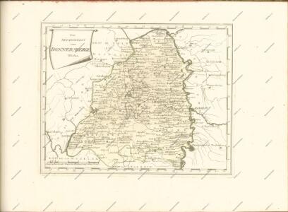
Die Pfalz oder Rhein - Bayern

Palatinatus Inferior, sive electoratus Palatinus ad Rhenum
1 : 366000 Porýní-Falc (Německo) Lotter, Tobias Conrad T. C. Lotter
Palatinatus Inferior, sive electoratus Palatinus ad Rhenum
1 : 366000 Porýní-Falc (Německo) Lotter, Tobias Conrad T. C. Lotter
Palatinatus Inferior, sive electoratus Palatinus ad Rhenum
1 : 370000 Porýní-Falc (Německo) Seutter, Matthäus M. Seutter
Palatinatus Rheni unacum Episctu. Wormatiensi Spirensique Ducatu item Bipontino et adjacentibus
1 : 380000 Mollova mapová sbírka Weigel, Christoph Kauffer, Michael Weigel, Christoph I.
ELECTORATUS et PALATINATUS RHENI EPISCOPATUUM SPIRENSIS et WORMACENSIS DUCATUUM BIPONTII et SIMMERAE et COMITATUUM SPONHEIMENSIS VELDENSIS LEININGENSIS BIRCOFELDENSIS et RHENOGRAVIORUM etc. Nova Tabula
1 : 350000 Porýní (Německo) Wit, Frederik de ex Officina F. de Wit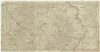
Estats entre la Nied la Sare et le Rhin ou sont la Lorraine allemande le duché de Deux Ponts, les comtés de Bitsche, de Spanheim et de Linange, partie du palatinat meridional l'entrée en Alsace et en Lorraine par les villes de Sarlouis de Hombourg de Landau et leurs environs
1 : 200000 Lotrinsko (Francie) Sengre, Henri Jaillot, Alexis-Hubert Iaillot
Neueste Karte und Richtige Vorstellung Aller Städte, Vestungen, Schlösser und remarquablen Ort, welche die Kron Frankreich zwischen dem Rhein, Saar, Mosel und im Elsaß wirklich besitzet
Mollova mapová sbírka Pfann, Wilhelm Ziegerkunst, Johann
Neueste Karte und Richtige Vorstellung Aller Städte, Vestungen, Schlösser und remarquablen Ort, welche die Kron Frankreich zwischen dem Rhein, Saar, Mosel und im Elsaß wirklich besitzet
Mollova mapová sbírka Pfann, Wilhelm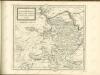

Partie Occidentale Du Palatinat et Eslectorat Du Rhein Le Duché De Simmeren, Les Comtés De Spanheim, et De Veldentz a la Maison Palatine. [...] [Karte], in: Atlas nouveau, contenant toutes les parties du monde [...], Bd. 1, S. 180.
1 Karte aus Atlas Sanson, Nicolas Jaillot, Alexis Hubert und Mortier, Pieter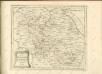

Partie Orientale du Palatinat et Eslectorat du Rhein. Les Eveschés de Spire, de Wormes et le Comté de Linange
1 : 260000 Mollova mapová sbírka Sanson, Guillaume Jaillot, Alexis Hubert
Partie Orientale du Palatinat et Eslectorat du Rhein. Les Eveschés de Spire, de Wormes et le Comté de Linange
1 : 260000 Mollova mapová sbírka Sanson, Guillaume Jaillot, Alexis Hubert
Postirungs-Charte Der am Rhein stehenden Kayserl. und Reichs-Armee Anno 1735
1 : 465000
Le Duché de Luxembourg divisé en Quartier Walon et Allemand
1 : 140000 Mollova mapová sbírka Jaillot, Alexis-Hubert Jaillot, Alexis Hubert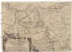
Eigentliche Entwerffung deßn Marquis Spinolae Lägern bey Maintz und Oppenheim
Mohuč (Německo)
Mannheim 113, uit: Special-Karte von Mittel-Europa / nach amtlichen Quellen bearbeitet von W. Liebenow
1 : 300000 titelvariant: W. Liebenow's Mittel-Europa; Annotatie: Titel boven de bladen: W. Liebenow's Mittel-Europa Johannes Wilhelm Liebenow 1822-1897 Frankfurt a. M. : Ludwig Ravenstein
Partie Occidentale du Palatinat et Eslectorat du Rhein
1 : 125000 Mollova mapová sbírka Sanson, Guillaume Jaillot, Alexis Hubert
Mannheim 113, uit: [W. Liebenow's Special-Karte von Mittel-Europa]
1 : 300000 titelvariant: W. Liebenow's Mittel-Europa; Annotatie: Titel boven de bladen: W. Liebenow's Mittel-Europa Johannes Wilhelm Liebenow 1822-1897 Hannover : Hermann Oppermann
Le Cours du Rhein, depuis Spire jusqu'a Mayence
1 : 180000 Mollova mapová sbírka Fer, Nicolas de Fer, Nicolas de
Partie Orientale du Palatinat et Eslectorat du Rhein.
1 : 260000 Mollova mapová sbírka Sanson, Guillaume Jaillot, Alexis Hubert
Partie du Cours du Palatinat du Rhin Levesché de Spire et de Worms les Comté de Spanheim et de Linange levée Sur les lieu
1 : 160000 Mollova mapová sbírka Baillieul, Gaspard Bailleul, Gaspard
Special Carte des Rheinlaufes von Speier bis Bingen nebst den angraentzenden Gegenden von beiden Ufern bis an die Gebirge
1 : 250000 Bingen (Německo) Dewarat, Peter Verhelst, Aegid Schwan und Götz
Section Worms, uit: Charte von dem Grossherzogtum Hessen und dem Herzogtum Nassau / trigonometrisch aufgenommen und hrsg. von C.L.P. Eckhardt
1 : 200000 titelvariant: Karte von Hessen und Nassau Eckhardt, C. L. P Darmstadt : Joh. Wilh. Heyer