Maps of Landkreis Mainz-Bingen

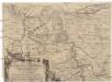
Partie Occidentale Du Palatinat et Eslectorat Du Rhein Le Duché De Simmeren, Les Comtés De Spanheim, et De Veldentz a la Maison Palatine. [...] [Karte], in: Atlas nouveau, contenant toutes les parties du monde [...], Bd. 1, S. 180.
1 Karte aus Atlas Sanson, Nicolas Jaillot, Alexis Hubert und Mortier, Pieter
Electorat et Palatinat du Rhein
1 : 190000 Mollova mapová sbírka Fer, Nicolas de Inselin, Charles Danet, Guillaume

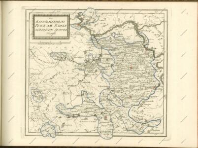
Partie Occidentale du Palatinat et Eslectorat du Rhein
1 : 125000 Mollova mapová sbírka Sanson, Guillaume Jaillot, Alexis Hubert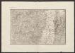
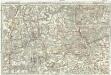
Militair Karte von Süd-Deutschland in 20 Sectionen
1 : 400000 5. Section Coulon, Alois von A. von Coulon
Partie Orientale du Palatinat et Eslectorat du Rhein.
1 : 260000 Mollova mapová sbírka Sanson, Guillaume Jaillot, Alexis Hubert
Die Pfalz oder Rhein - Bayern
Eigentliche Entwerffung deßn Marquis Spinolae Lägern bey Maintz und Oppenheim
Mohuč (Německo)
Carte Particuliere de Pays qui sont situéz entre le Rhein, la Saare, la Moselle, et la Basse Alsace
1 : 150000 Mollova mapová sbírka Jaillot, Alexis-Hubert Jaillot, Alexis Hubert
Partie du Cours du Palatinat du Rhin Levesché de Spire et de Worms les Comté de Spanheim et de Linange levée Sur les lieu
1 : 160000 Mollova mapová sbírka Baillieul, Gaspard Bailleul, Gaspard
Le Cours du Rhein, depuis Spire jusqu'a Mayence
1 : 180000 Mollova mapová sbírka Fer, Nicolas de Fer, Nicolas de
Special Carte des Rheinlaufes von Speier bis Bingen nebst den angraentzenden Gegenden von beiden Ufern bis an die Gebirge
1 : 250000 Bingen (Německo) Dewarat, Peter Verhelst, Aegid Schwan und Götz
Karte eines Theils des ehemaligen Departement des Donnersberges nach Cantons eingetheilt
1 : 178300 Mohuč (Německo : oblast) Veil
150. Mainz, uit: Topographische Uebersichtskarte des Deutschen Reiches / herausgegeben v. d. Kartogr. Abt. d. Königl. Preuß. Landesaufnahme
1 : 200000 titelvariant: Topogr. Übersichtskarte des Deutschen Reiches; Annotatie: Titel boven bladen ook: Topogr. Übersichtskarte des Deutschen Reiches; Annotatie geografische gegevens: Op elk blad twee maatstokken: 10 Kilometer = 5,5 cm; 1 geogr. Meile = 3,6 cm; Legenda onder op elk blad Königlich Preußische Landesaufnahme. Kartographische Abtheilung [S.l : Königlich Preußische Landesaufnahme, Kartographische Abtheilung]
Delineatio Geographica generalis comprehendens VI. Foliis Singulos Principatvs Comitatvs Ditiones Dynastias omnes quotquot Imperio Serenissimi Principis Landgrafii Hasso-Darmstadiensis subsunt :
1 : 180000 Mollova mapová sbírka Bronner, Christian Maximilian Homann, Johann Baptista - dědici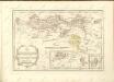

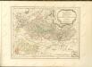
Partie Septentrionalo Des Pays qui sont situéz Entre le Rhein, la Saare, la Moselle, et la Basse Alsace. [Karte], in: Atlas nouveau, contenant toutes les parties du monde [...], Bd. 1, S. 238.
1 Karte aus Atlas Sanson, Nicolas Jaillot, Alexis Hubert und Mortier, Pieter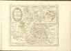
Tractus Hunnorum tabula exactissima, proponens maximam partem Sylvae olim dictae Arduenna, elect. Mogunt. Palat. ad Rhenum, et Trevir. princip. et com. Cattimelib. infer. Nassov. cum adjac. comit. et regionibus intra Rhenum, Mosellam, Saramque, secundum exactissimae vederoviae
Ardeny Buna, Wilhelm C.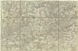
[Poříčí Mosely]
Mosela, řeka-oblast Buna, Wilhelm C.
Section Worms, uit: Charte von dem Grossherzogtum Hessen und dem Herzogtum Nassau / trigonometrisch aufgenommen und hrsg. von C.L.P. Eckhardt
1 : 200000 titelvariant: Karte von Hessen und Nassau Eckhardt, C. L. P Darmstadt : Joh. Wilh. Heyer
Das Rhein-Weinland
1 : 206000 Mohuč-oblast (Německo) Hellrung, Carl Ludwig Baensch, E. Rubach'schen Buchhandlung
Karte über das Überschwemmungsgebiet des Hochwassers im Winter 1882/83 längs des Main- und Rheinstromes in dem Großherzogthum Hessen
1 : 100000 Hessen-Darmstadt, Großherzogliche Landescultur-Inspection Bergsträsser
Mannheim 113, uit: [W. Liebenow's Special-Karte von Mittel-Europa]
1 : 300000 titelvariant: W. Liebenow's Mittel-Europa; Annotatie: Titel boven de bladen: W. Liebenow's Mittel-Europa Johannes Wilhelm Liebenow 1822-1897 Hannover : Hermann Oppermann
Section Mainz, uit: Charte von dem Grossherzogtum Hessen und dem Herzogtum Nassau / trigonometrisch aufgenommen und hrsg. von C.L.P. Eckhardt
1 : 200000 titelvariant: Karte von Hessen und Nassau Eckhardt, C. L. P Darmstadt : Joh. Wilh. Heyer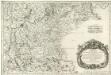
Treveri Archidiacones de Treves, et de Tholey dans le Dioecese de l'Archevesché de Treves.
Mollova mapová sbírka Sanson, Guillaume Sanson, Guillaume
Territorium Seculare Episcopatus Wormatiensis Tabula Geographica
1 : 130000 Mollova mapová sbírka Homann, Johann Baptist Homann, Johann Baptista - dědici