Maps of Region Rhein-Neckar
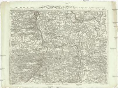
Carte topographique d'Allemagne
1 : 214500 Bádensko (Německo) Facius, Johann Gottlieb chez I.W.A. Iaeger
Carte topographique d'Allemagne
1 : 214500 Bádensko (Německo) Jaeger, Johann Wilhelm Abraham I. et K.
Partie Orientale du Palatinat et Eslectorat du Rhein. Les Eveschés de Spire, de Wormes et le Comté de Linange
1 : 260000 Mollova mapová sbírka Sanson, Guillaume Jaillot, Alexis Hubert
Partie Orientale Du Palatinat et Eslectoriat Du Rhein. Les Eveschés De Spire, De Wormes et Le Comté De Linange. [Karte], in: Atlas nouveau, contenant toutes les parties du monde [...], Bd. 1, S. 184.
1 Karte aus Atlas Sanson, Nicolas Jaillot, Alexis Hubert und Mortier, Pieter
Partie Orientale du Palatinat et Eslectorat du Rhein. Les Eveschés de Spire, de Wormes et le Comté de Linange
1 : 260000 Mollova mapová sbírka Sanson, Guillaume Jaillot, Alexis Hubert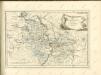

Generalkarte von Zentraleuropa

Per Inclyti Circuli Suevici Supremorum Ordinum :
1 : 160000 Mollova mapová sbírka Pfeffel, Johann Andreas Homann, Johann Baptista - dědici
Per Inclyti Circuli Suevici Supremorum Ordinum :
1 : 160000 Mollova mapová sbírka Pfeffel, Johann Andreas Pfeffel, Johann Andreas I.
Le Theatre de Bellone :
Mollova mapová sbírka Schenk, Pieter Braakman, Adriaan
Circuli Franconicae pars occidentalis, exhibens simul integrum fere electoratum Moguntinum
1 : 860000 Hesensko (Německo) Homann, Johann Baptist Schönborn, Lothar Franz von J. B. Homann
Circuli Franconicae pars occidentalis, exhibens simul integrum fere electoratum Moguntinum
1 : 860000 Hesensko (Německo) Homann, Johann Baptist Lothario, Francisco J. B. Homann
Totius s.r.i. circuli Suevici tabula chorographica, 1
1 Blatt : R. et J. Ottens
Cursus Rheni infra Argentoratum usq; ad Wormatiam, cum adjacentibus Regionibus
1 : 2900000 Mollova mapová sbírka Seutter, Matthäus Seutter, Matthäus
Partie du Palatinat du Rhein, le Duché de Wirtenberg, les Marquisats de Bade et de Durlac, les Eveschés de Worms et de Spire, et le Comté de Linange
1 : 230000 Mollova mapová sbírka Jaillot, Alexis-Hubert Jaillot, Alexis Hubert
Cursus Rheni a Basilea usque ad Bonnam, III. sect. exhibitus
1 : 258000 Alsasko (Francie) Delisle, Guillaume per Homann. Heredes
Cursus Rheni a Basilea usque ad Bonnam, III. sect. exhibitus
1 : 258000 Alsasko (Francie) Delisle, Guillaume per Homann. Heredes
Die Pfalz oder Rhein - Bayern

Carte Tres exacte du Theatre de la Guerre Sur le Rhein
Mollova mapová sbírka Briffaut, Etienne Briffaut, Etienne
Militair Karte von Süd-Deutschland in 20 Sectionen
1 : 400000 5. Section Coulon, Alois von A. von Coulon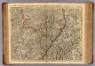
Le Cours du Rhin depuis Strasbourg, jusqu'a Worms et le pays adjacens.
1 : 256000 L'Isle, Guillaume de, 1675-1726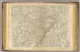
Le Cours du Rhin depuis Strasbourg, jusqu'a Worms et le pays adjacens.
1 : 256000 L'Isle, Guillaume de, 1675-1726

Mannheim 113, uit: Special-Karte von Mittel-Europa / nach amtlichen Quellen bearbeitet von W. Liebenow
1 : 300000 titelvariant: W. Liebenow's Mittel-Europa; Annotatie: Titel boven de bladen: W. Liebenow's Mittel-Europa Johannes Wilhelm Liebenow 1822-1897 Frankfurt a. M. : Ludwig Ravenstein
Mannheim 113, uit: [W. Liebenow's Special-Karte von Mittel-Europa]
1 : 300000 titelvariant: W. Liebenow's Mittel-Europa; Annotatie: Titel boven de bladen: W. Liebenow's Mittel-Europa Johannes Wilhelm Liebenow 1822-1897 Hannover : Hermann Oppermann
Novissima Statuum Imperii Intra Rhenum & Tuberum Repraesentatio
1 : 210000 Mollova mapová sbírka Buna, Wilhelm C. Reinhardt, Andreas Broenner, Heinrich Ludwig
Suevia universa IX. tabulis delineata, 1
1 Blatt : s.n.
Geognostische Reise-Karte der Umgegend von Heidelberg
1 : 250000 Groos
Carte Particuliere Des Pays Qui Sont Situéz Entre Le Rhein, La Saare, la Moselle, Et La Basse Alsace [...] [Karte], in: Atlas nouveau, contenant toutes les parties du monde [...], Bd. 1, S. 244.
1 Karte aus Atlas Sanson, Nicolas Jaillot, Alexis Hubert und Mortier, Pieter