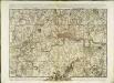
Maps of Enfield
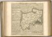
Provincia di Middlesex
1 Karte : Kupferdruck ; 19 x 29 cm Zatta; Zuliani; Pitteri presso Antonio Zatta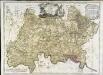
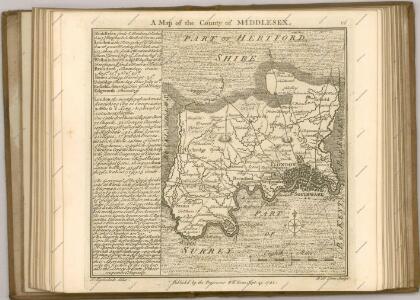
A map of the county of Middlesex
1 Karte : Kupferdruck ; 50 x 68 cm Rocque publish'd according to act of parliament by J. Rocque in the Strand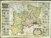
Map of the county of Middlesex
1 Karte : Kupferdruck ; 50 x 50 cm, Bildgrösse 52 x 73 cm Seale s.n.
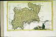
MIDDLE-SEXIA.
[Amsterdam : Joan Blaeu]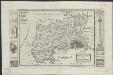
Midlesex
1 : 178000 by H. Moll [London] : [H. Moll etc.]
Middle-Sexia
1 Karte : Kupferdruck ; 37 x 39 cm Blaeu Joan Blaeu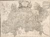
A MAP of the COUNTY of MIDDLESEX Reduced from An Actual Survey in four sheets by John Rocque
The title of this plan appears in decorative cartouche at top centre, with a note on the county's extension and division into parishes at top right. A compass star is included at bottom centre. Scale is given in miles and perches (intervals of around16.5 feet)at bottom left and the border of the map is divided in degrees of longitude from the old meridian of St. Paul's. Symbols are used to indicate land use and reliefs. Rocque, John
Middle-Sexia. [Karte], in: Le théâtre du monde, ou, Nouvel atlas contenant les chartes et descriptions de tous les païs de la terre, Bd. 4, S. 233.
1 Karte aus Atlas Blaeu, Willem Janszoon und Blaeu, Joan Blaeu, Willem Janszoon
Middle-Sexia. [Karte], in: Theatrum orbis terrarum, sive, Atlas novus, Bd. 4, S. 263.
1 Karte aus Atlas Blaeu, Joan Blaeu, Willem Janszoon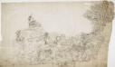
Hampstead
1 : 31680 The individual settlements that make up this area of London are shown by red blocks, with boundary lines indicating the fields separating them. Shading and soft interlining indicate relief, neatly illustrated at Primrose Hill, the summit of which is left bare. The barracks at the edge of Hyde Park are illustrated at the very bottom of the map. The dark blue-black line running from West Drayton to Brentford and Paddington is the Grand Junction Canal. This was London's principal link to the rest of Britain's canals, allowing the passage of goods to and from the industrial towns of the North and Midlands. Hyett includes a ground plan of Kenwood House in Hampstead, showing a level of detail much greater than might be expected from a map with a scale of two inches-to-the-mile. Hyett, William
Middle-Sexia. [Karte], in: Theatrum orbis terrarum, sive, Atlas novus, Bd. 4, S. 263.
1 Karte aus Atlas Blaeu, Joan Blaeu, Willem Janszoon
Accurater Grundriss u: Gegend der kœnigl: gross-brittannischen Haupt und Residentz-Stadt London
1 Karte : Kupferdruck ; 34 x 57 cm, Bildgrösse 50 x 59 cm Homännische Erben
London and Environs, Plate 55, V. III
1 : 100000 Bartholomew, John
Official railway map of London and its environs
1 : 33000 J. & W. Emslie Railway Clearing House
A new correct map of Middlesex
Warburton, John, Bland, Joseph and Smyth, Payler
The M.P. atlas
Edinburgh : W. & A.K. Johnston,
MAP SHEWING THE SEVERAL WALKS OR DELIVERIES IN THE COUNTRY DISTRICTS OF THE TWO PENNY POST, With the Rides to which they are attached numbered to correspond with the figure in the accompanying List
This map was commissioned by the House of Commons for the21st report of the Commissioners of Revenue Inquiry. It title features at top right, with its border divided in degrees of latitude and longitude. Rides and delivery walks in the Two-Penny Country Post are highlighted in colour and numbered for reference. A list of rides and key to delivery walks appears in a table at bottom right. Arrowsmith, Aaron
Fairburn’s Map of the Country twelve miles round London. Second Edition
Fairburn, John London
Die Environs von London
1 : 470000 Londýn (Anglie)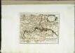
Die Gegend um London
1 Karte : Kupferdruck ; 20 x 26 cm Reilly F. J. J. von Reilly
How to travel in and around London by railway
London : M. Vigers
London and its environs : containing the boundaries of the metropolitan boroughs, the different railroads & stations, the new cemeteries, roads, docks, canals, and all the modern improvements : this map is chiefly from the Ordinance Survey, the railroads and other improvements are from the official copies, the boroughs of Marylebone from the survey published by M.r Britton, the whole corrected from personal observation & measurement
1 : 42000 Davies, Benjamin Rees C. F. Cheffins, lithog ; Wm. S. Orr & Co. ; Letts & Son ; J. Cross & Son ; T.W. Saunders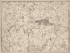
A New and Accurate Survey of the Country about the Cities of LONDON, and WESTMINSTER and the Borough of Southwark for 15 miles in Length & 12 in Depth
In the second half of the18th century, the introduction of turnpike roads and the increased coach-traffic in and out of London contributed to the popularity of the maps of the countryside around the capital. The title of this plan appears in cartouche at bottom centre, with a scale bar near bottom left and its border divided in degrees of latitude and longitude. Bennost
Die Environs von LONDON
Londýn (Anglie)
Die Environs von London
Londýn (Anglie) Landes Industrie Comptoirs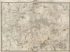
An Exact Survey of the Citys of London, Westminster, ye Borough of Southwark, and the Country near Ten Miles round
This map was first published by Rocque in 1746, and several editions appeared before his death in 1762. His widow Mary Ann carried on the business for a few years, until, in the late 1760s, she transferred the plates of the map to the publishers Carrington Bowles and Robert Sayer, under whose imprints this edition appeared in 1769. Printed in 16 sheets, the map is set within a decorative border. Its title features in English, Latin and French along the top, with emblematic figures below the City arms at top centre, and the compass star at top left. The map is dedicated to Lord Burlington at bottom centre. Scales are given at the foot of the map in versts, leagues, toises, yards and miles. A key to symbols distinguishing orchards, arable land, formal parkland and gardens, pasture, and woodland is included at bottom right. The "New Road" (Marylebone Road), Blackfriars Bridge and the roads across St George's Fields are also shown. Rocque, John
North London (Hills) - OS One-Inch Revised New Series
1 : 63360 Topographic maps Ordnance Survey Ordnance Survey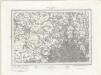
North London (Outline) - OS One-Inch Revised New Series
1 : 63360 Topographic maps Ordnance Survey Ordnance Survey