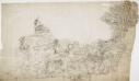
Maps of South Bucks

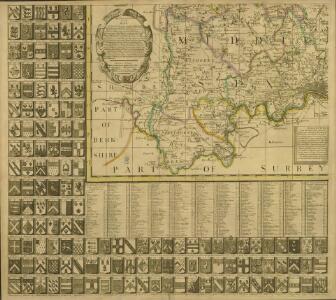
A new correct map of Middlesex
Warburton, John, Bland, Joseph and Smyth, Payler
Midlesex
1 : 178000 by H. Moll [London] : [H. Moll etc.]
Hampstead
1 : 31680 The individual settlements that make up this area of London are shown by red blocks, with boundary lines indicating the fields separating them. Shading and soft interlining indicate relief, neatly illustrated at Primrose Hill, the summit of which is left bare. The barracks at the edge of Hyde Park are illustrated at the very bottom of the map. The dark blue-black line running from West Drayton to Brentford and Paddington is the Grand Junction Canal. This was London's principal link to the rest of Britain's canals, allowing the passage of goods to and from the industrial towns of the North and Midlands. Hyett includes a ground plan of Kenwood House in Hampstead, showing a level of detail much greater than might be expected from a map with a scale of two inches-to-the-mile. Hyett, William
Official railway map of London and its environs
1 : 33000 J. & W. Emslie Railway Clearing House
Uxbridge, Windsor
1 : 31680 This plan of the Chiltern Hills runs from Beaconsfield and Harefield at the top to Windsor Park, Egham and Staines at the bottom. A section of the Grand Junction Canal, running from Harefield down to West Drayton, is shown in aquamarine. The paper carries the watermark "E ,amp; P", standing for Edmeads and Pine. Boyce
The M.P. atlas
Edinburgh : W. & A.K. Johnston,
How to travel in and around London by railway
London : M. Vigers
Carte topographique de le comté de Middlesex, 1
1 Blatt : 53 x 69 cm John Rocque
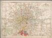
London and its environs : containing the boundaries of the metropolitan boroughs, the different railroads & stations, the new cemeteries, roads, docks, canals, and all the modern improvements : this map is chiefly from the Ordinance Survey, the railroads and other improvements are from the official copies, the boroughs of Marylebone from the survey published by M.r Britton, the whole corrected from personal observation & measurement
1 : 42000 Davies, Benjamin Rees C. F. Cheffins, lithog ; Wm. S. Orr & Co. ; Letts & Son ; J. Cross & Son ; T.W. Saunders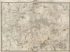
An Exact Survey of the Citys of London, Westminster, ye Borough of Southwark, and the Country near Ten Miles round
This map was first published by Rocque in 1746, and several editions appeared before his death in 1762. His widow Mary Ann carried on the business for a few years, until, in the late 1760s, she transferred the plates of the map to the publishers Carrington Bowles and Robert Sayer, under whose imprints this edition appeared in 1769. Printed in 16 sheets, the map is set within a decorative border. Its title features in English, Latin and French along the top, with emblematic figures below the City arms at top centre, and the compass star at top left. The map is dedicated to Lord Burlington at bottom centre. Scales are given at the foot of the map in versts, leagues, toises, yards and miles. A key to symbols distinguishing orchards, arable land, formal parkland and gardens, pasture, and woodland is included at bottom right. The "New Road" (Marylebone Road), Blackfriars Bridge and the roads across St George's Fields are also shown. Rocque, John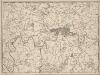
A New and Accurate Survey of the Country about the Cities of LONDON, and WESTMINSTER and the Borough of Southwark for 15 miles in Length & 12 in Depth
In the second half of the18th century, the introduction of turnpike roads and the increased coach-traffic in and out of London contributed to the popularity of the maps of the countryside around the capital. The title of this plan appears in cartouche at bottom centre, with a scale bar near bottom left and its border divided in degrees of latitude and longitude. Bennost
A PLAN of LONDON on the Same Scale as that of PARIS: In Order to ascertain the Difference of the extent of these two Rivals
The title of this plan appears in English and French along the top of the plate, along with the scale bars. The publisher’s imprint and dedication to John, Duke of Montague, feature below the plan. Allegorical figures are depicted at bottom centre holding the Duke's coat of arms. The border of the map is divided in degrees of longitude from the old meridian at St Paul's. Rocque, John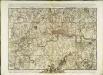
A plan of London
1 Karte : Kupferdruck ; 44 x 62 cm Rocque; Parr John Rocque
London, England.
1 : 1500000 Colton, G.W.
Die Environs von LONDON
Londýn (Anglie)
Die Environs von London
Londýn (Anglie) Landes Industrie Comptoirs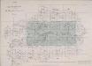
INDEX TO THE PLAN OF LONDON MADE FOR The Metropolitan Commissioners of Sewers
This map's title and imprint feature at top left, with an explanatory note at bottom right and scale bar at bottom centre. The map is divided into rectangles, forming the index to two "London and its Environs" Ordnance Survey maps. The cholera outbreaks of the 1830s and 40s forced the government to improve London drainage and sewage disposal. The Commission of Sewers was established to combine seven of the eight existing sewage companies into one, unifying their drainage systems. Metropolitan Commission of Sewers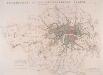
JURISDICTION OF THE METROPOLITAN POLICE
This map illustrates plans for the reform of the jurisdiction of Metropolitan Police. Based on Dawson's map of 1832, the map’s title appear along the top, with compass star at top right, explanatory note at bottom left, and a scale bar at bottom right. District boundaries are highlighted in colour, with the old limits of London, Westminster and Southwark shaded. Formed in 1829, the Metropolitan Police had its jurisdiction extended in 1839to Greater London - an area taken to mean all parishes partly within twelve miles of Charing Cross or wholly within fifteen miles of Charing Cross. In the same year, the City of London formed its own police force. Dawson, Lieut. Robert K.
Environs of London.
1 : 95000 Colton, G.W.
Environs of London.
Colton, G.W.
LONDON AND ITS ENVIRONS 248
This is a later edition of the map of London and the suburbs first issued by Davies in 1840. The map features title in top border, scale bar at bottom centre and key to symbols below the map. A note below the map states that the map contains "the boundaries of the Metropolitan Boroughs, the different railroads and stations, the new cemeteries and roads, docks, canals and all the modern improvements. The map is chiefly drawn from the Ordnance Survey, the railroads and the other improvements from the official copies and the Borough of Marylebone from the survey published by Mr Britton. The whole corrected from personal observations and measurements. “Borough and county boundaries are highlighted in colour, with principal roads represented in yellow. Davies, Benjamin, Rees
LONDON AND ITS ENVIRONS 241
This is a later edition of the map of London and the suburbs first issued by Davies in 1840. The map features title in top border, scale bar at bottom centre and key to symbols below the map. A note below the map states that the map contains "the boundaries of the Metropolitan Boroughs, the different railroads and stations, the new cemeteries and roads, docks, canals and all the modern improvements. The map is chiefly drawn from the Ordnance Survey, the railroads and the other improvements from the official copies and the Borough of Marylebone from the survey published by Mr Britton. The whole corrected from personal observations and measurements." Davies, Benjamin Rees
London.
1 : 95000 Colton, G.W.
Plan of a Proposed TURNPIKE ROAD From St. JOHN'S CHAPEL, ST. MARYLEBONE into the Great North Road Near the 8 Mile Stone at Finchley
1 : 31680 Plan of the proposed turnpike road from Regent's Park to Finchley, today's Finchley Road. The plan features title at top right, scale bars at lower right and sections of the road in elevation at the foot of the plate, with the new road represented by a double dotted line coloured red. Down the left of the plate a table gives distances between stations along the road and shows the savings in milage generated by the new road. Phillips, Henry
[Recto], uit: Route map and guide : [London]
1 : 50000 London : London General Omnibus Co.
North London (Hills) - OS One-Inch Revised New Series
1 : 63360 Topographic maps Ordnance Survey Ordnance Survey
North London (Outline) - OS One-Inch Revised New Series
1 : 63360 Topographic maps Ordnance Survey Ordnance Survey
Stanford's new two inch map of London and its environs
1 : 31680 Londýn (Anglie) Edward Stanford