Maps of Enfield
Hampstead
1 : 31680 The individual settlements that make up this area of London are shown by red blocks, with boundary lines indicating the fields separating them. Shading and soft interlining indicate relief, neatly illustrated at Primrose Hill, the summit of which is left bare. The barracks at the edge of Hyde Park are illustrated at the very bottom of the map. The dark blue-black line running from West Drayton to Brentford and Paddington is the Grand Junction Canal. This was London's principal link to the rest of Britain's canals, allowing the passage of goods to and from the industrial towns of the North and Midlands. Hyett includes a ground plan of Kenwood House in Hampstead, showing a level of detail much greater than might be expected from a map with a scale of two inches-to-the-mile. Hyett, William

MIDDLE-SEXIA.
[Amsterdam : Joan Blaeu]
Middle-Sexia
1 Karte : Kupferdruck ; 37 x 39 cm Blaeu Joan Blaeu
Provincia di Middlesex
1 Karte : Kupferdruck ; 19 x 29 cm Zatta; Zuliani; Pitteri presso Antonio Zatta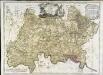
A map of the county of Middlesex
1 Karte : Kupferdruck ; 50 x 68 cm Rocque publish'd according to act of parliament by J. Rocque in the Strand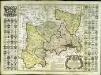
Map of the county of Middlesex
1 Karte : Kupferdruck ; 50 x 50 cm, Bildgrösse 52 x 73 cm Seale s.n.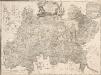
A MAP of the COUNTY of MIDDLESEX Reduced from An Actual Survey in four sheets by John Rocque
The title of this plan appears in decorative cartouche at top centre, with a note on the county's extension and division into parishes at top right. A compass star is included at bottom centre. Scale is given in miles and perches (intervals of around16.5 feet)at bottom left and the border of the map is divided in degrees of longitude from the old meridian of St. Paul's. Symbols are used to indicate land use and reliefs. Rocque, John
Middle-Sexia. [Karte], in: Le théâtre du monde, ou, Nouvel atlas contenant les chartes et descriptions de tous les païs de la terre, Bd. 4, S. 233.
1 Karte aus Atlas Blaeu, Willem Janszoon und Blaeu, Joan Blaeu, Willem Janszoon
Middle-Sexia. [Karte], in: Theatrum orbis terrarum, sive, Atlas novus, Bd. 4, S. 263.
1 Karte aus Atlas Blaeu, Joan Blaeu, Willem Janszoon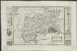
Midlesex
1 : 178000 by H. Moll [London] : [H. Moll etc.]
Accurater Grundriss u: Gegend der kœnigl: gross-brittannischen Haupt und Residentz-Stadt London
1 Karte : Kupferdruck ; 34 x 57 cm, Bildgrösse 50 x 59 cm Homännische Erben
A new correct map of Middlesex
Warburton, John, Bland, Joseph and Smyth, Payler
Official railway map of London and its environs
1 : 33000 J. & W. Emslie Railway Clearing House
North London (Hills) - OS One-Inch Revised New Series
1 : 63360 Topographic maps Ordnance Survey Ordnance Survey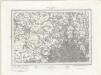
North London (Outline) - OS One-Inch Revised New Series
1 : 63360 Topographic maps Ordnance Survey Ordnance Survey
The M.P. atlas
Edinburgh : W. & A.K. Johnston,
Chipping Barnet
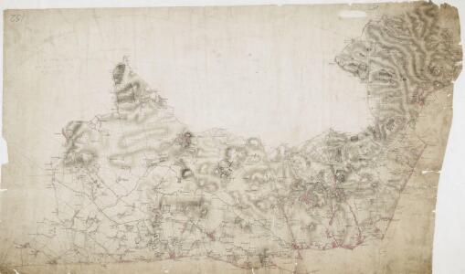
1 : 31680 The most obvious features of this plan are major roads coloured yellow, with their cumulative lengths noted at intervals of one mile. North is not orientated towards the top. As a result,Watford appears to the left of St Albans, and the boundary between Middlesex and Hertfordshire (a dashed black-ink line)runs from the top left of the map down through Elstree to Hadley. The paper carries a watermark from the James Whatman Turkey Mill. Hyett, William
Plan of a Proposed TURNPIKE ROAD From St. JOHN'S CHAPEL, ST. MARYLEBONE into the Great North Road Near the 8 Mile Stone at Finchley
1 : 31680 Plan of the proposed turnpike road from Regent's Park to Finchley, today's Finchley Road. The plan features title at top right, scale bars at lower right and sections of the road in elevation at the foot of the plate, with the new road represented by a double dotted line coloured red. Down the left of the plate a table gives distances between stations along the road and shows the savings in milage generated by the new road. Phillips, Henry
Carte topographique de le comté de Middlesex, 1
1 Blatt : 53 x 69 cm John Rocque
Carte topographique de le comté de Middlesex, 2
1 Blatt : 53 x 73 cm John Rocque
JURISDICTION OF THE METROPOLITAN POLICE
This map illustrates plans for the reform of the jurisdiction of Metropolitan Police. Based on Dawson's map of 1832, the map’s title appear along the top, with compass star at top right, explanatory note at bottom left, and a scale bar at bottom right. District boundaries are highlighted in colour, with the old limits of London, Westminster and Southwark shaded. Formed in 1829, the Metropolitan Police had its jurisdiction extended in 1839to Greater London - an area taken to mean all parishes partly within twelve miles of Charing Cross or wholly within fifteen miles of Charing Cross. In the same year, the City of London formed its own police force. Dawson, Lieut. Robert K.
London and its environs : containing the boundaries of the metropolitan boroughs, the different railroads & stations, the new cemeteries, roads, docks, canals, and all the modern improvements : this map is chiefly from the Ordinance Survey, the railroads and other improvements are from the official copies, the boroughs of Marylebone from the survey published by M.r Britton, the whole corrected from personal observation & measurement
1 : 42000 Davies, Benjamin Rees C. F. Cheffins, lithog ; Wm. S. Orr & Co. ; Letts & Son ; J. Cross & Son ; T.W. Saunders
How to travel in and around London by railway
London : M. Vigers
Geological map London.
1 : 90000 Letts, Son & Co.
Orographical map London.
1 : 90000 Letts, Son & Co.
London, England.
1 : 1500000 Colton, G.W.
LONDON AND ITS ENVIRONS 248
This is a later edition of the map of London and the suburbs first issued by Davies in 1840. The map features title in top border, scale bar at bottom centre and key to symbols below the map. A note below the map states that the map contains "the boundaries of the Metropolitan Boroughs, the different railroads and stations, the new cemeteries and roads, docks, canals and all the modern improvements. The map is chiefly drawn from the Ordnance Survey, the railroads and the other improvements from the official copies and the Borough of Marylebone from the survey published by Mr Britton. The whole corrected from personal observations and measurements. “Borough and county boundaries are highlighted in colour, with principal roads represented in yellow. Davies, Benjamin, Rees
Environs of London.
Colton, G.W.