Maps of London

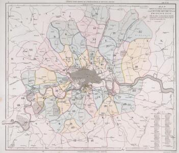
MAP SHEWING THE SEVERAL WALKS OR DELIVERIES IN THE COUNTRY DISTRICTS OF THE TWO PENNY POST, With the Rides to which they are attached numbered to correspond with the figure in the accompanying List
This map was commissioned by the House of Commons for the21st report of the Commissioners of Revenue Inquiry. It title features at top right, with its border divided in degrees of latitude and longitude. Rides and delivery walks in the Two-Penny Country Post are highlighted in colour and numbered for reference. A list of rides and key to delivery walks appears in a table at bottom right. Arrowsmith, Aaron

Fairburn’s Map of the Country twelve miles round London. Second Edition
Fairburn, John London
England & Wales. Diagram of London
Ordnance Survey
London and Environs, Plate 55, V. III
1 : 100000 Bartholomew, John
Official railway map of London and its environs
1 : 33000 J. & W. Emslie Railway Clearing House
MAP of the COUNTRY 15 MILES ROUND London SHEWING BY A YELLOW CIRCLE OF 3 MILEs, THE LIMITS OF THE TWOPENNY POST DELIVERY
This map was commissioned by the House of Commons for the ninth report of the Post Office Management. The map's title features at top right, with an explanatory note and scale bar at bottom right. It shows the boundaries of the London Two-Penny Post, and the old and current boundaries of the Country Three-Penny Post, with mail routes highlighted in red. Post stages on the edges of the post area allowed mail to be exchanged between the London and the General Post on all main roads out of London. Wyld, James
Delineatio ac finitima regio Magnae Brittaniae metropoleos Londini
Londýn (Anglie) Seutter, Matthäus a Matt. Seutter
Die Gegend um London
1 Karte : Kupferdruck ; 20 x 26 cm Reilly F. J. J. von Reilly
The Environs Of London.
1 : 95000 Colton, G.W.
London environs.
1 : 91500 Society for the Diffusion of Useful Knowledge (Great Britain)
Die Environs von London
1 : 470000 Londýn (Anglie)
The M.P. atlas
Edinburgh : W. & A.K. Johnston,
Accurater Grundriss u: Gegend der kœnigl: gross-brittannischen Haupt und Residentz-Stadt London
1 Karte : Kupferdruck ; 34 x 57 cm, Bildgrösse 50 x 59 cm Homännische Erben
Geological map London.
1 : 90000 Letts, Son & Co.
Orographical map London.
1 : 90000 Letts, Son & Co.
How to travel in and around London by railway
London : M. Vigers
Environs of London.
1 : 95000 Colton, G.W.
Provincia di Middlesex
1 Karte : Kupferdruck ; 19 x 29 cm Zatta; Zuliani; Pitteri presso Antonio Zatta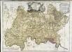
A map of the county of Middlesex
1 Karte : Kupferdruck ; 50 x 68 cm Rocque publish'd according to act of parliament by J. Rocque in the Strand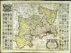
Map of the county of Middlesex
1 Karte : Kupferdruck ; 50 x 50 cm, Bildgrösse 52 x 73 cm Seale s.n.
Die Environs von LONDON
Londýn (Anglie)
Die Environs von London
Londýn (Anglie) Landes Industrie Comptoirs
MIDDLE-SEXIA.
[Amsterdam : Joan Blaeu]
London, England.
1 : 1500000 Colton, G.W.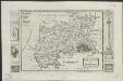
Midlesex
1 : 178000 by H. Moll [London] : [H. Moll etc.]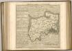

London and its environs : containing the boundaries of the metropolitan boroughs, the different railroads & stations, the new cemeteries, roads, docks, canals, and all the modern improvements : this map is chiefly from the Ordinance Survey, the railroads and other improvements are from the official copies, the boroughs of Marylebone from the survey published by M.r Britton, the whole corrected from personal observation & measurement
1 : 42000 Davies, Benjamin Rees C. F. Cheffins, lithog ; Wm. S. Orr & Co. ; Letts & Son ; J. Cross & Son ; T.W. Saunders
Environs of London.
Colton, G.W.